
Ploërdut
Ploërdut
Pleurdud | |
|---|---|
 The Church of Saint-Pierre, in Ploërdut | |
.svg) Coat of arms | |
Location of Ploërdut  | |
 Ploërdut  Ploërdut | |
| Coordinates: 48°05′19″N 3°17′14″W / 48.0886°N 3.2872°W | |
| Country | France |
| Region | Brittany |
| Department | Morbihan |
| Arrondissement | Pontivy |
| Canton | Gourin |
| Intercommunality | Roi Morvan Communauté |
| Government | |
| • Mayor (2020–2026) | Jean-Luc Guilloux[1] |
| Area 1 | 75.83 km2 (29.28 sq mi) |
| Population (2021)[2] | 1,243 |
| • Density | 16/km2 (42/sq mi) |
| Time zone | UTC+01:00 (CET) |
| • Summer (DST) | UTC+02:00 (CEST) |
| INSEE/Postal code | 56163 /56160 |
| Elevation | 114–285 m (374–935 ft) |
| 1 French Land Register data, which excludes lakes, ponds, glaciers > 1 km2 (0.386 sq mi or 247 acres) and river estuaries. | |
Ploërdut (French pronunciation: [ploɛʁdyt];[3] Breton: Pleurdud) is a commune in the Morbihan department in Brittany in north-western France.[4]
Population[edit]
|
| |||||||||||||||||||||||||||||||||||||||||||||||||||||||||||||||||||||||||||||||||||||||||||||||||||||||||||||||
| ||||||||||||||||||||||||||||||||||||||||||||||||||||||||||||||||||||||||||||||||||||||||||||||||||||||||||||||||
| Source: EHESS[5] and INSEE (1968-2020)[6] | ||||||||||||||||||||||||||||||||||||||||||||||||||||||||||||||||||||||||||||||||||||||||||||||||||||||||||||||||
Geography[edit]
Ploërdut is located in Northwestern part of Morbihan, 16 km (9.9 mi) east of Le Faouët, 22 km (14 mi) west of Pontivy and 38 km (24 mi) north of Lorient. Historically, the village belongs to Vannetais.
History[edit]
The romanesque nave church dates from the eleventh or twelve century.
Gallery[edit]
-
 The town hall
 -
 Chapel Notre Dame de Crénénan
 -
 Chapel of Lochrist
 -
 Chapel Notre Dame de la Fosse
 -
 Iron Age stele christianized of Saint Ildut
 -
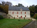 Manor of Kerservant

_Chapelle_Notre-Dame-de-Cr%C3%A9n%C3%A9nan_01.JPG)


See also[edit]
- Kério, a hamlet of Ploërdut
- Communes of the Morbihan department
References[edit]
- ^ "Maires du Morbihan" (PDF). Préfecture du Morbihan. 7 July 2020.
- ^ "Populations légales 2021". The National Institute of Statistics and Economic Studies. 28 December 2023.
- ^ France 3 Bretagne. "Succès de la maison médicale de Ploerdut (56)". YouTube. Archived from the original on 12 December 2021.
{{cite web}}: CS1 maint: numeric names: authors list (link) - ^ Commune de Ploërdut (56163), INSEE
- ^ Des villages de Cassini aux communes d'aujourd'hui: Commune data sheet Ploërdut, EHESS (in French).
- ^ Population en historique depuis 1968, INSEE
External links[edit]
Wikimedia Commons has media related to Ploërdut.
- Base Mérimée: Search for heritage in the commune, Ministère français de la Culture. (in French)
- Mayors of Morbihan Association (in French)
| Authority control databases: National |
|---|
This Morbihan geographical article is a stub. You can help Wikipedia by expanding it. |