
Periyababusamudram
Periyababusamudram
Periyababusamuthiram | |
|---|---|
 Ardhanarishvara Statue & Omkareshwar temple | |
| Nickname: PBS | |
 Periyababusamudram Villupuram, Tamil Nadu | |
| Coordinates: 11°56′30″N 79°41′01″E / 11.9415340°N 79.6835375°E | |
| Country | |
| State | Tamil Nadu |
| Region | Tondai Nadu |
| District | Viluppuram |
| Government | |
| • Type | Gram Panchayat |
| Languages | |
| • Official | Tamil |
| Time zone | UTC+5:30 (IST) |
| PIN | 605102[1] |
| Telephone code | +91–0413(STD Code) |
| Vehicle registration | TN–32 |
| Climate | Aw(Köppen) |
| Distance from Chennai | 165 kilometres (103 mi) |
| Distance from Viluppuram | 24 kilometres (15 mi) |
| Distance from Puducherry | 15 kilometres (9.3 mi) |
| Distance from Cuddalore | 29 kilometres (18 mi) |
Periyababusamudram or Periyababusamuthiram is a village located in Kandamangalam block in Villupuram district of Tamil Nadu.[2] This village falls under Vanur Assembly constituency and Viluppuram Lok Sabha constituency.
Population[edit]
Vanniya Kula kshatriya's (Vanniya Gounder) community is the majority (55%) and Adi Dravida (25%) and other Vannar, Kuyavar, Naidu community (20%) live in this village.[3]
Economy[edit]

Most of the people in this village are in agriculture and brick kiln work. Paddy, Sugarcane, ulundham, groundnut, Cassava etc. are cultivated here as major crops. And some work in nearby factories. The pambai river, lake and ponds here add much beauty to the village and are an important source of agriculture.
Climate[edit]
The climate of Periyababusamudram is classified by the Köppen climate classification as tropical wet and dry,[4] similar to that of coastal Pondicherry. Summer lasts from April to early June, when maximum temperatures may reach 41 °C (106 °F). The average maximum temperature is 36 °C (97 °F). Minimum temperatures are in the order of 28–32 °C (82–90 °F). This is followed by a period of high humidity and occasional thundershowers from June until September.
The northeast monsoon sets in during the middle of October, and periyababusamudram gets the bulk of its annual rainfall during the period from October to December. The annual average rainfall is 1,355 millimetres or 53 inches.[5] Winters are very warm, with highs of 30 °C (86 °F) and lows often dipping to around 18–20 °C (64–68 °F).
| Climate data for Periyababusamudram | |||||||||||||
|---|---|---|---|---|---|---|---|---|---|---|---|---|---|
| Month | Jan | Feb | Mar | Apr | May | Jun | Jul | Aug | Sep | Oct | Nov | Dec | Year |
| Record high °C (°F) | 33.2 (91.8) |
35.2 (95.4) |
37.2 (99.0) |
41.8 (107.2) |
43.1 (109.6) |
41.7 (107.1) |
40.7 (105.3) |
40.2 (104.4) |
38.6 (101.5) |
37.9 (100.2) |
36.3 (97.3) |
32.5 (90.5) |
43.1 (109.6) |
| Mean daily maximum °C (°F) | 29.0 (84.2) |
30.0 (86.0) |
31.2 (88.2) |
32.8 (91.0) |
34.6 (94.3) |
35.8 (96.4) |
34.5 (94.1) |
33.9 (93.0) |
33.1 (91.6) |
31.5 (88.7) |
29.8 (85.6) |
29.0 (84.2) |
32.1 (89.8) |
| Mean daily minimum °C (°F) | 21.9 (71.4) |
22.5 (72.5) |
23.8 (74.8) |
25.9 (78.6) |
26.8 (80.2) |
26.5 (79.7) |
25.7 (78.3) |
25.2 (77.4) |
24.9 (76.8) |
24.5 (76.1) |
23.6 (74.5) |
22.6 (72.7) |
24.5 (76.1) |
| Record low °C (°F) | 17.1 (62.8) |
17.3 (63.1) |
18.8 (65.8) |
21.9 (71.4) |
21.9 (71.4) |
21.5 (70.7) |
21.6 (70.9) |
21.4 (70.5) |
21.5 (70.7) |
19.6 (67.3) |
16.5 (61.7) |
17.1 (62.8) |
16.5 (61.7) |
| Average rainfall mm (inches) | 12.3 (0.48) |
22.2 (0.87) |
19.3 (0.76) |
7.8 (0.31) |
48.6 (1.91) |
48.0 (1.89) |
89.5 (3.52) |
132.3 (5.21) |
132.8 (5.23) |
273.9 (10.78) |
350.0 (13.78) |
217.3 (8.56) |
1,354 (53.3) |
| Average rainy days | 0.9 | 0.9 | 0.8 | 0.4 | 1.9 | 2.8 | 5.3 | 6.7 | 6.5 | 10.3 | 11.8 | 6.8 | 55.0 |
| Source: India Meteorological Department (record high and low up to 2010)[6] | |||||||||||||
Temples[edit]


- Puliyampattu mariyamman temple
- Periyandavar temple
- Omkareshwar (Lord sivan) temple
- Draupathi Amman temple
- Pillaiyar temple
- Perumal temple
- Ayyanar temple
- Theepanjamman temple
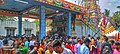
In this village there is a Chariot (ther) about 80 feet high and the Chariot Festival is held once a year.
The Streets[edit]
- Pillaiyar Koil Street
- Aalansalai
- Theradi Street
- Anna Nagar
- Ayyanar Koil Street
- Vanur Road
- Bharathi Street
- Kurukku street
- Lake Street
- Periyababusamudram Colony
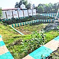
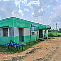
Facilities[edit]

- Govt high school
- Anganwadi centre
- Govt sub health centre
- Vao office
- Panchayat office
- Ration shop
- Library
- Post office
Major political parties[edit]
Major political parties in this village;
Transport[edit]
Road[edit]

This village is located about 3 km from Kandamangalam on the Vanur road.
From this village, Puducherry is 18 km in the east direction, Villupuram is 23 km in the west direction and Cuddalore is 21 km in the south east direction. At a distance of 3 km from here, the town of Kandamangalam is on the Villupuram - Nagapattinam national Highway, from where there are frequent buses to Puducherry and Villupuram. A bus plies to Puducherry and Villupuram from Kalithrampet, a village 2 km from Periyababusamudram village.
A national highway project from Villupuram to Chennai via ECR has been announced by the central government, the highway passes through this village and work is currently underway.
Rail[edit]

Chinnababusamudram railway station is 3 km from here. Trains run from this station to Puducherry, Villupuram, Chennai, Tirupati, etc. It has daily trains connecting the city with Chennai apart from non-daily trains towards prime cities including Mangaluru, Tiruchirapalli, Bengaluru, Kolkata, New Delhi, Bhubaneshwar and Mumbai via Villupuram.
Air[edit]
The nearest airport is Pondicherry Airport[7] at Pondicherry,[8] in Puducherry, approximately 15 km from Periyababusamudram. Pondicherry Airport is connected to Bangalore by commercial airlines.
The nearest major airport is the Chennai International Airport (MAA), approximately 143 km from the town; the next closest major airport is Tiruchirapalli international Airport, approximately 192 km from the village.
Gallery[edit]
-
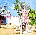 Ardhanarishvara statue
 -
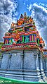 Draupathi amman koil Vimana
 -
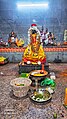 Draupathi amman
 -
 Draupathi Amman temple
 -
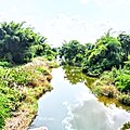 Pambai river
 -
 Draupathi amman koil
 -
 Pillaiyar koil
 -
 Govt sub health centre
 -
 Library
 -
 Periyandavar koil
 -
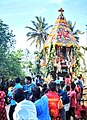 Chariot
 -
 Omkareshwar koil
 -
 Ayyanar koil
 -
 Panchayat office
 -
 Village Administrative office
 -
 Post office
 -
 Periyababusamudram at morning sunrise


References[edit]
- ^ "Pin Code: PERIYABABUSAMUDRAM, VILLUPURAM, TAMIL NADU, India, Pincode.net.in". pincode.net.in. Retrieved 21 January 2024.
- ^ "Gram Panchayat (ग्राम पंचायत): PERIYABABUSAMUDRAM (பெரியபாபுசமுத்திரம் )". localbodydata.com. Retrieved 21 January 2024.
- ^ "Periyababusamudram Population - Viluppuram, Tamil Nadu".
- ^ "Climate: periyababusamudram– Climate graph, Temperature graph, Climate table". Climate-Data.org. Retrieved 6 October 2013.
- ^ "Government of India". Archived from the original on 26 July 2009. Retrieved 10 July 2009.
- ^ "Ever recorded Maximum and minimum temperatures up to 2010" (PDF). India Meteorological Department. Archived from the original (PDF) on 16 March 2014. Retrieved 11 April 2015.
- ^ "Puducherry airport to go on stream in October". The Economic Times. 3 Sep 2011. Retrieved 3 January 2012.
- ^ "Flight operations await new terminal". IBN Live. 10 May 2012. Archived from the original on 13 May 2012. Retrieved 3 July 2012.