Paegam County
Paegam County
백암군 | |
|---|---|
| Korean transcription(s) | |
| • Chosŏn'gŭl | 백암군 |
| • Hancha | 白岩郡 |
| • McCune-Reischauer | Paegam-gun |
| • Revised Romanization | Baegam-gun |
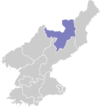
 Map of Ryanggang showing the location of Paegam | |
| Country | North Korea |
| Province | Ryanggang |
| Administrative divisions | 1 ŭp, 19 workers' districts, 4 ri |
| Area | |
| • Total | 2,313 km2 (893 sq mi) |
| Population (2008[1]) | |
| • Total | 67,683 |
| • Density | 29/km2 (76/sq mi) |
Paegam County is a kun, or county, in Ryanggang province, North Korea.
Geography[edit]
The terrain is mountainous, as Paegam lies atop the Paektu Plateau, the site of North Korea's tallest mountains. The Hamgyŏng and Machŏllyŏng ranges pass through the county; the highest point is Kwesangbong. There are many streams; the chief of these is the Sodusu (서두수). There are also wetlands; some 91% of the county's area is forestland.
Administrative divisions[edit]
Paegam county is divided into 1 ŭp (town), 19 rodongjagu (workers' districts) and 4 ri (villages):
|
Climate[edit]
Due to its inland location, the county has a severely cold continental climate. Paegam also has the highest wind speeds of any district in North Korea.
Economy[edit]
Mining and logging are important local industries. Mineral resources in the county include magnesite, alunite, kaolinite, copper, dolomite, tungsten, lead, zinc, gold and peat. Agriculture also plays a role, although only 4% of the county's land is cultivated. Local crops include wheat, barley, potatoes and soybeans. Livestock are also raised.
Transportation[edit]
Paegam is connected to the national road and rail grids; the Paektusan Ch'ŏngnyŏn and Paengmu lines of the Korean State Railway pass through the county.
See also[edit]
External links[edit]
- In Korean language online encyclopedias:
References[edit]

