
Oud-Aa
Oud-Aa | |
|---|---|
Hamlet | |
 Farm in Oud-AA | |
 Oud-Aa Location in the Netherlands  Oud-Aa Oud-Aa (Netherlands) | |
| Coordinates: 52°10′48″N 4°58′19″E / 52.18000°N 4.97194°E | |
| Country | Netherlands |
| Province | Utrecht |
| Municipality | Stichtse Vecht |
| Area | |
| • Total | 3.24 km2 (1.25 sq mi) |
| Population (2021)[1] | |
| • Total | 135 |
| • Density | 42/km2 (110/sq mi) |
| Time zone | UTC+1 (CET) |
| • Summer (DST) | UTC+2 (CEST) |
| Postal code | 3621[1] |
| Dialing code | 0346 |
Oud-Aa is a hamlet in the Dutch province of Utrecht (province). It is a part of the municipality of Stichtse Vecht, and lies about 13 km northeast of Woerden.
The hamlet was first mentioned in 1138 as "juxta lacum qui vocatur A" (translation: Next to the lake called A), and refers to the Aa River which is a tributary of the Angstel River. Oud (old) has been added to distinguish from Nieuwer-Ter-Aa.[2] The postal authorities have placed it under Breukelen,[3] and there are no place name signs. The castle Ruwiel was located in Oud-Aa, however it was destroyed in 1673 by the French, and now contains a farm. In 1840, it was home to 315 people.[4] There also was a local former municipality called Ruwiel.
-
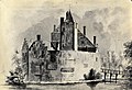 Former Ruwiel Castle seen from the east, 1646-1647
 -
 1865 map of Oud Aa with castle remains
 -
 Sketch map of the former Ruwiel Castle islet, 2022
 -
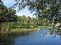 Former Ruwiel Castle islet seen from the southwest, 2022
 -
 Former Ruwiel Castle islet seen from the southeast, 2022

_-_Breukelerwaardsche_Polder_met_kasteelrestant_Ruwiel_en_Klein_Ruwiel.jpg)


References[edit]
- ^ a b c "Kerncijfers wijken en buurten 2021". Central Bureau of Statistics. Retrieved 27 March 2022.
- ^ "Oud-Aa - (geografische naam)". Etymologiebank (in Dutch). Retrieved 27 March 2022.
- ^ "Postcode 3621 in Breukelen". Postcode bij adres (in Dutch). Retrieved 27 March 2022.
- ^ "Oud-Aa". Plaatsengids (in Dutch). Retrieved 27 March 2022.
This Utrecht location article is a stub. You can help Wikipedia by expanding it. |