
Opalchenie Peak
| Opalchenie Peak | |
|---|---|
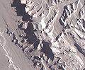
 Craddock Massif and Vinson Plateau in the left background, east view from above Rutford Ice Stream, West Antarctica | |
| Highest point | |
| Elevation | 4,503.5 m (14,775 ft)[1] |
| Prominence | 63 m (207 ft)[1] |
| Isolation | 0.8 km (0.50 mi)[1] |
| Coordinates | 78°34′02″S 85°34′53″W / 78.56722°S 85.58139°W |
| Geography | |
 Opalchenie Peak | |
| Location | Ellsworth Mountains |
| Parent range | Sentinel Range |
| Climbing | |
| First ascent | Unclimbed |
| Easiest route | Rock/ice climb |
Opalchenie Peak (Bulgarian: връх Опълчение, romanized: vrah Opalchenie, IPA: [ˈvrɤx opɐɫˈt͡ʃɛniɛ]) is the peak rising to 4,503.5 metres (14,775 ft)[1] at the south extremity of the ice-covered Vinson Plateau, Sentinel Range in the Ellsworth Mountains, Antarctica. It is of low topographic prominence, just 63 metres (207 ft),[1] with parent summit Fukushima Peak (4,634 metres (15,203 ft)). The feature has a partly ice-free summit and south slopes, where two parallel ridges descend steeply southwestwards with Donnellan Glacier flowing in between and Mount Slaughter rising on the more southerly ridge.[2] The northerly ridge was climbed up to the summit plateau by American Robert Anderson in November 1992, and subsequently used to establish a new route to Mount Vinson in 2003.[3][4] Opalchenie Peak overlooks Vinson Plateau on the north, Craddock Massif on the southeast and upper Nimitz Glacier area on the southwest.
The peak is named after the Bulgarian Volunteer Force in the 1877-1878 Russo-Turkish War and the Macedonian-Adrianople Volunteer Force in the 1912-1913 Balkan Wars, ‘opalchenie’ being the Bulgarian for ‘volunteer force’.[2]
Location[edit]
Opalchenie Peak is located at 78°34′02″S 85°34′53″W / 78.56722°S 85.58139°W, which is 4.73 kilometres (2.94 mi) south by east of Mount Vinson, 990 metres (1,080 yd) south of Fukushima Peak, 5.2 kilometres (3.2 mi) southwest of Schoening Peak, 7.49 kilometres (4.65 mi) northwest of Mount Rutford, 4.09 kilometres (2.54 mi) north by east of Mount Slaughter, 7.41 kilometres (4.60 mi) east of Brichebor Peak and 2.66 kilometres (1.65 mi) southeast of Silverstein Peak.[2] USGS mapping in 1961, updated in 1988.
Maps[edit]
- Vinson Massif. Scale 1:250 000 topographic map. Reston, Virginia: US Geological Survey, 1988
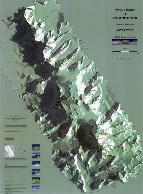
- D. Gildea and C. Rada. Vinson Massif and the Sentinel Range. Scale 1:50 000 topographic map. Omega Foundation, 2007
- Antarctic Digital Database (ADD). Scale 1:250000 topographic map of Antarctica. Scientific Committee on Antarctic Research (SCAR). Since 1993, regularly updated
See also[edit]
Gallery[edit]
-
-
 Location of Sentinel Range in West Antarctica
 -
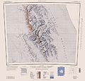 USGS map of central and southern Sentinel Range


Notes[edit]
- ^ a b c d e Reference Elevation Model of Antarctica. Polar Geospatial Center. University of Minnesota, 2019
- ^ a b c Opalchenie Peak SCAR Composite Antarctic Gazetteer
- ^ R. Anderson. The Rolex Ridge solo, Mt. Vinson, Antarctica. Explore 7 Summits website, 27 February 2019
- ^ R. Anderson. Mt. Vinson, southwest face, first ascent to Double003. American Alpine Journal, 2003. pp. 332-333
References[edit]
- Opalchenie Peak SCAR Composite Antarctic Gazetteer
- Bulgarian Antarctic Gazetteer Antarctic Place-names Commission (in Bulgarian)
- Basic data (in English)
External links[edit]
- Opalchenie Peak. Adjusted Copernix satellite image
- Opalchenie Peak on AADC website
This article includes information from the Antarctic Place-names Commission of Bulgaria which is used with permission.

This Ellsworth Land location article is a stub. You can help Wikipedia by expanding it. |