
Mount St. Ursula
| Mount St. Ursula | |
|---|---|
 Mount St. Ursula from Kotlje | |
| Highest point | |
| Elevation | 1,699 m (5,574 ft) |
| Coordinates | 46°29′5.09″N 14°57′55.95″E / 46.4847472°N 14.9655417°E |
| Naming | |
| Native name | Uršlja gora (Slovene) |
| Geography | |
 Mount St. Ursula northern Slovenia | |
| Parent range | Karawanks |
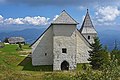
Mount St. Ursula (Slovene: Uršlja gora) or Plešivec (1,699 metres or 5,574 feet) is the easternmost peak of the Karawanks. It lies between the towns of Slovenj Gradec and Črna na Koroškem. There are three villages on the slopes of the mountain: Uršlja Gora, Podgora, and Zgornji Razbor. The mountain offers a panoramic view towards all of Carinthia, the Kozjak Mountains, and the Kamnik–Savinja Alps. Below the peak of Mount St. Ursula stands the Gothic St. Ursula's Church (which gives the mountain its name and is the highest-standing church in Slovenia), a TV mast tower, a mountain lodge (the Mount St. Ursula Lodge, Dom na Uršlji gori), 1,670 m or 5,480 ft), and a monument to the soldiers fallen in World War I.[citation needed]. The name Plešivec (literally, 'the bald one') derives from its grey limestone peak.
Starting points[edit]
- Postmen's Lodge Below Plešivec (Poštarski dom pod Plešivcem) (2 h 30 min)
- Naravske Fallows Hut (Koča na Naravskih ledinah) (1 h 45 min)
- The Gate - by road (45 min)
- Lake Ivartnik (Ivarčko jezero) (2 h 30 min)
- Ciganija (2 h 30 min)
Mast tower[edit]

The Radiotelevizija Slovenija mast tower was built in 1962. The site allows for optimal TV broadcasting towards Carinthia and Styria. It has also been used by firemen, the police, mountain rescuers, and others.
Climate[edit]
Mount St. Ursula (Uršlja gora) has a subarctic climate (Köppen Dfc).
| Climate data for Uršlja gora 1981-2010 (1696m) | |||||||||||||
|---|---|---|---|---|---|---|---|---|---|---|---|---|---|
| Month | Jan | Feb | Mar | Apr | May | Jun | Jul | Aug | Sep | Oct | Nov | Dec | Year |
| Mean daily maximum °C (°F) | −1.6 (29.1) |
−1.2 (29.8) |
1.0 (33.8) |
4.5 (40.1) |
9.9 (49.8) |
12.9 (55.2) |
15.5 (59.9) |
15.3 (59.5) |
11.4 (52.5) |
8.0 (46.4) |
2.9 (37.2) |
−0.7 (30.7) |
6.5 (43.7) |
| Daily mean °C (°F) | −4.3 (24.3) |
−4.6 (23.7) |
−2.0 (28.4) |
1.2 (34.2) |
6.3 (43.3) |
9.5 (49.1) |
11.7 (53.1) |
11.7 (53.1) |
8.2 (46.8) |
5.1 (41.2) |
0.3 (32.5) |
−3.1 (26.4) |
3.3 (38.0) |
| Mean daily minimum °C (°F) | −6.4 (20.5) |
−7.3 (18.9) |
−4.6 (23.7) |
−1.6 (29.1) |
3.5 (38.3) |
6.4 (43.5) |
8.6 (47.5) |
9.0 (48.2) |
6.0 (42.8) |
2.7 (36.9) |
−1.8 (28.8) |
−5.3 (22.5) |
0.8 (33.4) |
| Source: Slovenian Environment Agency (ARSO)[1] | |||||||||||||
Gallery[edit]
-
 View from Mount St. Ursula, to the right stands the Plešivec radio mast tower
 -
 The mountain lodge and the church
 -
 Saint Ursula's Church


References[edit]
- ^ "Uršlja Gora Climate Normals 1981-2020" (PDF). ARSO. Retrieved 25 August 2023.
- Javornik, Marjan. Enciklopedija Slovenije.Mladinska knjiga, Ljubljana 1987–2002. Pg. 100. COBISS 17411.
- Jurij, Pivka in Galun, Nataša. Štajerska. Sidarta, Ljubljana, 2001. Pp. 61–63. COBISS 113005312
- Radovanovič, Sašo. Bevc Varl, Valentina in Žiberna, Igor. Koroška : A-Ž : priročnik za popotnika in poslovnega človeka. Pomurska založba. Murska Sobota, 1999. Pp. 141, 142. COBISS 43634689