Mirik, Azerbaijan
Mirik | |
|---|---|
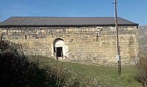
 Armenian church of Surb Astvatsatsin in Mirik | |
| Coordinates: 39°41′19″N 46°19′57″E / 39.68861°N 46.33250°E | |
| Country | |
| District | Lachin |
| Population (2015)[1] | |
| • Total | 179 |
| Time zone | UTC+4 (AZT) |
| Area code | +994 26 |
Mirik (Armenian: Միրիկ) is a village in the Lachin District of Azerbaijan.
History[edit]

The village came under the control of ethnic Armenian forces during the First Nagorno-Karabakh War in the early 1990s. The village subsequently became part of the breakaway Republic of Artsakh as part of its Kashatagh Province, located in the Armenian-occupied territories surrounding Nagorno-Karabakh. It was returned to Azerbaijan as part of the 2020 Nagorno-Karabakh ceasefire agreement.
Historical heritage sites[edit]
Historical heritage sites in and around the village include the church of Surb Astvatsatsin (Armenian: Սուրբ Աստվածածին, lit. 'Holy Mother of God') built in 1682, and tombstones from the 17th century.[1]
Geography[edit]
The village is located on the left bank of the Minkend branch of the Hakari River, 2 km to the west of the village of Bozlu, at an altitude of 1,440-1,520 meters above sea level. Rivers that flow through the village include the rivers of Mirik, Dalikli, and the Minkend branch of the Hakari River.
References[edit]
- ^ a b Hakob Ghahramanyan. "Directory of socio-economic characteristics of NKR administrative-territorial units (2015)".


