
Micăsasa
Micăsasa | |
|---|---|
 Catholic church in Micăsasa | |
 Location in Sibiu County | |
 Micăsasa Location in Romania | |
| Coordinates: 46°5′N 24°7′E / 46.083°N 24.117°E | |
| Country | Romania |
| County | Sibiu |
| Government | |
| • Mayor (2020–2024) | Timotei Păcurar (USR) |
| Area | 71.38 km2 (27.56 sq mi) |
| Population (2021-12-01)[1] | 1,698 |
| • Density | 24/km2 (62/sq mi) |
| Time zone | EET/EEST (UTC+2/+3) |
| Postal code | 557145 |
| Area code | +40 x59 |
| Vehicle reg. | SB |
Micăsasa (German: Feigendorf; Hungarian: Mikeszásza) is a commune located in Sibiu County, Transylvania, Romania. It is composed of four villages: Chesler, Micăsasa, Țapu, and Văleni. Micăsasa and Țapu villages have fortified churches.
The route of the Via Transilvanica long-distance trail passes through the village of Micăsasa.[2]
At the 2011 census, 93.4% of inhabitants were Romanians, 4.4% Hungarians, 1.5% Roma, and 0.6% Germans.
| In Romanian | In German | In Hungarian |
|---|---|---|
| Chesler | Kesseln | Keszlér |
| Micăsasa | Feigendorf | Mikeszásza |
| Țapu | Abtsdorf an der Kokel | Csicsóholdvilág |
| Văleni | Huruba |
References[edit]
- ^ "Populaţia rezidentă după grupa de vârstă, pe județe și municipii, orașe, comune, la 1 decembrie 2021" (XLS). National Institute of Statistics.
- ^ "Terra Saxonum | Via Transilvanica". www.viatransilvanica.com (in Romanian). Retrieved 2023-08-14.
-
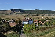
 Chesler
 -
 Țapu
Țapu -
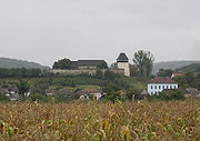 Fortified church of Țapu


This Sibiu County location article is a stub. You can help Wikipedia by expanding it. |