
List of extreme summits of the Rocky Mountains

This article comprises four sortable tables of mountain summits of the Rocky Mountains of North America that are the higher than any other point north or south of their latitude or east or west their longitude in those mountains.
The summit of a mountain or hill may be measured in three principal ways:
- The topographic elevation of a summit measures the height of the summit above a geodetic sea level.[1][2]
- The topographic prominence of a summit is a measure of how high the summit rises above its surroundings.[3][4][2]
- The topographic isolation (or radius of dominance) of a summit measures how far the summit lies from its nearest point of equal elevation.[5]
Northernmost high summits[edit]
Southernmost high summits[edit]
Easternmost high summits[edit]
Westernmost high summits[edit]
Gallery[edit]
-
 Mount Elbert in the Sawatch Range is the highest summit of the Rocky Mountains and the US State of Colorado.
 -
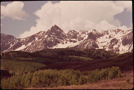
 Mount Massive in the Sawatch Range of Colorado is the second highest summit of the Rocky Mountains.
 -
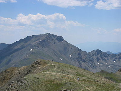 Mount Harvard is the highest summit of the Collegiate Peaks of Colorado.
 -
 Blanca Peak is the highest summit of the Sangre de Cristo Mountains of Colorado.
 -
 Uncompahgre Peak is the highest summit of the San Juan Mountains of Colorado.
 -
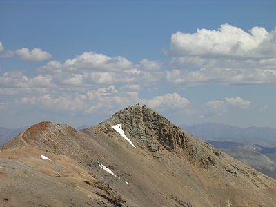 Mount Lincoln is the highest summit of the Mosquito Range of Colorado.
 -
 Grays Peak is the highest summit of the Front Range of Colorado and the highest point on the Continental Divide in North America.
 -
 Longs Peak is the highest summit of the northern Front Range of Colorado.
 -
-
 Pikes Peak in Colorado was the inspiration for America the Beautiful.
 -
 Culebra Peak in Colorado is the highest summit of the Culebra Range.
 -
 This photograph of the legendary Mount of the Holy Cross in Colorado was taken by William Henry Jackson in 1874.
 -
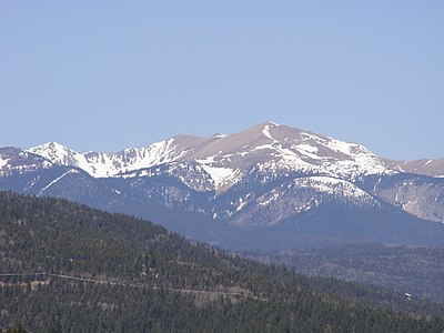
 Gannett Peak is the highest summit of the Wind River Range, the US State of Wyoming, and the Central Rocky Mountains.
 -
 Grand Teton is the highest summit of the Teton Range of Wyoming.
 -
 Cloud Peak is the highest summit of the Big Horn Mountains of Wyoming.
 -
-
 Truchas Peak is the highest summit of the Santa Fe Mountains of New Mexico.
 -
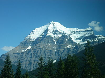 Mount Robson in British Columbia is the highest summit of the Canadian Rockies and the most prominent summit of the Rocky Mountains.
 -
 Santa Fe Baldy in New Mexico is the southernmost 3000-meter (9843-foot) summit of the Rocky Mountains.

_-_2006-07-16.jpg)


See also[edit]
- Rocky Mountains
- List of mountain peaks of North America
- Physical geography
Notes[edit]
- ^ a b The summit of Sentinel Peak is the highest point of the Murray Range.
- ^ a b Sentinel Peak is the northernmost and westernmost 2000-meter (6562-foot) summit of the Rocky Mountains.
- ^ Mount Ida is the northernmost 3000-meter (9843-foot) summit and ultra-prominent summit of the Rocky Mountains.
- ^ a b Mount Sir Alexander is the northernmost and westernmost 3000-meter (9843-foot) summit and ultra-prominent summit of the Rocky Mountains.
- ^ a b Mount Chown is the northernmost and westernmost summit of its elevation in the Rocky Mountains.
- ^ a b Whitehorn Mountain is the northernmost and westernmost summit of its elevation in the Rocky Mountains.
- ^ a b The summit of Mount Robson is the highest point of the Canadian Rockies.
- ^ a b Mount Robson is the easternmost summit of its elevation in Canada and the northernmost and westernmost summit of its elevation in the Rocky Mountains.
- ^ The summit of Cloud Peak is the highest point of the Bighorn Mountains.
- ^ Cloud Peak is the northernmost 4000-meter (13,123-foot) summit of the Rocky Mountains.
- ^ a b The summit of Grand Teton is the highest point of the Teton Range.
- ^ a b Grand Teton is the northernmost and westernmost 4000-meter (13,123-foot) summit of the Rocky Mountains.
- ^ a b The summit of Gannett Peak is the highest point of the Wind River Range, the U.S. State of Wyoming, and the central Rocky Mountains.
- ^ a b Gannett Peak is the northernmost and westernmost summit of its elevation in the Rocky Mountains.
- ^ The summit of Longs Peak is the highest point of the northern Front Range.
- ^ Longs Peak is the northernmost 14,000-foot (4267-meter) summit of the Rocky Mountains.
- ^ The summit of Grays Peak is the highest point of the Front Range and the Continental Divide in North America.
- ^ Grays Peak is the northernmost summit of its elevation in the Rocky Mountains.
- ^ The summit of Mount Lincoln is the highest point of the Mosquito Range and the entire Missouri River drainage basin.
- ^ Mount Lincoln is the northernmost summit of its elevation in the Rocky Mountains.
- ^ a b Mount Massive is the second highest major summit of the Rocky Mountains.
- ^ a b The elevation of Mount Massive includes an adjustment of +2.087 m (6.85 ft) from NGVD 29 to NAVD 88.
- ^ a b c d The summit of Mount Elbert is the highest point of the U.S. State of Colorado, the Rocky Mountains of North America, and the entire Mississippi River drainage basin.
- ^ Santa Fe Baldy is the southernmost 3000-meter (9843-foot) summit of the Rocky Mountains.
- ^ The summit of Truchas Peak is the highest point of the Santa Fe Mountains.
- ^ Truchas Peak is the southernmost summit of its elevation in the Rocky Mountains.
- ^ The summit of Wheeler Peak is the highest point of the Taos Mountains and the U.S. State of New Mexico.
- ^ Wheeler Peak is the southernmost 4000-meter (13,123-foot) summit of the Rocky Mountains.
- ^ The summit of Culebra Peak is the highest point of the Culebra Range.
- ^ Culebra Peak is the southernmost 14,000-foot (4267-meter) summit of the Rocky Mountains.
- ^ The elevation of Culebra Peak includes an adjustment of +1.74 m (5.71 ft) from NGVD 29 to NAVD 88.
- ^ a b The summit of Blanca Peak is the highest point of the Sangre de Cristo Mountains and the entire Rio Grande drainage basin.
- ^ a b Blanca Peak is the southernmost ultra-prominent summit of the Rocky Mountains.
- ^ a b The elevation of Blanca Peak includes an adjustment of +1.755 m (5.76 ft) from NGVD 29 to NAVD 88.
- ^ a b The summit of Mount Harvard is the highest point of the Collegiate Peaks.
- ^ a b Mount Harvard is the southernmost and easternmost summit of its elevation in the Rocky Mountains.
- ^ The summit of Fishers Peak is the highest point of Raton Mesa.
- ^ Fishers Peak is the easternmost summit of its elevation in the Rocky Mountains and the United States.
- ^ East Spanish Peak is the easternmost 3000-meter (9843-foot) summit of the Rocky Mountains and the United States.
- ^ The elevation of East Spanish Peak includes an adjustment of +1.372 m (4.5 ft) from NGVD 29 to NAVD 88.
- ^ West Spanish Peak is the easternmost 4000-meter (13,123-foot) summit of the Rocky Mountains and the United States.
- ^ The elevation of West Spanish Peak includes an adjustment of +1.468 m (4.82 ft) from NGVD 29 to NAVD 88.
- ^ Pikes Peak is the easternmost 14,000-foot (4267-meter) summit and ultra-prominent summit of the Rocky Mountains. Pikes Peak was the inspiration for the lyrics of America the Beautiful.
- ^ The summit of Mount Wilson is the highest point of the San Miguel Mountains.
- ^ Mount Wilson is the westernmost summit of its elevation in the Rocky Mountains.
- ^ The elevation of Mount Wilson includes an adjustment of +1.899 m (6.23 ft) from NGVD 29 to NAVD 88.
- ^ The summit of Uncompahgre Peak is the highest point of the San Juan Mountains and the entire Gulf of California drainage basin.
- ^ Uncompahgre Peak is the westernmost summit of its elevation in the Rocky Mountains.
References[edit]
- ^ All elevations in the 48 states of the contiguous United States include an elevation adjustment from the National Geodetic Vertical Datum of 1929 (NGVD 29) to the North American Vertical Datum of 1988 (NAVD 88). For further information, please see this United States National Geodetic Survey note.
- ^ a b If the elevation or prominence of a summit is calculated as a range of values, the arithmetic mean is shown.
- ^ The topographic prominence of a summit is the topographic elevation difference between the summit and its highest or key col to a higher summit. The summit may be near its key col or quite far away. The key col for Denali in Alaska is the Isthmus of Rivas in Nicaragua, 7642 kilometers (4749 miles) away.
- ^ This article defines a significant summit as a summit with at least 100 meters (328.1 feet) of topographic prominence, and a major summit as a summit with at least 500 meters (1640 feet) of topographic prominence. All summits in this article have at least 500 meters of topographic prominence. An ultra-prominent summit is a summit with at least 1500 meters (4921 feet) of topographic prominence.
- ^ The topographic isolation of a summit is the great-circle distance to its nearest point of equal elevation.
- ^ a b "Sentinel Peak". Peakbagger.com. Retrieved May 4, 2016.
- ^ a b "Sentinel Peak". Bivouac.com. Retrieved May 4, 2016.
- ^ "Mount Ida". Peakbagger.com. Retrieved May 4, 2016.
- ^ "Mount Ida". Bivouac.com. Retrieved May 4, 2016.
- ^ a b "Mount Sir Alexander". Peakbagger.com. Retrieved May 4, 2016.
- ^ a b "Mount Sir Alexander". Bivouac.com. Retrieved May 4, 2016.
- ^ a b "Mount Chown". Peakbagger.com. Retrieved May 4, 2016.
- ^ a b "Mount Chown". Bivouac.com. Retrieved May 4, 2016.
- ^ a b "Whitehorn Mountain". Peakbagger.com. Retrieved May 4, 2016.
- ^ a b "Whitehorn Mountain". Bivouac.com. Retrieved May 4, 2016.
- ^ a b "Mount Robson". Peakbagger.com. Retrieved May 4, 2016.
- ^ a b "Mount Robson". Bivouac.com. Retrieved May 4, 2016.
- ^ "CLOUD PEAK". Datasheet for NGS Station PW0524. U.S. National Geodetic Survey. Retrieved May 4, 2016.
- ^ "Cloud Peak". Peakbagger.com. Retrieved May 4, 2016.
- ^ "Cloud Peak". Bivouac.com. Retrieved May 4, 2016.
- ^ a b "GRAND TETON". Datasheet for NGS Station OX0838. U.S. National Geodetic Survey. Retrieved May 4, 2016.
- ^ a b "Grand Teton". Peakbagger.com. Retrieved May 4, 2016.
- ^ a b "Grand Teton". Bivouac.com. Retrieved May 4, 2016.
- ^ a b "GANNETT PEAK CAIRN". Datasheet for NGS Station OW0356. U.S. National Geodetic Survey. Retrieved May 4, 2016.
- ^ a b "Gannett Peak". Peakbagger.com. Retrieved May 4, 2016.
- ^ a b "Gannett Peak". Bivouac.com. Retrieved May 4, 2016.
- ^ "LONGS PEAK". Datasheet for NGS Station LL1346. U.S. National Geodetic Survey. Retrieved May 4, 2016.
- ^ "Longs Peak". Peakbagger.com. Retrieved May 4, 2016.
- ^ "Longs Peak". Bivouac.com. Retrieved May 4, 2016.
- ^ "GRAYS PEAK". Datasheet for NGS Station KK2036. U.S. National Geodetic Survey. Retrieved May 4, 2016.
- ^ "Grays Peak". Peakbagger.com. Retrieved May 4, 2016.
- ^ "Grays Peak". Bivouac.com. Retrieved May 4, 2016.
- ^ "MT LINCOLN". Datasheet for NGS Station KL0627. U.S. National Geodetic Survey. Retrieved May 4, 2016.
- ^ "Mount Lincoln". Peakbagger.com. Retrieved May 4, 2016.
- ^ "Mount Lincoln". Bivouac.com. Retrieved May 4, 2016.
- ^ a b "MOUNT MASSIVE CAIRN". Datasheet for NGS Station KL0640. U.S. National Geodetic Survey. Retrieved May 4, 2016.
- ^ a b "Mount Massive". Peakbagger.com. Retrieved May 4, 2016.
- ^ a b "Mount Massive". Bivouac.com. Retrieved May 4, 2016.
- ^ a b c d "MOUNT ELBERT". Datasheet for NGS Station KL0637. U.S. National Geodetic Survey. Retrieved May 4, 2016.
- ^ a b c d "Mount Elbert". Peakbagger.com. Retrieved May 4, 2016.
- ^ a b c d "Mount Elbert". Bivouac.com. Retrieved May 4, 2016.
- ^ "SANTA FE BALDY". Datasheet for NGS Station FN0726. U.S. National Geodetic Survey. Retrieved May 4, 2016.
- ^ "Santa Fe Baldy". Peakbagger.com. Retrieved May 4, 2016.
- ^ "Santa Fe Baldy". Bivouac.com. Retrieved May 4, 2016.
- ^ "TRUCHAS". Datasheet for NGS Station FN0666. U.S. National Geodetic Survey. Retrieved May 4, 2016.
- ^ "Truchas Peak". Peakbagger.com. Retrieved May 4, 2016.
- ^ "Truchas Peak". Bivouac.com. Retrieved May 4, 2016.
- ^ "WHEELER". Datasheet for NGS Station GM0779. U.S. National Geodetic Survey. Retrieved May 4, 2016.
- ^ "Wheeler Peak". Peakbagger.com. Retrieved May 4, 2016.
- ^ "Wheeler Peak". Bivouac.com. Retrieved May 4, 2016.
- ^ "Culebra Peak". Peakbagger.com. Retrieved May 4, 2016.
- ^ "Culebra Peak". Bivouac.com. Retrieved May 4, 2016.
- ^ a b "Blanca Peak". Peakbagger.com. Retrieved May 4, 2016.
- ^ a b "Blanca Peak". Bivouac.com. Retrieved May 4, 2016.
- ^ a b "HARVARD". Datasheet for NGS Station JL0879. U.S. National Geodetic Survey. Retrieved May 4, 2016.
- ^ a b "Mount Harvard". Peakbagger.com. Retrieved May 4, 2016.
- ^ a b "Mount Harvard". Bivouac.com. Retrieved May 4, 2016.
- ^ "FISHER PEAK". Datasheet for NGS Station HK0441. U.S. National Geodetic Survey. Retrieved May 4, 2016.
- ^ "Fishers Peak". Peakbagger.com. Retrieved May 4, 2016.
- ^ "Fishers Peak". Bivouac.com. Retrieved May 4, 2016.
- ^ "EAST SPANISH PEAK CAIRN". Datasheet for NGS Station HK0488. U.S. National Geodetic Survey. Retrieved May 4, 2016.
- ^ "East Spanish Peak". Peakbagger.com. Retrieved May 4, 2016.
- ^ "East Spanish Peak". Bivouac.com. Retrieved May 4, 2016.
- ^ "West Spanish Peak". Peakbagger.com. Retrieved May 4, 2016.
- ^ "West Spanish Peak". Bivouac.com. Retrieved May 4, 2016.
- ^ "PIKES PEAK". Datasheet for NGS Station JK1242. U.S. National Geodetic Survey. Retrieved May 4, 2016.
- ^ "Pikes Peak". Peakbagger.com. Retrieved May 4, 2016.
- ^ "Pikes Peak". Bivouac.com. Retrieved May 4, 2016.
- ^ "Mount Wilson". Peakbagger.com. Retrieved May 4, 2016.
- ^ "Mount Wilson". Bivouac.com. Retrieved May 4, 2016.
- ^ "UNCOMPAHGRE". Datasheet for NGS Station JL0798. U.S. National Geodetic Survey. Retrieved May 4, 2016.
- ^ "Uncompahgre Peak". Peakbagger.com. Retrieved May 4, 2016.
- ^ "Uncompahgre Peak". Bivouac.com. Retrieved May 4, 2016.
External links[edit]
Rocky Mountains at Wikipedia's sister projects
 Definitions from Wiktionary
 Media from Commons
 News from Wikinews
 Quotations from Wikiquote
 Texts from Wikisource
 Textbooks from Wikibooks
 Resources from Wikiversity