
Letca
Letca | |
|---|---|
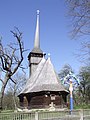
 Wooden Church in Letca | |
 Location in Sălaj County | |
 Letca Location in Romania | |
| Coordinates: 47°20′04″N 23°27′18″E / 47.33444°N 23.45500°E | |
| Country | Romania |
| County | Sălaj |
| Government | |
| • Mayor (2020–2024) | Dorel Liviu Man[1] (PSD) |
| Area | 60.50 km2 (23.36 sq mi) |
| Population (2021-12-01)[2] | 1,625 |
| • Density | 27/km2 (70/sq mi) |
| Time zone | EET/EEST (UTC+2/+3) |
| Vehicle reg. | SJ |
| Website | www.comunaletca.ro |
Letca (Hungarian: Létka) is a commune located in Sălaj County, Transylvania, Romania. It is composed of nine villages: Ciula (Gyulaszeg), Cuciulat (Kocsoládfalva), Cozla (Kecskés), Letca, Lemniu (Lemény), Purcăreț (Pórkerec), Șoimușeni (Kővársolymos), Toplița (Szamoshéviz) and Vălișoara (Dióspatak).
Villages[edit]
Purcăreț village had 139 inhabitants at the 2002 census. It is located on the right bank of the Someș River, and borders Maramureș County.[citation needed] It is first attested in a document of 1543, referred to as Porkerecz. Other documents refer to it as Porkoricza (1553), Pwrkerecz, Purkerech (1566), Purkeritz (1733), Porkeresty (1750), Purkeretz (1760-1762), Purkuretz (1830), Purkuretzi (1850), Purkerecz, Purcureți (1854), and finally Purcăreț (1966).[3] The noble family Lazăr of Purcăreț originates from this village.[4] The Wooden Church from Purcăreț is traditionally dated from 1698, although the Culture Ministry cites 1740 and researcher Ioana Cristache-Panait says it is from the first half of the 19th century.[citation needed]
Sights[edit]
- Wooden Church “St. Mary” in Letca, built in the 17th century (1665), historic monument
- Wooden Church “St. Archangels” in Letca, built in the 18th century, historic monument
- Wooden Church in Purcăreț, built in the 19th century, historic monument
- Wooden Church in Șoimușeni, built in the 19th century, historic monument
- Wooden Church in Toplița, built in the 19th century (1864), historic monument
Images gallery[edit]
-
 Wooden church in Cuciulat
 -
 Wooden church in Șoimușeni
 -
 Wooden church in Purcăreț
 -
 Wooden church in Toplița


References[edit]
- ^ "Results of the 2020 local elections". Central Electoral Bureau. Retrieved 14 June 2021.
- ^ "Populaţia rezidentă după grupa de vârstă, pe județe și municipii, orașe, comune, la 1 decembrie 2021" (XLS). National Institute of Statistics.
- ^ Chendre-Roman, Gheorghe. Dicţionar etimologic al localităților din județul Sălaj. Editura Silvana, Editura Caiete Silvane, 2006, ISBN 973-7817-41-9
- ^ National Archives of Romania, Sălaj County Branch, Lazăr of Purcăreț family fund, inventory number 131 (1720-1945)

This Sălaj County location article is a stub. You can help Wikipedia by expanding it. |