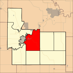
Jefferson Township, Geary County, Kansas
Jefferson Township | |
|---|---|
 Location in Geary County | |
| Coordinates: 39°00′02″N 096°45′41″W / 39.00056°N 96.76139°W | |
| Country | United States |
| State | Kansas |
| County | Geary |
| Area | |
| • Total | 48.44 sq mi (125.46 km2) |
| • Land | 47.69 sq mi (123.51 km2) |
| • Water | 0.75 sq mi (1.95 km2) 1.55% |
| Elevation | 1,289 ft (393 m) |
| Population (2000) | |
| • Total | 1,651 |
| • Density | 34.6/sq mi (13.4/km2) |
| GNIS feature ID | 0476710 |
Jefferson Township is a township in Geary County, Kansas, USA. As of the 2000 census, its population was 1,651.
History[edit]
Jefferson Township was established in 1878. It was named for Thomas Jefferson.[1]
Geography[edit]
Jefferson Township covers an area of 48.44 square miles (125.5 km2) and contains one incorporated settlement, Grandview Plaza. According to the USGS, it contains two cemeteries: Fairview and Rosey.
Whiskey Lake is within this township. The streams of Clarks Creek, Davis Creek, Dry Creek, Franks Creek and Humboldt Creek run through this township.
Transportation[edit]
Jefferson Township contains one airport or landing strip, Marshall Airfield.
References[edit]
- ^ "Geary County History (archived)". Geary County Historical Society. Archived from the original on October 12, 2013. Retrieved June 10, 2014.
Further reading[edit]
External links[edit]

