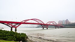
Guandu Bridge
You can help expand this article with text translated from the corresponding article in Chinese. (August 2012) Click [show] for important translation instructions.
|
Guandu Bridge 關渡大橋 | |
|---|---|
 | |
| Coordinates | 25°07′32″N 121°27′26″E / 25.1256°N 121.4572°E |
| Carries | |
| Crosses | Tamsui River |
| Locale | New Taipei, Taiwan |
| Characteristics | |
| Design | Arch bridge |
| Total length | 809 metres (2,654 ft) [1] |
| Width | 19 metres (62 ft) [1] |
| Height | 87.8 metres (288 ft) [1] |
| No. of spans | 5 |
| Piers in water | 4 |
| History | |
| Designer | Tung-Yen Lin |
| Construction start | April 1980 |
| Construction end | October 1983 |
| Opened | 31 October 1983 |
| Location | |
 | |
25°07′32″N 121°27′26″E / 25.12556°N 121.45722°E
The Guandu Bridge (Chinese: 關渡大橋; pinyin: Guāndù Dàqiáo; Pe̍h-ōe-jī: Koan To Toa Kio) is a bridge in New Taipei, Taiwan. It spans over the Tamsui River and links Bali District and Tamsui District. The bridge is a 165 meters long through arch bridge designed by Tung-Yen Lin under T.Y. Lin International. It now carries the Provincial Highway 15.[2][3]
History[edit]
Bridge construction started in April 1980 and was completed on 31 October 1983.
Transportation[edit]
The bridge is accessible within walking distance west of Guandu Station of Taipei Metro.
See also[edit]
References[edit]
- ^ a b c "特色橋梁調查表-關渡橋". Taiwan Ministry of Transportation and Communications.
- ^ "T.Y. Lin International Group - Projects - Kuandu Bridge".
- ^ "Second phase of new Danjiang Bridge over Tamsui River begins - The China Post". Archived from the original on 2016-02-23.
Wikimedia Commons has media related to Guandu Bridge.
