
Gaspésie National Park
| Parc national de la Gaspésie | |
|---|---|
 Summit of Mount Jacques-Cartier | |
 Location in Quebec | |
| Location | La Haute-Gaspésie and La Matanie RCMs, Quebec, Canada |
| Nearest city | Sainte-Anne-des-Monts |
| Coordinates | 48°56′00″N 66°14′00″W / 48.93333°N 66.23333°W |
| Area | 80,200 hectares[1] |
| Established | November 25, 1981[2] |
| Governing body | Sépaq |
Gaspésie National Park (French: Parc national de la Gaspésie) is a provincial park located south of the town of Sainte-Anne-des-Monts, Quebec, Canada in the inland of the Gaspé peninsula. The park contains the highest peak of the Appalachian Mountains in Canada, Mont Jacques-Cartier, 1,270 metres (4,170 ft) above sea level. In addition, the park contains the only population of Caribou found south of the Saint Lawrence River in Canada.

Geology[edit]
There are two major and geologically distinct mountain ranges in the park. The first one, to the west of the St-Anne's River, is the Chic-Choc Mountain range. This range is 600 million years old and was mainly formed from underwater volcanic activity.
In contrast, the McGerrigle Mountains are much younger, only 380 million years. From the depths of the sea, magma oozed through cracks in the Earth's crust and then cooled, resulting in a large underground granite batholith. Over time, the softer sedimentary rocks above the batholith eroded away, leaving only the resistant granite. Mont Jacques-Cartier is part of this range.
Climate[edit]
Owing the area's elevation and proximity to the Saint Lawrence River, the climate of the park is very different from the lowlands of Quebec. Mount Logan, at an altitude of 1,150 m (3,770 ft), has an average annual temperature of −3.6 °C (25.5 °F). This low temperature, combined with the lower pressure at high altitude, causes moisture to condense and fall as rain or snow; in fact, these mountains are the wettest region of Quebec.[3]
Gallery[edit]
-
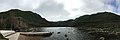 Lac aux Américains
 -
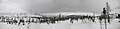 Mountains, winter 2008-2009
 -
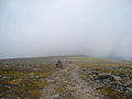 Mount Jacques-Cartier summit
 -
 Grande Cuve, Mount Albert
 -
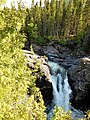 Sainte-Anne waterfall
 -
 Lake on the plateau at the summit of Mount Albert


See also[edit]
- List of Quebec provincial & national parks
- National Parks of Canada
- List of National Parks of Canada
External links[edit]
References[edit]
- ^ - Registre des aires protégées au Québec Archived December 12, 2013, at the Wayback Machine - Ministère du Développement durable, de l’Environnement et des Parcs du Québec, Retrieved on September 19, 2007
- ^ Existing Park - Ministère du Développement durable, de l’Environnement et des Parcs, Retrieved on September 19, 2007
- ^ "Parc National de la Gaspésie" (in Canadian French). Sépaq. Retrieved December 17, 2022.
This Quebec location article is a stub. You can help Wikipedia by expanding it. |
This Canadian protected area related article is a stub. You can help Wikipedia by expanding it. |