
File:World metro system cities.png

Size of this preview: 800 × 409 pixels. Other resolutions: 320 × 164 pixels | 640 × 327 pixels | 1,024 × 524 pixels | 1,983 × 1,014 pixels.
Original file (1,983 × 1,014 pixels, file size: 279 KB, MIME type: image/png)
| This is a file from the Wikimedia Commons. Information from its description page there is shown below. Commons is a freely licensed media file repository. You can help. |

Summary
| Description |
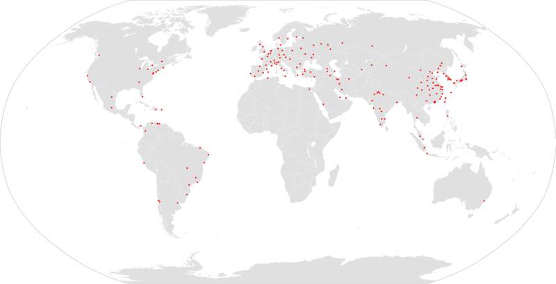
English: A map showing all the world's metro or subway systems. |
| Date | |
| Source | Own work |
| Author | Interchange88 |
Licensing
This media file is in the public domain in the United States. This applies to U.S. works where the copyright has expired, often because its first publication occurred prior to January 1, 1929, and if not then due to lack of notice or renewal. See this page for further explanation.
|
 | |
 |
This image might not be in the public domain outside of the United States; this especially applies in the countries and areas that do not apply the rule of the shorter term for US works, such as Canada, Mainland China (not Hong Kong or Macao), Germany, Mexico, and Switzerland. The creator and year of publication are essential information and must be provided. See Wikipedia:Public domain and Wikipedia:Copyrights for more details.
|
File history
Click on a date/time to view the file as it appeared at that time.
| Date/Time | Thumbnail | Dimensions | User | Comment | |
|---|---|---|---|---|---|
| current | 11:20, 12 March 2023 | | 1,983 × 1,014 (279 KB) | Rizorius | Karaj metro is opened |
| 23:14, 17 June 2022 |  | 1,983 × 1,014 (256 KB) | HerrMay | Frankfurt U-Bahn is a Light rail, not a Metro System | |
| 00:23, 10 June 2020 |  | 1,983 × 1,014 (277 KB) | Maphobbyist | Update: Honhot Metro was opened on 29 December 2019. | |
| 19:37, 11 December 2019 |  | 1,983 × 1,014 (277 KB) | Maphobbyist | Update for the Chinese cities. | |
| 16:29, 10 December 2019 |  | 1,983 × 1,014 (277 KB) | Maphobbyist | Update: China has three new metro networks: Changzhou, Xuzhou and Macau. | |
| 21:48, 29 July 2019 |  | 1,983 × 1,014 (277 KB) | Maphobbyist | Update: Wenzhou Metro was opened on 23 January 2019. | |
| 20:54, 10 July 2019 |  | 2,000 × 1,015 (272 KB) | Maphobbyist | Added Taoyuan metro system which was forgotten and which is linked to Taipei Metro. | |
| 20:37, 1 July 2019 |  | 2,000 × 1,015 (277 KB) | Maphobbyist | Added Sao Paulo and Salvador metro systems which were forgotten. Corrected geographical positions of Fortaleza and Brasilia. Removed Casablanca because it still has no metro. | |
| 19:26, 25 June 2019 |  | 2,000 × 1,015 (277 KB) | Maphobbyist | Update: China has two new metro networks: Jinan and Lanzhou. | |
| 16:19, 26 May 2019 |  | 2,000 × 1,015 (277 KB) | Maphobbyist | Update: Sydney Metro was opened on 26 May 2019. |
File usage
The following pages on the English Wikipedia use this file (pages on other projects are not listed):
Global file usage
The following other wikis use this file:
- Usage on ab.wikipedia.org
- Usage on ar.wikipedia.org
- Usage on be.wikipedia.org
- Usage on ca.wikipedia.org
- Usage on hu.wikipedia.org
- Usage on hy.wikipedia.org
- Usage on id.wikipedia.org
- Usage on ja.wikipedia.org
- Usage on ko.wikipedia.org
- Usage on mhr.wikipedia.org
- Usage on ms.wikipedia.org
- Usage on pl.wikipedia.org
- Usage on pnb.wikipedia.org
- Usage on pt.wikipedia.org
- Usage on ru.wikipedia.org
- Usage on sk.wikipedia.org
- Usage on sv.wikipedia.org
- Usage on th.wikipedia.org
- Usage on tt.wikipedia.org
- Usage on ur.wikipedia.org
- Usage on uz.wikipedia.org
- Usage on zh.wikipedia.org