
File:United Kingdom ESA361630.tiff

Original file (4,000 × 3,496 pixels, file size: 80.04 MB, MIME type: image/tiff)
| This is a file from the Wikimedia Commons. Information from its description page there is shown below. Commons is a freely licensed media file repository. You can help. |
Summary
| Description |
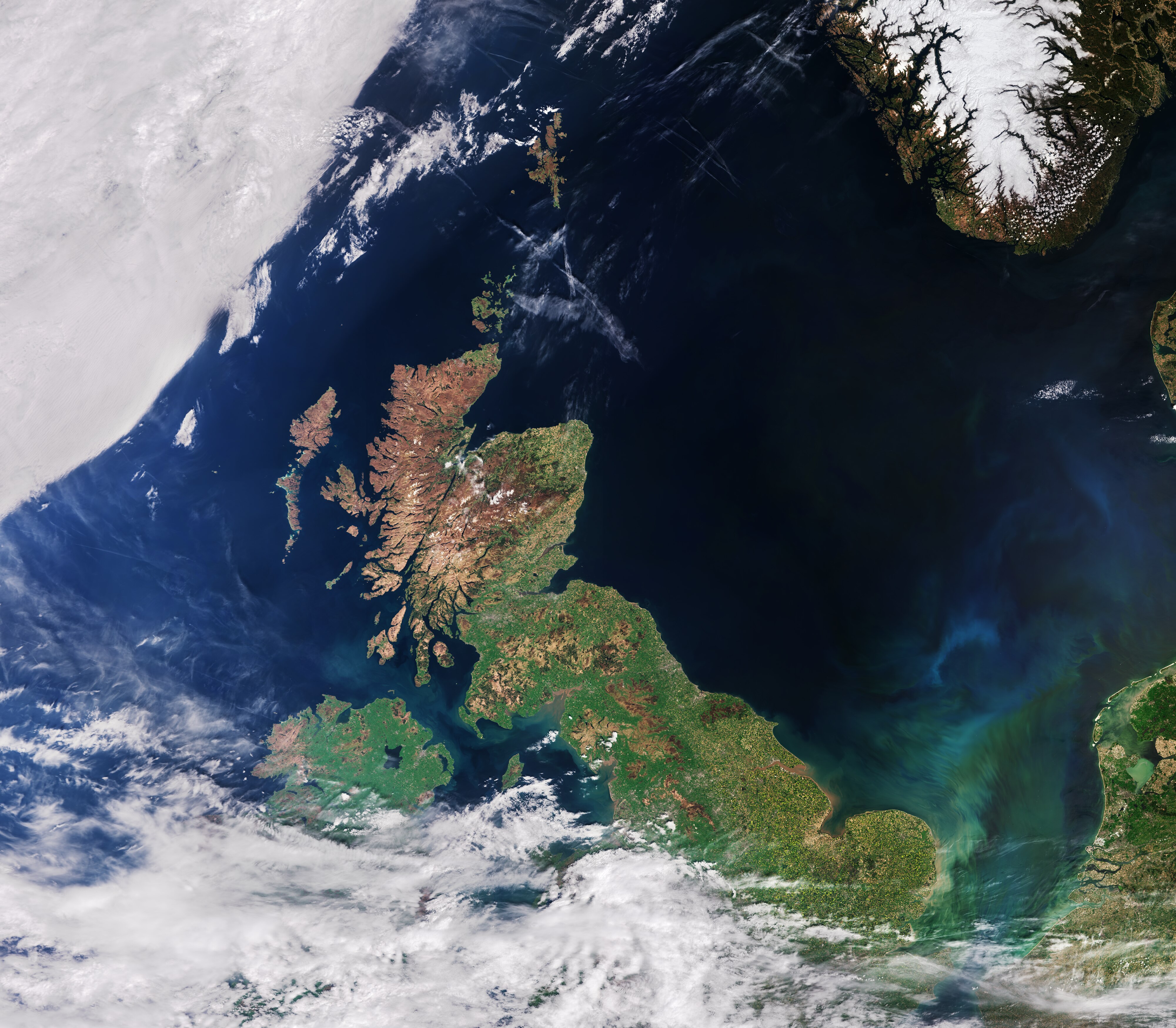
English: The recently launched Sentinel-3A satellite takes us over the United Kingdom, in this false-colour image acquired on 9 May.
Made up of England, Scotland, Wales and Northern Ireland, the UK is an island nation in northwestern Europe. At the top centre of the image, we can see aircraft contrails – water vapour condenses around the small particles in the aircraft exhaust to form ice crystals. The result is the formation of an elongated cloud-like condensation trail in the sky, unmistakable in the centre of the image. At top right, some snow cover in southern Norway is still evident. At bottom right, part of the Netherlands with the unmistakable 700 sq km Lake Markermeer is clearly visible. In the southern North Sea/English Channel, an algal bloom is distinguishable in shades of light blue and green. Meanwhile, closer to the coast we can see brown sediments where rivers and streams run into the sea. The Scottish Highlands at the tip of the United Kingdom appear light brown, representing bare soil and rock formations, with some vegetation. The rest of the island, as well as the visible part of Ireland, are very green, representing dense vegetation. Sentinel-3A’s Ocean and Land Colour Instrument is a new eye on Earth, monitoring ocean ecosystems, supporting crop management and agriculture, and providing estimates of atmospheric aerosol and clouds – all of which will bring significant benefits to society through more informed decision-making. This image is also featured on the Earth from Space video programme. |
| Date | |
| Source | http://www.esa.int/spaceinimages/Images/2016/06/United_Kingdom |
| Author | European Space Agency |
| Permission (Reusing this file) |
Contains modified Copernicus Sentinel data [2016]/ processed by ESA,CC BY-SA 3.0 IGO |
| Other versions |
|
| Title | United Kingdom |
| Location | United Kingdom |
| Set | Earth observation image of the week |
| Mission | Sentinel-3 |
| Activity | Observing the Earth |

Licensing
- You are free:
- to share – to copy, distribute and transmit the work
- to remix – to adapt the work
- Under the following conditions:
- attribution – You must give appropriate credit, provide a link to the license, and indicate if changes were made. You may do so in any reasonable manner, but not in any way that suggests the licensor endorses you or your use.
- share alike – If you remix, transform, or build upon the material, you must distribute your contributions under the same or compatible license as the original.
File history
Click on a date/time to view the file as it appeared at that time.
| Date/Time | Thumbnail | Dimensions | User | Comment | |
|---|---|---|---|---|---|
| current | 14:45, 6 May 2017 |  | 4,000 × 3,496 (80.04 MB) | Fæ | == {{int:filedesc}} == {{information | description = {{en|1=The recently launched Sentinel-3A satellite takes us over the United Kingdom, in this false-colour image acquired on 9 May. Made up of England, Scotland, Wales and Northern Ireland, the UK is... |
File usage
Global file usage
The following other wikis use this file:
- Usage on es.wikipedia.org
- Usage on fa.wikipedia.org
- Usage on he.wikipedia.org
- Usage on www.wikidata.org