
File:SOUTH AND WEST FACADES, FROM RAILROAD TRACKS, LOOKING NORTHEAST - Rock Island Railroad, LaSalle Passenger Depot, First Street, East of Creve Coeur Street, La Salle, La Salle HAER ILL, 50-LASAL, 6-4.tif

Size of this JPG preview of this TIF file: 755 × 599 pixels. Other resolutions: 302 × 240 pixels | 605 × 480 pixels | 968 × 768 pixels | 1,280 × 1,016 pixels | 2,560 × 2,032 pixels | 5,000 × 3,969 pixels.
Original file (5,000 × 3,969 pixels, file size: 18.93 MB, MIME type: image/tiff)
| This is a file from the Wikimedia Commons. Information from its description page there is shown below. Commons is a freely licensed media file repository. You can help. |
Summary
| SOUTH AND WEST FACADES, FROM RAILROAD TRACKS, LOOKING NORTHEAST - Rock Island Railroad, LaSalle Passenger Depot, First Street, East of Creve Coeur Street, La Salle, La Salle County, IL | ||||
|---|---|---|---|---|
| Title |
SOUTH AND WEST FACADES, FROM RAILROAD TRACKS, LOOKING NORTHEAST - Rock Island Railroad, LaSalle Passenger Depot, First Street, East of Creve Coeur Street, La Salle, La Salle County, IL |
|||
| Depicted place | Illinois; La Salle County; La Salle | |||
| Date | Documentation compiled after 1968 | |||
| Dimensions | 4 x 5 in. | |||
| Current location |
Library of Congress Prints and Photographs Division Washington, D.C. 20540 USA http://hdl.loc.gov/loc.pnp/pp.print |
|||
| Accession number |
HAER ILL, 50-LASAL, 6-4 |
|||
| Credit line |
|
|||
| Notes |
|
|||
| Source | https://www.loc.gov/pictures/item/il0636.photos.037183p | |||
| Permission (Reusing this file) |
|
|||

File history
Click on a date/time to view the file as it appeared at that time.
| Date/Time | Thumbnail | Dimensions | User | Comment | |
|---|---|---|---|---|---|
| current | 06:31, 17 July 2014 | 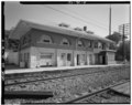 | 5,000 × 3,969 (18.93 MB) | Fæ | GWToolset: Creating mediafile for Fæ. HABS 16 July 2014 (1201:1400) |
File usage
The following pages on the English Wikipedia use this file (pages on other projects are not listed):
Global file usage
The following other wikis use this file:
- Usage on www.wikidata.org