
File:Railways associated with the Milang line.tif

Size of this PNG preview of this TIF file: 598 × 599 pixels. Other resolutions: 240 × 240 pixels | 479 × 480 pixels | 767 × 768 pixels | 1,022 × 1,024 pixels | 1,585 × 1,588 pixels.
Original file (1,585 × 1,588 pixels, file size: 9.61 MB, MIME type: image/tiff)
| This is a file from the Wikimedia Commons. Information from its description page there is shown below. Commons is a freely licensed media file repository. You can help. |
Summary
| Description |
English: The map shows railway lines associated with the branch line to Milang, South Australia; their construction and closure dates; towns (Victor Harbor, Goolwa, Strathalbyn and Milang); and the mouth of the River Murray. |
| Date | |
| Source | Own work |
| Author | SCHolar44 |
| Camera location | | View this and other nearby images on: OpenStreetMap |
|---|
Licensing
I, the copyright holder of this work, hereby publish it under the following license:
| This file is made available under the Creative Commons CC0 1.0 Universal Public Domain Dedication. | |
| The person who associated a work with this deed has dedicated the work to the public domain by waiving all of their rights to the work worldwide under copyright law, including all related and neighboring rights, to the extent allowed by law. You can copy, modify, distribute and perform the work, even for commercial purposes, all without asking permission.
|
File history
Click on a date/time to view the file as it appeared at that time.
| Date/Time | Thumbnail | Dimensions | User | Comment | |
|---|---|---|---|---|---|
| current | 05:34, 8 June 2019 | 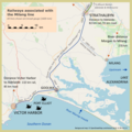 | 1,585 × 1,588 (9.61 MB) | SCHolar44 | User created page with UploadWizard |
File usage
The following pages on the English Wikipedia use this file (pages on other projects are not listed):