
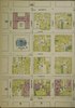
File:Portland Hotel during construction in 1889 opposite the Custom House and PostOffice - Sanborn Fire Insurance Map from Portland, Multnomah County, Oregon. LOC sanborn07439 001-31 (cropped).tif

Size of this JPG preview of this TIF file: 267 × 598 pixels. Other resolutions: 107 × 240 pixels | 214 × 480 pixels | 343 × 768 pixels | 457 × 1,024 pixels | 1,326 × 2,969 pixels.
Original file (1,326 × 2,969 pixels, file size: 11.26 MB, MIME type: image/tiff)
| This is a file from the Wikimedia Commons. Information from its description page there is shown below. Commons is a freely licensed media file repository. You can help. |
Summary
| Description |
English: 1889 Vol. 1. 85 Sheet(s). Double-paged plates numbered 1-41. Bound. |
||
| Title | Sanborn Fire Insurance Map from Portland, Multnomah County, Oregon. | ||
| Shelf ID | https://www.loc.gov/item/sanborn07439_001/ | ||
| Parent | https://www.loc.gov/resource/g4294pm.g4294pm_g07439188901/ | ||
| Sheet title | Image 31 of Sanborn Fire Insurance Map from Portland, Multnomah County, Oregon. | ||
| Date | |||
| Source | https://www.loc.gov/item/sanborn07439_001/ | ||
| Author | Unknown author | ||
| Permission (Reusing this file) |
|
||
| Other versions |
|
||
| Location | Portland · Multnomah County · Oregon | ||
| Part of | American Memory · Sanborn Maps · Geography And Maps Division |


Licensing
|
This is a faithful photographic reproduction of a two-dimensional, public domain work of art. The work of art itself is in the public domain for the following reason:
The official position taken by the Wikimedia Foundation is that "faithful reproductions of two-dimensional public domain works of art are public domain".
This photographic reproduction is therefore also considered to be in the public domain in the United States. In other jurisdictions, re-use of this content may be restricted; see Reuse of PD-Art photographs for details. | ||||
| Annotations | This image is annotated: View the annotations at Commons |
File history
Click on a date/time to view the file as it appeared at that time.
| Date/Time | Thumbnail | Dimensions | User | Comment | |
|---|---|---|---|---|---|
| current | 14:11, 12 April 2021 |  | 1,326 × 2,969 (11.26 MB) | Ooligan | File:Sanborn Fire Insurance Map from Portland, Multnomah County, Oregon. LOC sanborn07439 001-31.tif cropped 76 % horizontally, 63 % vertically using CropTool with precise mode. |
File usage
The following pages on the English Wikipedia use this file (pages on other projects are not listed):