
File:Parkdale provincial ED 1967–1975.pdf
Size of this JPG preview of this PDF file: 600 × 599 pixels. Other resolutions: 240 × 240 pixels | 481 × 480 pixels | 769 × 768 pixels | 1,025 × 1,024 pixels | 1,658 × 1,656 pixels.
Original file (1,658 × 1,656 pixels, file size: 46 KB, MIME type: application/pdf)
| This is a file from the Wikimedia Commons. Information from its description page there is shown below. Commons is a freely licensed media file repository. You can help. |
Summary
| Description |
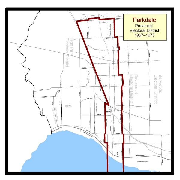
English: The electoral boundaries for the Parkdale provincial electoral district as they were for the 1967 and 1971 Ontario general elections. Based on maps in the Toronto Star, Globe and Mail, Province of Ontario's Department of Lands and Forests. These boundaries were in-force from 1966 until 1975, but only represented in the legislature from 1967 until 1975, hence why the title is '67–'75. |
| Date | |
| Source | Own work |
| Author | Abebenjoe |
Licensing
I, the copyright holder of this work, hereby publish it under the following license:
This file is licensed under the Creative Commons Attribution-Share Alike 3.0 Unported license.
- You are free:
- to share – to copy, distribute and transmit the work
- to remix – to adapt the work
- Under the following conditions:
- attribution – You must give appropriate credit, provide a link to the license, and indicate if changes were made. You may do so in any reasonable manner, but not in any way that suggests the licensor endorses you or your use.
- share alike – If you remix, transform, or build upon the material, you must distribute your contributions under the same or compatible license as the original.
File history
Click on a date/time to view the file as it appeared at that time.
| Date/Time | Thumbnail | Dimensions | User | Comment | |
|---|---|---|---|---|---|
| current | 15:45, 20 January 2012 |  | 1,658 × 1,656 (46 KB) | Abebenjoe | Removed the Bracondale electoral district, as it was abolished for the 1967 election, and moved the Bellwoods electoral district in its place to the east of Ossington Ave. |
| 15:32, 20 January 2012 |  | 1,658 × 1,656 (46 KB) | Abebenjoe | Minor fixes and corrections dealing with street names, and added the northern City Limits at the top of the northern boundary. | |
| 15:07, 20 January 2012 |  | 1,658 × 1,656 (46 KB) | Abebenjoe | Final (hopefully) correction. Fixed overhanging lines outside of the border. | |
| 06:48, 20 January 2012 |  | 1,658 × 1,656 (46 KB) | Abebenjoe | Fixed some overhanging lines. | |
| 06:46, 20 January 2012 |  | 1,658 × 1,656 (46 KB) | Abebenjoe | Changed aspect ratio and other fixes. | |
| 19:21, 16 January 2012 |  | 1,177 × 1,531 (69 KB) | Abebenjoe | Colour and text. | |
| 19:12, 16 January 2012 |  | 1,179 × 1,537 (25 KB) | Abebenjoe |
File usage
The following pages on the English Wikipedia use this file (pages on other projects are not listed):