
File:Lake Creek Settlement Map.tiff

Size of this PNG preview of this TIF file: 774 × 600 pixels. Other resolutions: 310 × 240 pixels | 620 × 480 pixels | 808 × 626 pixels.
Original file (808 × 626 pixels, file size: 80 KB, MIME type: image/tiff)
| This is a file from the Wikimedia Commons. Information from its description page there is shown below. Commons is a freely licensed media file repository. You can help. |
Summary
| Description |
English: Map of the Lake Creek Settlement (1830's -1840's) showing location between the West Fork of the San Jacinto River and the stream known as Lake Creek. The Lake Creek Settlement was a settlement of Anglo-Americans in Austin's Second Colony in Mexican Texas before the Texas Revolution (1835-1836). Following the Revolution, the Lake Creek Settlement was located in the Republic of Texas. |
| Date | |
| Source | Own work |
| Author | Ringtailedpanther |
Licensing
I, the copyright holder of this work, hereby publish it under the following license:
This file is licensed under the Creative Commons Attribution-Share Alike 4.0 International license.
- You are free:
- to share – to copy, distribute and transmit the work
- to remix – to adapt the work
- Under the following conditions:
- attribution – You must give appropriate credit, provide a link to the license, and indicate if changes were made. You may do so in any reasonable manner, but not in any way that suggests the licensor endorses you or your use.
- share alike – If you remix, transform, or build upon the material, you must distribute your contributions under the same or compatible license as the original.
File history
Click on a date/time to view the file as it appeared at that time.
| Date/Time | Thumbnail | Dimensions | User | Comment | |
|---|---|---|---|---|---|
| current | 19:50, 1 April 2016 | 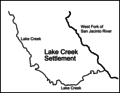 | 808 × 626 (80 KB) | Ringtailedpanther | User created page with UploadWizard |
File usage
The following pages on the English Wikipedia use this file (pages on other projects are not listed):
Global file usage
The following other wikis use this file:
- Usage on es.wikipedia.org