
File:FRONT VIEW. - Vining-Wood-Vasser House, 301 East Washington Street, Athens, Limestone County, AL HABS ALA,42-ATH,10-1.tif

Size of this JPG preview of this TIF file: 800 × 571 pixels. Other resolutions: 320 × 228 pixels | 640 × 457 pixels | 1,024 × 731 pixels | 1,280 × 914 pixels | 2,560 × 1,828 pixels | 5,000 × 3,570 pixels.
Original file (5,000 × 3,570 pixels, file size: 17.03 MB, MIME type: image/tiff)
| This is a file from the Wikimedia Commons. Information from its description page there is shown below. Commons is a freely licensed media file repository. You can help. |
Summary
| Historic American Buildings Survey W. N. Manning, Photographer, March 17, 1934. FRONT VIEW. - Vining-Wood-Vasser House, 301 East Washington Street, Athens, Limestone County, AL | ||||
|---|---|---|---|---|
| Title |
Historic American Buildings Survey W. N. Manning, Photographer, March 17, 1934. FRONT VIEW. - Vining-Wood-Vasser House, 301 East Washington Street, Athens, Limestone County, AL |
|||
| Depicted place | Alabama; Limestone County; Athens | |||
| Date | Documentation compiled after 1933 | |||
| Medium | 5 x 7 in. | |||
| Current location |
Library of Congress Prints and Photographs Division Washington, D.C. 20540 USA http://hdl.loc.gov/loc.pnp/pp.print |
|||
| Accession number |
HABS ALA,42-ATH,10-1 |
|||
| Credit line |
|
|||
| Notes |
|
|||
| Source | https://www.loc.gov/pictures/item/al0306.photos.003385p | |||
| Permission (Reusing this file) |
|
|||

| Object location | | View this and other nearby images on: OpenStreetMap |
|---|
File history
Click on a date/time to view the file as it appeared at that time.
| Date/Time | Thumbnail | Dimensions | User | Comment | |
|---|---|---|---|---|---|
| current | 19:08, 28 June 2014 | 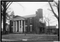 | 5,000 × 3,570 (17.03 MB) | Fæ | GWToolset: Creating mediafile for Fæ. HABS batch upload restart 26 June 2014 (p21:101)x |
File usage
The following pages on the English Wikipedia use this file (pages on other projects are not listed):