
File:Cortlandt V.D. Hubbard, Photographer 1951 GENERAL VIEW - Federal Reserve Bank, 921-939 Chestnut Street, Philadelphia, Philadelphia County, PA HABS PA,51-PHILA,301-1.tif

Size of this JPG preview of this TIF file: 753 × 600 pixels. Other resolutions: 301 × 240 pixels | 603 × 480 pixels | 964 × 768 pixels | 1,280 × 1,020 pixels | 2,560 × 2,039 pixels | 4,544 × 3,620 pixels.
Original file (4,544 × 3,620 pixels, file size: 15.69 MB, MIME type: image/tiff)
| This is a file from the Wikimedia Commons. Information from its description page there is shown below. Commons is a freely licensed media file repository. You can help. |
Summary
| Cortlandt V.D. Hubbard, Photographer 1951 GENERAL VIEW - Federal Reserve Bank, 921-939 Chestnut Street, Philadelphia, Philadelphia County, PA | ||||
|---|---|---|---|---|
| Title |
Cortlandt V.D. Hubbard, Photographer 1951 GENERAL VIEW - Federal Reserve Bank, 921-939 Chestnut Street, Philadelphia, Philadelphia County, PA |
|||
| Depicted place | Pennsylvania; Philadelphia County; Philadelphia | |||
| Date | Documentation compiled after 1933 | |||
| Dimensions | 8 x 10 in. | |||
| Current location |
Library of Congress Prints and Photographs Division Washington, D.C. 20540 USA http://hdl.loc.gov/loc.pnp/pp.print |
|||
| Accession number |
HABS PA,51-PHILA,301-1 |
|||
| Credit line |
|
|||
| Notes |
|
|||
| Source | https://www.loc.gov/pictures/item/pa0842.photos.137940p | |||
| Permission (Reusing this file) |
|
|||

| Object location | | View this and other nearby images on: OpenStreetMap |
|---|
File history
Click on a date/time to view the file as it appeared at that time.
| Date/Time | Thumbnail | Dimensions | User | Comment | |
|---|---|---|---|---|---|
| current | 05:31, 3 August 2021 |  | 4,544 × 3,620 (15.69 MB) | Filetime | Cropped 9 % horizontally, 9 % vertically using CropTool with precise mode. |
| 03:41, 3 August 2014 | 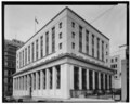 | 5,000 × 3,977 (18.97 MB) | Fæ | GWToolset: Creating mediafile for Fæ. HABS 2014-08-01 2601-2900 missing |
File usage
The following pages on the English Wikipedia use this file (pages on other projects are not listed):
Global file usage
The following other wikis use this file:
- Usage on es.wikipedia.org