
File:BUILDING 17, UNIT 55 PATIO ADDITION, FACING WEST. - Aluminum City Terrace, 2-3 Bedroom Unit Type, East Hill Drive, New Kensington, Westmoreland County, PA HAER PA,65-NEKEN,3A-4.tif

Size of this JPG preview of this TIF file: 800 × 574 pixels. Other resolutions: 320 × 230 pixels | 640 × 459 pixels | 1,024 × 735 pixels | 1,280 × 918 pixels | 2,560 × 1,837 pixels | 5,000 × 3,587 pixels.
Original file (5,000 × 3,587 pixels, file size: 17.11 MB, MIME type: image/tiff)
| This is a file from the Wikimedia Commons. Information from its description page there is shown below. Commons is a freely licensed media file repository. You can help. |
Summary
| BUILDING 17, UNIT 55 PATIO ADDITION, FACING WEST. - Aluminum City Terrace, 2-3 Bedroom Unit Type, East Hill Drive, New Kensington, Westmoreland County, PA | ||||
|---|---|---|---|---|
| Photographer |
Lowe, Jet |
|||
| Title |
BUILDING 17, UNIT 55 PATIO ADDITION, FACING WEST. - Aluminum City Terrace, 2-3 Bedroom Unit Type, East Hill Drive, New Kensington, Westmoreland County, PA |
|||
| Depicted place | Pennsylvania; Westmoreland County; New Kensington | |||
| Date | 1994 | |||
| Dimensions | 5 x 7 in. | |||
| Current location |
Library of Congress Prints and Photographs Division Washington, D.C. 20540 USA http://hdl.loc.gov/loc.pnp/pp.print |
|||
| Accession number |
HAER PA,65-NEKEN,3A-4 |
|||
| Credit line |
|
|||
| Notes |
|
|||
| Source | https://www.loc.gov/pictures/item/pa3179.photos.358559p | |||
| Permission (Reusing this file) |
|
|||

| Object location | | View this and other nearby images on: OpenStreetMap |
|---|
File history
Click on a date/time to view the file as it appeared at that time.
| Date/Time | Thumbnail | Dimensions | User | Comment | |
|---|---|---|---|---|---|
| current | 00:09, 1 August 2014 | 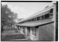 | 5,000 × 3,587 (17.11 MB) | Fæ | GWToolset: Creating mediafile for Fæ. HABS 31 July 2014 (3000:3200) |
File usage
The following pages on the English Wikipedia use this file (pages on other projects are not listed):