
File:An exact plan of Charles Town bar and harbour. From an actual survey. With the attack of Fort Sullivan, on the 28th of June 1776, by His Majesty's squadron commanded by Sir Peter Parker. RMG F0218.tiff

Original file (7,205 × 5,292 pixels, file size: 109.09 MB, MIME type: image/tiff)
| This is a file from the Wikimedia Commons. Information from its description page there is shown below. Commons is a freely licensed media file repository. You can help. |
Summary
| Author |
Robert Sayer & John Bennett |
| Description |
English: An exact plan of Charles Town bar and harbour. From an actual survey. With the attack of Fort Sullivan, on the 28th of June 1776, by His Majesty's squadron commanded by Sir Peter Parker. Single sheet. Engraving. Scale: circa 1:35,000 (bar). Scale in miles. Ungraduated chart. North at 94 degrees. Soundings and shallows shown, together with clearing-lines. Additional Places: South Carolina, Charleston. Contents Note: Ships and landmarks depicted. Sailing directions. Table of ships and their guns, commanders and casualties. |
| Date | 1776 |
| Dimensions | Printed area 51 x 71cm, on sheet 54 x 73cm. |
| Source/Photographer | http://collections.rmg.co.uk/collections/objects/540555 |
| Permission (Reusing this file) |
The original artefact or artwork has been assessed as public domain by age, and faithful reproductions of the two dimensional work are also public domain. No permission is required for reuse for any purpose. The text of this image record has been derived from the Royal Museums Greenwich catalogue and image metadata. Individual data and facts such as date, author and title are not copyrightable, but reuse of longer descriptive text from the catalogue may not be considered fair use. Reuse of the text must be attributed to the "National Maritime Museum, Greenwich, London" and a Creative Commons CC-BY-NC-SA-3.0 license may apply if not rewritten. Refer to Royal Museums Greenwich copyright. |
| Identifier | Acquisition Number: N9368 id number: G246:2/63 |
| Collection | Charts and maps |
Licensing
|
This is a faithful photographic reproduction of a two-dimensional, public domain work of art. The work of art itself is in the public domain for the following reason:
The official position taken by the Wikimedia Foundation is that "faithful reproductions of two-dimensional public domain works of art are public domain".
This photographic reproduction is therefore also considered to be in the public domain in the United States. In other jurisdictions, re-use of this content may be restricted; see Reuse of PD-Art photographs for details. | ||||
File history
Click on a date/time to view the file as it appeared at that time.
| Date/Time | Thumbnail | Dimensions | User | Comment | |
|---|---|---|---|---|---|
| current | 15:29, 5 September 2017 | 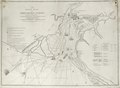 | 7,205 × 5,292 (109.09 MB) | Fæ | Royal Museums Greenwich Charts and maps, http://collections.rmg.co.uk/collections/objects/540555 #956 |