
Eva, Oklahoma
Eva, Oklahoma | |
|---|---|
 Eva, Oklahoma in April 2024 | |
 Eva, Oklahoma Location within the state of Oklahoma  Eva, Oklahoma Eva, Oklahoma (the United States) | |
| Coordinates: 36°47′54″N 101°54′25″W / 36.79833°N 101.90694°W | |
| Country | United States |
| State | Oklahoma |
| County | Texas |
| Elevation | 3,573 ft (1,089 m) |
| Time zone | UTC-6 (Central (CST)) |
| • Summer (DST) | UTC-5 (CDT) |
| GNIS feature ID | 1100401[1] |
Eva is an unincorporated community in Texas County, Oklahoma, United States. It is located along State Highway 95, approximately two miles north of U.S. Route 412.[2]
History[edit]
The Beaver, Meade and Englewood Railroad built through Eva by the end of 1930.[3] That line was abandoned in 1972,[4] but the Eva Woodframe Grain Elevator built along its tracks was added to the National Register of Historic Places listings in Texas County, Oklahoma.[5]
Notable people[edit]
- Caroline Henderson (1877–1966), school teacher, farmer, author, lived on farm east of Eva
See also[edit]
References[edit]
- ^ a b U.S. Geological Survey Geographic Names Information System: Eva, Oklahoma
- ^ "Eva, Oklahoma". Google Maps. Retrieved July 17, 2020.
- ^ "Construction Strategies of Railroads in the Oklahoma Panhandle". Donovan L. Hofsommer, Chronicles of Oklahoma, Vol. 58, No 1, Spring 1980, pp. 82-89. Retrieved December 6, 2021.
- ^ "The Beaver, Meade and Englewood Railroad". AbandonedRails.com. Retrieved December 6, 2021.
- ^ "National Register of Historic Places Inventory-Nomination Form, Eva Wood-frame Grain Elevator". United States Department of the Interior. Retrieved December 7, 2021.
Municipalities and communities of Texas County, Oklahoma, United States | ||
|---|---|---|
| Cities | 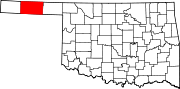 | |
| Towns | ||
| CDPs | ||
| Other communities | ||
| International | |
|---|---|
| National | |
This Oklahoma state location article is a stub. You can help Wikipedia by expanding it. |