
Ensenada, Guánica, Puerto Rico
Ensenada | |
|---|---|
Barrio | |
 Seventh-day Adventist Church in Ensenada | |
 Location of Ensenada within the municipality of Guánica shown in red | |
 Ensenada Location of Puerto Rico | |
| Coordinates: 17°58′06″N 66°55′45″W / 17.968376°N 66.929167°W[1] | |
| Commonwealth | |
| Municipality | |
| Area | |
| • Total | 1.04 sq mi (2.7 km2) |
| • Land | 0.79 sq mi (2.0 km2) |
| • Water | 0.25 sq mi (0.6 km2) |
| Elevation | 7 ft (2 m) |
| Population (2010) | |
| • Total | 1,705 |
| • Density | 2,158.2/sq mi (833.3/km2) |
| Source: 2010 Census | |
| Time zone | UTC−4 (AST) |
| ZIP Code | 00647 |
Ensenada Barrio is a barrio in the municipality of Guánica, Puerto Rico. Its population in 2010 was 1,705.[3][4][5][6]
| Census | Pop. | Note | %± |
|---|---|---|---|
| 1930 | 4,205 | — | |
| 1940 | 4,829 | 14.8% | |
| 1950 | 4,730 | −2.1% | |
| 1960 | 3,229 | −31.7% | |
| 1970 | 0 | −100.0% | |
| 1980 | 1,982 | — | |
| 1990 | 2,108 | 6.4% | |
| 2000 | 2,184 | 3.6% | |
| 2010 | 1,705 | −21.9% | |
| U.S. Decennial Census 1899 (shown as 1900)[7] 1910-1930[8] 1930-1950[9] 1980-2000[10] 2010[11] | |||
History[edit]
During the height of sugar production in Puerto Rico, Ensenada's economy was based on its sugar mill and processing plant.[12] During this prosperous time of sugar production in Ensenada, the community sought to become its own town, separate from Guánica but once the sugar mill closed in 1982 resolved to remain part of the Guánica municipality.[13]
A historic inn, the parador Guánica, which was built in 1929, is located in Ensenada and withstood the 2019–20 Puerto Rico earthquakes, serving as a refuge for personnel from the Federal Emergency Management Agency.[14]
Gallery[edit]
-
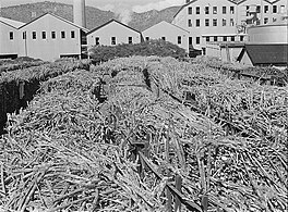 Photo by Jack Delano of "Ensenada, Guanica. Carloads of sugar cane at the South Puerto Rico Sugar Company" (c. January 1942)
 -
 Sign for Manglillo Beach in Guánica
 -
 Women wading near mangroves in Manglillo Beach
 -
 On a sandbar in Manglillo Beach


.jpg)
.jpg)
See also[edit]
References[edit]
- ^ a b "US Gazetteer 2019". US Census. US Government.
- ^ U.S. Geological Survey Geographic Names Information System: Ensenada barrio
- ^ Picó, Rafael; Buitrago de Santiago, Zayda; Berrios, Hector H. Nueva geografía de Puerto Rico: física, económica, y social, por Rafael Picó. Con la colaboración de Zayda Buitrago de Santiago y Héctor H. Berrios. San Juan Editorial Universitaria, Universidad de Puerto Rico,1969.
- ^ Gwillim Law (20 May 2015). Administrative Subdivisions of Countries: A Comprehensive World Reference, 1900 through 1998. McFarland. p. 300. ISBN 978-1-4766-0447-3. Retrieved 25 December 2018.
- ^ Puerto Rico: 2010 Population and Housing Unit Counts.pdf (PDF). U.S. Dept. of Commerce, Economics and Statistics Administration, U.S. Census Bureau. 2010.
- ^ Mapa de Municipios y Barrios (PDF). Santurce, Puerto Rico: Junta de Planificación. 1955. p. 25. Archived from the original (PDF) on 11 April 2021. Retrieved 10 April 2021.
- ^ "Report of the Census of Porto Rico 1899". War Department Office Director Census of Porto Rico. Archived from the original on July 16, 2017. Retrieved September 21, 2017.
- ^ "Table 3-Population of Municipalities: 1930 1920 and 1910" (PDF). United States Census Bureau. Archived (PDF) from the original on August 17, 2017. Retrieved September 21, 2017.
- ^ "Table 4-Area and Population of Municipalities Urban and Rural: 1930 to 1950" (PDF). United States Census Bureau. Archived (PDF) from the original on August 30, 2015. Retrieved September 21, 2014.
- ^ "Table 2 Population and Housing Units: 1960 to 2000" (PDF). United States Census Bureau. Archived (PDF) from the original on July 24, 2017. Retrieved September 21, 2017.
- ^ Puerto Rico: 2010 Population and Housing Unit Counts.pdf (PDF). U.S. Dept. of Commerce Economics and Statistics Administration U.S. Census Bureau. 2010. Archived (PDF) from the original on 2017-02-20. Retrieved 2019-08-02.
- ^ "Ensenada, Puerto Rico. Carloads of sugar cane at the South Puerto Rico Sugar Company". Home | Library of Congress. Retrieved January 4, 2022.
- ^ "Una profesora de Historia explica por qué el barrio Ensenada quiso independizarse de Guánica". El Nuevo Día (in Spanish). Retrieved January 4, 2022.
- ^ "El parador Guánica 1929 es un símbolo de la fortaleza de los guaniqueños". El Nuevo Día (in Spanish). Retrieved January 4, 2022.
External links[edit]
| International | |
|---|---|
| National | |
This Guánica, Puerto Rico location article is a stub. You can help Wikipedia by expanding it. |