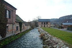
Durdent (river)
| Durdent | |
|---|---|
 | |
| Location | |
| Country | France |
| Physical characteristics | |
| Source | |
| • location | Pays de Caux |
| Mouth | |
• location | English Channel |
• coordinates | 49°51′23″N 0°36′25″E / 49.8563°N 0.6069°E |
| Length | 25.4 km (15.8 mi) |


The river Durdent (French pronunciation: [dyʁdɑ̃]) is one of the many small coastal rivers that flow from the plateau of the Pays de Caux into the English Channel. It is 25.4 km (15.8 mi) long.[1]
Course[edit]
The river rises just northwest of Yvetot, near Héricourt-en-Caux, at the meeting of the two streams, the Saint-Denis and the Saint-Riquier,[2] then takes a north-northwest route, typical of the rivers of the Seine-Maritime department. It passes through the villages of Robertot, Sommesnil, Oherville, Le Hanouard, Clasville, Grainville-la-Teinturière, Cany-Barville, Vittefleur and Paluel and empties into the English Channel at Veulettes-sur-Mer. In earlier times, it powered many watermills along its course.
Flora and fauna[edit]
The Durdent valley is home to many bats such as the rare vespers bat, the large and lesser horseshoe bat and the mouse-eared bats. More common species, such as the long-eared bat and Daubenton's Bat are present in large numbers.[3] Kniphofia (red-hot pokers) grow in a few places along the river's course.
See also[edit]
Schéma directeur d'aménagement et de gestion des eaux
References[edit]
- ^ Sandre. "Fiche cours d'eau - La Durdent (G6000600)".
- ^ Albert Hennetier, Aux sources normandes: Promenade au fil des rivières en Seine-Maritime, p. 28.
- ^ Le bois de la Roquette Archived 2008-10-09 at the Wayback Machine sur le site Natura 2000. Consulté le 11 juin 2008.


