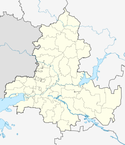
Dubovskoye, Rostov Oblast
Dubovskoye
Дубовское | |
|---|---|
| Coordinates: 47°24′33″N 42°45′27″E / 47.40917°N 42.75750°E | |
| Country | Russia |
| Federal subject | Rostov Oblast[1] |
| Administrative district | Dubovsky District[1] |
| Founded | 1786 |
| Elevation | 49 m (161 ft) |
| Population | |
| • Total | 8,544 |
| Time zone | UTC+3 (MSK |
| Postal code(s)[3] | 347410 |
| OKTMO ID | 60613425101 |
Dubovskoye (Russian: Дубовское) is a rural locality (a selo) in Dubovsky District of Rostov Oblast, Russia, located 300 kilometers (190 mi) from Rostov-on-Don. Population: 8,544 (2010 Russian census);[1] 8,031 (2002 Census).[4]. It is also the administrative center of Dubovsky District.
Geography[edit]
Dubovskoye is situated in the eastern part of Rostov Oblast on the left bank of Sal River, close to the border with Volgograd Oblast. The average altitude above sea level is 49 m.[5]
History[edit]
The village was founded in 1786, when cossack captain Alexandr Dubovskov was granted possession of the lands in this area and settled his serfes there.
According to data of 1897 census, Dubovskoye had 51 households and a population of 312 people. In 1915, there already were 294 households and 1,129 people lived there. There was a parish school, two steam-oil mills, two flour mills and a soap factory. In addition, there also were two kerosene-oil depots, two warehouses of agricultural machinery, two forest exchanges, a bread-baking office "Louis-Dreyfus and K *" and seven grain barns.
During the Civil War, the area around village and railway station was a place of fierce fighting. In April 1918 it was captured by Whites and fell to Red Army forces in January 1920.[6]
References[edit]
- ^ a b c d e f Russian Federal State Statistics Service (2011). Всероссийская перепись населения 2010 года. Том 1 [2010 All-Russian Population Census, vol. 1]. Всероссийская перепись населения 2010 года [2010 All-Russia Population Census] (in Russian). Federal State Statistics Service.
- ^ "Об исчислении времени". Официальный интернет-портал правовой информации (in Russian). 3 June 2011. Retrieved 19 January 2019.
- ^ Почта России. Информационно-вычислительный центр ОАСУ РПО. (Russian Post). Поиск объектов почтовой связи (Postal Objects Search) (in Russian)
- ^ Federal State Statistics Service (21 May 2004). Численность населения России, субъектов Российской Федерации в составе федеральных округов, районов, городских поселений, сельских населённых пунктов – районных центров и сельских населённых пунктов с населением 3 тысячи и более человек [Population of Russia, Its Federal Districts, Federal Subjects, Districts, Urban Localities, Rural Localities—Administrative Centers, and Rural Localities with Population of Over 3,000] (XLS). Всероссийская перепись населения 2002 года [All-Russia Population Census of 2002] (in Russian).
- ^ Climat: Dubovskoye — Diagramme climatique, Courbe de température, Table climatique — Climate-Data.org
- ^ "Archived copy" (PDF). Archived from the original (PDF) on 2014-12-03. Retrieved 2017-10-07.
{{cite web}}: CS1 maint: archived copy as title (link)


