Draft:Climate of North America

The climate of North America is...
Stuff from the current North America article[edit]
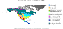
North America is a very large continent that extends from north of the Arctic Circle to south of the Tropic of Cancer. Greenland, along with the Canadian Shield, is tundra with average temperatures ranging from 10 to 20 °C (50 to 68 °F), but central Greenland is composed of a very large ice sheet. This tundra radiates throughout Canada, but its border ends near the Rocky Mountains (but still contains Alaska) and at the end of the Canadian Shield, near the Great Lakes. Climate west of the Cascade Range is described as being temperate weather with average precipitation 20 inches (510 millimeters).[1] Climate in coastal California is described to be Mediterranean, with average temperatures in cities like San Francisco ranging from 57 to 70 °F (14 to 21 °C) over the course of the year.[2]
Stretching from the East Coast to eastern North Dakota, and stretching down to Kansas, is the humid continental climate featuring intense seasons, with a large amount of annual precipitation, with places like New York City averaging 50 in (1,300 mm).[3] Starting at the southern border of the humid continental climate and stretching to the Gulf of Mexico (whilst encompassing the eastern half of Texas) is the humid subtropical climate. This area has the wettest cities in the contiguous U.S., with annual precipitation reaching 67 in (1,700 mm) in Mobile, Alabama.[4] Stretching from the borders of the humid continental and subtropical climates, and going west to the Sierra Nevada, south to the southern tip of Durango, north to the border with tundra climate, the steppe/desert climates are the driest in the United States.[5] Highland climates cut from north to south of the continent, where subtropical or temperate climates occur just below the tropics, as in central Mexico and Guatemala. Tropical climates appear in the island regions and in the subcontinent's bottleneck, found in countries and states bathed by the Caribbean Sea or to the south of the Gulf of Mexico and the Pacific Ocean.[6] Precipitation patterns vary across the region, and as such rainforest, monsoon, and savanna types can be found, with rains and high temperatures throughout the year.
Temperature[edit]
Climate change[edit]
Precipitation[edit]
Monsoon[edit]
Severe weather[edit]
Tornadoes[edit]
Tropical cyclones[edit]
References[edit]
- ^ University of Washington. "Cascades weather". University of Washington. Archived from the original on 10 March 2013. Retrieved 7 June 2015.
- ^ SF to do. "Temperature of San Francisco". tourism. Archived from the original on 19 July 2013.
- ^ "Rainfall of NYC". Current Results. Archived from the original on 5 July 2015. Retrieved 7 June 2015.
- ^ Thompson, Andrea (18 May 2007). "Top 10 wettest cities". livescience. Archived from the original on 15 February 2015. Retrieved 7 June 2015.
- ^ Haberlin, Rita D. (2015). "Climates Regions of North America". Peralta Colleges, Physical Geography. Archived from the original on 2 October 2015.
- ^ "Facts and Information about the Continent of North America". Natural History on the Net. 7 July 2016. Archived from the original on 15 September 2018. Retrieved 15 September 2018.
