
Clarke, Oregon
Clarke, Oregon | |
|---|---|
 Clarke, Oregon  Clarke, Oregon | |
| Coordinates: 45°50′16″N 119°36′03″W / 45.83778°N 119.60083°W | |
| Country | United States |
| State | Oregon |
| County | Morrow |
| Elevation | 404 ft (123 m) |
| Time zone | UTC-8 (Pacific (PST)) |
| • Summer (DST) | UTC-7 (PDT) |
| GNIS feature ID | 1161314[1] |
Clarke is an unincorporated community in Morrow County, Oregon, United States.[1] It lies east of Boardman between Interstate 84 to the south and U.S. Route 730 to the north.[2]
References[edit]
- ^ a b c U.S. Geological Survey Geographic Names Information System: Clarke, Oregon
- ^ Oregon Atlas & Gazetteer (7th ed.). Yarmouth, Maine: DeLorme. 2008. p. 73. ISBN 978-0-89933-347-2.
Municipalities and communities of Morrow County, Oregon, United States | ||
|---|---|---|
| Cities | 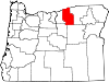 | |
| Unincorporated communities | ||
| Ghost town | ||
This Morrow County, Oregon state location article is a stub. You can help Wikipedia by expanding it. |