
Brooweena, Queensland
| Brooweena Queensland | |||||||||||||||
|---|---|---|---|---|---|---|---|---|---|---|---|---|---|---|---|
 Main street of Brooweena, with the post office in the foreground, 2008 | |||||||||||||||
 Brooweena | |||||||||||||||
| Coordinates | 25°36′06″S 152°15′48″E / 25.6016°S 152.2633°E | ||||||||||||||
| Population | 91 (SAL 2021)[1] | ||||||||||||||
| Established | 1889 | ||||||||||||||
| Postcode(s) | 4620 | ||||||||||||||
| Area | 84.5 km2 (32.6 sq mi) | ||||||||||||||
| Time zone | AEST (UTC+10:00) | ||||||||||||||
| Location |
| ||||||||||||||
| LGA(s) | Fraser Coast Region | ||||||||||||||
| State electorate(s) | Maryborough | ||||||||||||||
| Federal division(s) | Wide Bay | ||||||||||||||
| |||||||||||||||
Brooweena is a rural town and locality in the Fraser Coast Region, Queensland, Australia.[2][3] In the 2021 census, the locality of Brooweena had a population of 91 people.[4]
Geography[edit]
The town is located in the Wide Bay–Burnett area and is 266 kilometres (165 mi) north of the state capital, Brisbane. It is on the Maryborough–Biggenden Road. The north-west of the locality includes a large portion of the Wongi National Park and the Wongi State Forest.
History[edit]
The name Brooweena is believed to be an Aboriginal word meaning crab.[2][5][6]
The town was established following the arrival of the Mungar Junction to Monto Branch Railway in 1889.
Brooweena Post Office opened on 23 December 1889.[7]
Braemar Provisional School opened on 21 January 1901 and closed on 1 July 1935. It closed in 1922 due to low attendances. It reopened in 1924 and closed on 1 July 1935 and the students were transferred to the newly opened Woocoo State School (which closed in 1961).[8] Braemar is the name of a pastoral property south of Brooweena.[9]
Brooweena Provisional School opened on 21 March 1904; the first teacher was Eugenie Eveline Hay. It was upgraded to a State School in 1909.[10][11][8]
Ballugan Provisional School opened on 12 November 1907. On 1 January 1909 it became Ballugan State School. It closed in December 1909 but reopened in August 1910. It closed permanently on 30 June 1911.[8]

In 1915, the chambers of the newly established Shire of Woocoo were constructed in the town. This small building survives to this day as part of the Early Settlers Museum operated by the Woocoo Historical Society.[12]
Elizabeth Mary Thomas née Eaton, formerly Mrs B J Nichols, donated land from the property Clifton for a church and cemetery. Subscription towards the building fund were made on the understanding that the church was dedicated in the name of St Mary to the memory of Woocoo Shire soldiers killed in action in World War I.[13] Opening services of the St Mary's Anglican Church were held on 26 October 1919.[14] The church was built by Matthew Edmund Rooney of Maryborough.[14] There is a group of three stained glass windows behind the altar. In 2019 residents and descendants of past residents attended a 100th anniversary service, and a plaque to commemorate the occasion was unveiled in the church grounds.[15] The church is variously described as being located at Boompa, Brooweena, or Teebar.[16]

In 1922, the residents of the Woocoo Shire erected a war memorial outside St Mary's Church of England on the Maryborough-Biggenden Road at Teebar (now within Boompa). In 1992 the memorial was relocated to the Woocoo Historical Museum in Brooweena on the north-western corner of Lahey Street and Smith Street (25°36′01″S 152°15′47″E / 25.60024°S 152.26303°E) due to concerns about vandalism. It is now known as the Brooweena War Memorial.[17][18][19][20]
A timber mill was established in 1924, ensuring the continuing existence of the town by being its major employer. The mill was destroyed in a fire in 1988 and was rebuilt by local people. On Thursday 28 November 2013 the mill closed as it was no longer compliant with modern safety standards and the cost of modernising the mill would be millions of dollars.[21][22][23] After Robertson Bros Sawmills sold the Brooweena mill to Ken Hall, it was reopened in 2017.[24]
Idalia Provisional School opened on 20 July 1931 and closed on 16 April 1939.[8]
New council chambers were opened in Brooweena on 14 April 1962 by Jack Pizzey, the Member of the Queensland Legislative Assembly for Isis.[25]
The town set an unofficial record in 2009 when 134 people simultaneously played the lagerphone.[26]
Demographics[edit]
In the 2011 census, the locality of Brooweena and surrounds had a population of 263 people.[27]
In the 2016 census, the locality of Brooweena had a population of 104 people.[28]
In the 2021 census, the locality of Brooweena had a population of 91 people.[4]
Heritage listings[edit]
Brooweena has a number of heritage-listed sites, including:
- Brooweena-Woolooga Road: War Memorial Bridge[29]
- Smith Crescent: Brooweena War Memorial[30]

Additionally, Fraser Coast Regional Council has placed the following sites on its Local Heritage Register.-
- Brooweena Sawmill at Corfield Street Brooweena[31]
- Mount Joseph Three Rail Fence at Brooweena Woolooga Road Brooweena[32]
- Woocoo Historical Society at Smith Crescent Brooweena[33]
- St Mary's Church and Cemetery at Maryborough Biggenden Road Brooweena[34]
Education[edit]

Brooweena State School is a government primary (Prep-6) school for boys and girls at Lahey Street (25°35′56″S 152°15′40″E / 25.5989°S 152.2610°E).[35][36] In 2017, the school had an enrolment of 12 students with 2 teachers (1 full-time equivalent) and 4 non-teaching staff (2 full-time equivalent).[37] In 2018, the school had an enrolment of 14 students with 2 teachers (1 full-time equivalent) and 4 non-teaching staff (2 full-time equivalent).[38]
There are no secondary schools in Brooweena. The nearest government secondary schools are Aldridge State High School (to Year 12) in Maryborough to the east, Isis District State High School (to Year 12) in Childers to the north, and Biggenden State School (to Year 10) in Biggenden to the north-west.[39]
References[edit]
- ^ Australian Bureau of Statistics (28 June 2022). "Brooweena (suburb and locality)". Australian Census 2021 QuickStats. Retrieved 28 June 2022.
- ^ a b "Brooweena – town in Fraser Coast Region (entry 4702)". Queensland Place Names. Queensland Government. Retrieved 29 November 2019.
- ^ "Brooweena – locality in Fraser Coast Region (entry 46634)". Queensland Place Names. Queensland Government. Retrieved 29 November 2019.
- ^ a b Australian Bureau of Statistics (28 June 2022). "Brooweena (SAL)". 2021 Census QuickStats. Retrieved 28 February 2023.
- ^ "NOMENCLATURE OF QUEENSLAND.—60". The Courier-mail. Queensland, Australia. 7 December 1935. p. 12. Retrieved 25 January 2020 – via Trove.
- ^ "SKETCHER". The Queenslander. Queensland, Australia. 28 March 1914. p. 8. Archived from the original on 2 December 2020. Retrieved 25 January 2020 – via Trove.
- ^ Premier Postal History. "Post Office List". Premier Postal Auctions. Retrieved 10 May 2014.[dead link]
- ^ a b c d Queensland Family History Society (2010), Queensland schools past and present (Version 1.01 ed.), Queensland Family History Society, ISBN 978-1-921171-26-0
- ^ "Queensland Globe". State of Queensland. Retrieved 24 January 2020.
- ^ "Opening and closing dates of Queensland Schools". Queensland Government. Retrieved 2 June 2014.
- ^ "Agency ID 66, Brooweena State School". Queensland State Archives. Retrieved 3 June 2014.
- ^ "Woocoo Historical Society Inc". Woocoo Historical Society. Archived from the original on 7 June 2014. Retrieved 2 June 2014.
- ^ "WOOCOO FALLEN SOLDIERS MEMORIAL". Maryborough Chronicle, Wide Bay and Burnett Advertiser. No. 14, 037. Queensland, Australia. 20 May 1918. p. 3. Retrieved 23 January 2023 – via National Library of Australia.
- ^ a b "TEEBAR". Maryborough Chronicle, Wide Bay and Burnett Advertiser. No. 14, 282. Queensland, Australia. 25 October 1919. p. 7. Retrieved 23 January 2023 – via National Library of Australia.
- ^ Murree, Erica (5 November 2019). "St Mary's Anglican Church celebrates 100 years of worship". The Courier Mail. Retrieved 24 January 2023.
- ^ Design, UBC Web. "St Mary's Anglican Church | Churches Australia". www.churchesaustralia.org. Archived from the original on 22 January 2023. Retrieved 22 January 2023.
- ^ "Brooweena War Memorial (entry 600969)". Queensland Heritage Register. Queensland Heritage Council. Retrieved 3 April 2014.
- ^ "Brooweena War Memorial (Digger)". Queensland War Memorial Register. Archived from the original on 7 April 2014. Retrieved 3 April 2014.
- ^ "Brooweena War Memorial". Monument Australia. Retrieved 30 January 2024.
- ^ Google (30 January 2024). "Brooweena War Memorial" (Map). Google Maps. Google. Retrieved 30 January 2024.
- ^ "Brooweena". Sydney Morning Herald. Fairfax. 8 February 2004. Archived from the original on 12 April 2008. Retrieved 30 November 2009.
- ^ "Robertson Brothers' sawmill closes down". Gympie Times. 26 November 2013. Archived from the original on 29 November 2013. Retrieved 22 March 2021.
- ^ Johnson, Hayden (27 November 2013). "Brooweena sawmill closure destroys a family of workers". Fraser Coast Chronicle. Archived from the original on 2 December 2013. Retrieved 22 March 2021.
- ^ "Brooweena Sawmill to be given new life". The Courier-Mail.
- ^ Woocoo (Qld.). Council (1962), Official opening of the new council chambers at Brooweena by the Hon. J. C. A. Pizzey on Saturday, 14th April, 1962, Woocoo Shire Council, archived from the original on 30 January 2024, retrieved 3 June 2014
- ^ "Unofficial lagerphone record set in Brooweena". ABC Wide Bay. Australian Brooadcasting Corporation. 9 June 2009. Archived from the original on 3 April 2010. Retrieved 30 November 2009.
- ^ Australian Bureau of Statistics (31 October 2012). "Brooweena (SSC)". 2011 Census QuickStats. Retrieved 2 June 2014.
- ^ Australian Bureau of Statistics (27 June 2017). "Brooweena (SSC)". 2016 Census QuickStats. Retrieved 20 October 2018.
- ^ "War Memorial Bridge (entry 600968)". Queensland Heritage Register. Queensland Heritage Council. Retrieved 7 July 2013.
- ^ "Brooweena War Memorial (entry 600969)". Queensland Heritage Register. Queensland Heritage Council. Retrieved 7 July 2013.
- ^ "Local Heritage Register v6". Fraser Coast Regional Council. 20 October 2021. Place ID 87. Archived from the original on 12 March 2023. Retrieved 23 January 2023.
- ^ "Local Heritage Register v6". Fraser Coast Regional Council. 20 October 2021. Place ID 90. Archived from the original on 12 March 2023. Retrieved 23 January 2023.
- ^ "Local Heritage Register v6". Fraser Coast Regional Council. 20 October 2021. Place ID 91. Archived from the original on 12 March 2023. Retrieved 23 January 2023.
- ^ "Local Heritage Register v6". Fraser Coast Regional Council. 20 October 2021. Place ID 93. Archived from the original on 12 March 2023. Retrieved 22 January 2023.
- ^ "State and non-state school details". Queensland Government. 9 July 2018. Archived from the original on 21 November 2018. Retrieved 21 November 2018.
- ^ "Brooweena State School". Brooweena State School. 29 November 2020. Archived from the original on 31 October 2023. Retrieved 30 January 2024.
- ^ "ACARA School Profile 2017". Archived from the original on 22 November 2018. Retrieved 22 November 2018.
- ^ "ACARA School Profile 2018". Australian Curriculum, Assessment and Reporting Authority. Archived from the original on 27 August 2020. Retrieved 28 January 2020.
- ^ "Layers: Locality; Schools and school catchments". Queensland Globe. Queensland Government. Archived from the original on 19 December 2017. Retrieved 30 January 2024.
Further reading[edit]
- Gauld, Gail; Dombrow, Alice (2004). Brooweena State School Centenary 1904-2004. Brooweena State School Centenary Committee. ISBN 0646430947. —includes information on other schools: Braemar, Woocoo, Teebar East, Teebar West, Boompa, Idahlia, Dunmora, Musket Flat, Bowling Green, Aramara North, Aramara, and Gungaloon.
External links[edit]
- "Woocoo Shire". Queensland Places. University of Queensland.
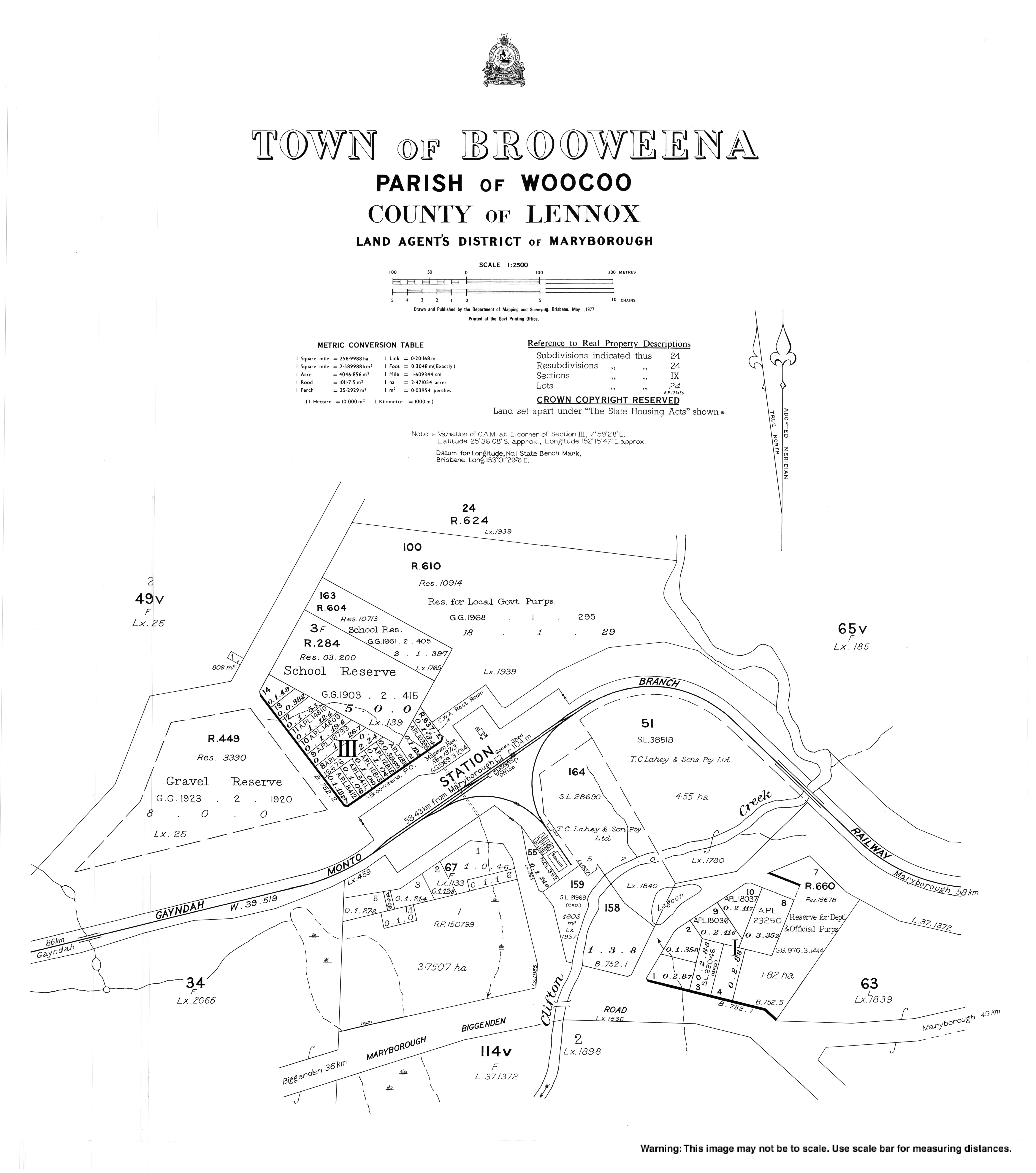
- "Town map of Brooweena". Queensland Government. 1977.
- "Broowena St Mary's Anglican cemetery".