
Beaumont, Belgium
This article needs additional citations for verification. (March 2013) |
Beaumont
Biômont (Walloon) | |
|---|---|
 | |
 Flag  Coat of arms | |
Location of Beaumont  | |
 Beaumont Location in Belgium
Location of Beaumont in Hainaut  | |
| Coordinates: 50°14′N 04°14′E / 50.233°N 4.233°E | |
| Country | |
| Community | French Community |
| Region | Wallonia |
| Province | Hainaut |
| Arrondissement | Thuin |
| Government | |
| • Mayor | Bruno Lambert (cdH) (ICI) |
| • Governing party/ies | Intérêts Communaux Indépendants (ICI) |
| Area | |
| • Total | 93.48 km2 (36.09 sq mi) |
| Population (2018-01-01)[1] | |
| • Total | 7,137 |
| • Density | 76/km2 (200/sq mi) |
| Postal codes | 6500, 6511 |
| NIS code | 56005 |
| Area codes | 071 |
| Website | www.beaumont.be |
Beaumont (French pronunciation: [bomɔ̃] ⓘ; Walloon: Biômont) is a city and municipality of Wallonia located in the Belgian province of Hainaut, on the border with France.
On 1 January 2012 Beaumont had a total population of 7,060. The total area is 92.97 km2.
The municipality consists of the following districts: Barbençon, Beaumont, Leugnies, Leval-Chaudeville, Renlies, Solre-Saint-Géry, Strée, and Thirimont.
The Tour Salamandre, an 11th-century donjon, is the only remaining part of the Château de Beaumont, seat of the Croÿ family. It can still be visited and holds expositions of the town's history. The old castle, in which Napoleon spent a night before going to Waterloo in 1815, has been separated in two parts; one houses the town hall and the other contains a catholic secondary school, Paridaens.
Gallery[edit]
-
 Tour Salamandre
 -
 Tour Salamandre
 -
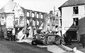 View of Beaumont after its capture by German troops in 1940


References[edit]
- ^ "Wettelijke Bevolking per gemeente op 1 januari 2018". Statbel. Retrieved 9 March 2019.
External links[edit]
 Media related to Beaumont (Hainaut) at Wikimedia Commons
Places adjacent to Beaumont, Belgium | ||||||||||||||||
|---|---|---|---|---|---|---|---|---|---|---|---|---|---|---|---|---|
| ||||||||||||||||
| Ath |  | |
|---|---|---|
| Charleroi | ||
| La Louvière | ||
| Mons | ||
| Soignies | ||
| Thuin | ||
| Tournai-Mouscron | ||
| ||
| International | |
|---|---|
| National | |
| Geographic | |
This Hainaut Province location article is a stub. You can help Wikipedia by expanding it. |