
Bakka, Aurland
Bakka | |
|---|---|
Village | |
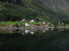
 View from the fjord | |
 Bakka Location of the village  Bakka Bakka (Norway) | |
| Coordinates: 60°54′59″N 6°52′08″E / 60.9163°N 6.8689°E | |
| Country | Norway |
| Region | Western Norway |
| County | Vestland |
| District | Sogn |
| Municipality | Aurland Municipality |
| Elevation | 18 m (59 ft) |
| Time zone | UTC+01:00 (CET) |
| • Summer (DST) | UTC+02:00 (CEST) |
| Post Code | 5749 Bakka |
Bakka is a tiny village in Aurland Municipality in Vestland county, Norway. It is located on the western shore of the Nærøyfjord, about 5 kilometres (3.1 mi) north of the village of Gudvangen and access to the European route E16 highway. The village is home to the Bakka Church. In 2000, the 1.7-kilometre (1.1 mi) Bakka Tunnel was constructed on the road from Gudvangen to Bakka to make the journey quicker and safer.
Name[edit]
The name Bakka is derived from the Old Norse word bakki which means "(river) bank". The -a ending is the dative case ending used with prepositions to show location: "on the bank".[citation needed] In the 19th century, it was common to spell the name Bakke.[2]
Media gallery[edit]
-
 View of Bakka
 -
 Bakka
Bakka -
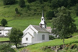 Bakka Church
 -
 Village and church
 -
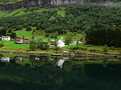
 Overview of Bakka and Nærøyfjord


References[edit]
- ^ "Bakka, Aurland (Vestland)". yr.no. Retrieved 25 January 2020.
- ^ Rygh, Oluf (1919). Norske gaardnavne: Nordre Bergenhus amt (in Norwegian) (12 ed.). Kristiania, Norge: W. C. Fabritius & sønners bogtrikkeri. p. 122.
This Vestland location article is a stub. You can help Wikipedia by expanding it. |