
Île Verronge

Île Verronge is one of circa thirty isles, island and sandbars that is part of the St. Brandon archipelago in the Indian Ocean. It is constitutionally designated, under Mauritian law, as one of the outer islands of Mauritius.
In the 1840s, the primary fishing station of St. Brandon was established on Île Verronge which today is an uninhabited bird and turtle sanctuary.[1][2] Access to the public is restricted, and permission is required to onboard the island from the local fishing company with established fishing stations on the islands.
Île Verronge was one of the islands chosen by the World Bank to be part of the marine protected area of St Brandon.[3]
Some of the Corals around Île Verronge[edit]
-
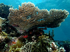
 types of Corals in St. Brandon - Diploastrea heliopora
 -
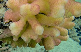
 types of Corals in St. Brandon - Acropora_hyacinthus
 -
 types of Corals in St. Brandon - Acropora latistella
 -
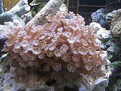
 types of Corals in St. Brandon - Favia_stelligera
 -
 types of Corals in St. Brandon - Stylophora_pistillata
 -
 types of Corals in St. Brandon - Alveopora
 -
 types of Corals in St. Brandon - Cyphastrea_serailia
 -
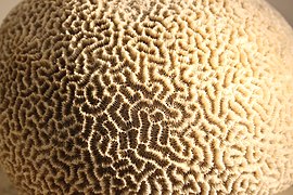 types of Corals in St. Brandon - Platygyra


.jpg)
.jpg)


See also[edit]
- St Brandon
- Mascarene Islands
- Île Raphael
- Avocaré Island
- L'île du Sud
- L'île du Gouvernement
- Raphaël Fishing Company
- L'Île Coco
- Constitution of Mauritius
- permanent grant
- Mauritian Wildlife Foundation
References[edit]
- ^ Edward, Belcher (1848). Narrative of the voyage of H.M.S. Samarang during the years 1843- 1846 (Volume II ed.). King William Street London: Reeve Benham and Reeve. p. 326. Retrieved 26 December 2022.
- ^ "[St Brandon] is the most important KBA of the Republic of Mauritius in terms of marine biodiversity.pp 194". www.saflii.org. Retrieved 25 December 2022.
- ^ Post (March 1998). "2. Recommendations". Management Plan for St. Brandon. The World Bank and the Swedish International Development Cooperation Agency. p. 3.
16°40′43″S 59°36′24″E / 16.67861°S 59.60667°E
External links[edit]
| Subdivisions |
|  | ||||||||||||
|---|---|---|---|---|---|---|---|---|---|---|---|---|---|---|
| Politics | ||||||||||||||
| Economy | ||||||||||||||
| Society |
| |||||||||||||
.svg)
This Mauritius location article is a stub. You can help Wikipedia by expanding it. |