Yocalla Municipality
Yocalla Municipality | |
|---|---|
Municipality | |
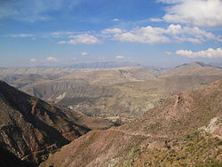
 Cordillera de los Frailes, looking west. Pari Chata (Yocalla Municipality) is on the right in the background, left of it is the Pillku Mayu valley. | |
 Location within Potosí Department | |
| Coordinates: 19°23′S 65°55′W / 19.383°S 65.917°W | |
| Country | |
| Department | Potosí Department |
| Province | Tomás Frías Province |
| Seat | Yocalla |
| Population (2001) | |
| • Total | 8,046 |
| • Ethnicities | Quechua |
| Time zone | UTC-4 (BOT) |
Yocalla Municipality is the second municipal section of the Tomás Frías Province in the Potosí Department in Bolivia. Its seat is Yocalla.
Geography[edit]
Some of the highest mountains of the municipality are listed below:[1]
- Achakana
- Chawpi Urqu
- Jalsuri
- Jatun Pampa
- Jatun Qaqa
- Jatun Q'asa
- Kuntur Nasa
- Kunturiri
- Pari Chata
- Puka Urqu
- T'ula P'ujru
- Waylla Qullu
- Waylla Q'asa
- Wichhu Qullu
- Wila Salla
- Wila Sirka
Subdivision[edit]
The municipality consists of the following cantons:
- Salinas de Yocalla
- Santa Lucia
- Yocalla
The people[edit]
The people are predominantly indigenous citizens of Quechua descent.[2]
| Ethnic group | % |
|---|---|
| Quechua | 93.8 |
| Aymara | 0.4 |
| Guaraní, Chiquitos, Moxos | 0.1 |
| Not indigenous | 5.7 |
| Other indigenous groups | 0.1 |
See also[edit]
References[edit]
External links[edit]


