
Wikipedia:Graphics Lab/Map workshop/Archive/Feb 2013
Stale[edit]
Guys I need a map that indicates with a blue colour Greece, Israel and Cyprus[edit]
There is an article called Energy Triangle and writes about the joint gas explorations and extraction by Israel, Cyprus and Greece! So we need a special locator map that includes all three countries of Southern Europe. I am not expert in Wikipedia so can somebody create it for me?[[ — Preceding unsigned comment added by Kotsia2 (talk • contribs) 10:59, 9 December 2012 (UTC)
Punjab districts[edit]

This map is currently under use by many articles on Punjab. This map is outdated, and since 2008, more districts have been created out of the original district. Please update and replace with a newer version of the map. TheOriginalSoni (talk) 16:20, 16 December 2012 (UTC)
Map of Laura Secord's 1813 walk[edit]
Article: Laura Secord
Request: I'd like to add a legible, free map of Laura Secord's 1813 walk across enemy lines to her article. Here are some sources: [1] [2] [3] [4].
I'm hoping to put the article up for FA in time for the 200th anniversary of Secord's walk in June 2013. Any help would be much appreciated! CuRlyTuRkeyTalkContribs 02:04, 17 December 2012 (UTC)
Graphist opinion(s):
Resolved[edit]
PASL-Pro[edit]
-
 Map of the PASL-Pro

Article(s): Professional Arena Soccer League
Request: Could someone add the Ohio Vortex to the map, they are missing for some reason. Spongie555 (talk) 05:22, 31 January 2013 (UTC)
Graphist opinion: Done but I had some mystifying issues with the thumbnailing, and the image seemed to decompress on upload to the server (it's a 45kB file on my computer). Curious, but it should be irrelevant. ResMar 23:43, 2 February 2013 (UTC)
- Thank you, that is exactly what I needed. Spongie555 (talk) 04:36, 3 February 2013 (UTC)
South Sudan Independence[edit]

Article(s): Decolonization of Africa
Request: Add a new frame at the end to show the independence of South Sudan from Sudan in 2011.
 Done - ArnoldPlaton (talk) 13:07, 20 January 2013 (UTC)
Graphist opinion(s):
Map thumbnail problem[edit]
I recently uploaded a new PNG image intended to overlay the File:USA_Wisconsin_location_map.svg. If I click on the "Full Resolution" link on the PNG image page, I can see my new file (the lines in the upper-right corner continue to the edge of the screen. However, the 585 × 599 preview and "current" thumbnail shown on that page, as well as the 585 × 600 preview and the version of the thumbnail shown here, still render as the 16 March 2012 thumbnail. At first I assumed I just needed to wait for some internal thumbnail generator to get caught up, but now this problem has persisted for almost 24 hours despite my refreshing my screen many times and even dumping all "*.wikipedia.org" cookies (Firefox 18.0). Interestingly, if I view the thumbnail with Internet Explorer 8.0, I see the updated thumbnail.
- Is this a known problem?
- Do I need to do something differently when I upload a new version of an image?
- Should I change something in my browser to fix this?
Thank you for any advice you can offer! Johnson487682 (talk) 15:28, 15 January 2013 (UTC)
- I get the same problem so it's not just your computer. You should bring this up on the technical village pump. --Golbez (talk) 17:03, 15 January 2013 (UTC)
- Thank you for this suggestion. I searched the village pump and found related bug entries: 41130, 31680, and 41113, at least. Apparently, the thumbnail cache servers aren't being completely purged, but the problem only affects certain sized thumbnails from certain geographical servers. So, a 200px thumbnail might look fine to a user in North America but not to a user in Germany. I'll wait a few more days and watch those bug reports for movement. Johnson487682 (talk) 17:46, 15 January 2013 (UTC)
Although the bug (thumbnails don't update) isn't really fixed, thanks to user Brian Wolff for providing a workaround in 41130:
- To force a specific thumbnail to get updated, go to the URL of that thumbnail:
http://upload.wikimedia.org/wikipedia/en/thumb/5/53/USA_Wisconsin_GSUSA_council_boundaries.png/585px-USA_Wisconsin_GSUSA_council_boundaries.png
(found by clicking on the thumbnail link for a particular size on the image's page) - Append "?bypasscache" to the URL to force the varnish server to ignore its cached copy and get the real copy onto the server
http://upload.wikimedia.org/wikipedia/en/thumb/5/53/USA_Wisconsin_GSUSA_council_boundaries.png/585px-USA_Wisconsin_GSUSA_council_boundaries.png?bypasscache - Then change the URL to the actual image page and append "&action=purge"
http://en.wikipedia.org/wiki/File:USA_Wisconsin_GSUSA_council_boundaries.png?action=purge
which forces mediawiki to purge the specific-sized thumbnail that was just loaded. Johnson487682 (talk) 19:56, 24 January 2013 (UTC)
Map for coyote subspecies range[edit]
Article(s): Coyote
Request: The coyote article is going to undergo a re-write, and as part of this project, we need a map delineating the range of all recognised coyote subspecies. The range map on p. 10 of this online book should help: http://archive.org/stream/northamericanqua00nowa#page/10/mode/1up Mariomassone (talk) 14:54, 17 January 2013 (UTC)
Graphist opinion: See File:Coyote subspecies distribution map.svg. Hel-hama (talk) 08:18, 3 February 2013 (UTC)
- There's a random rectangular blotch to the left of the map, mate ;) ResMar 15:42, 3 February 2013 (UTC)
Minor Adjustment Request for Bay Area Rapid Transit, Map of Evening and Sunday Service[edit]
Hi there, in the Bay Area Rapid Transit (BART) article, under the "Hours of Operation" section, I have noticed that there is a map error. According to the BART website (see link below), if travellers are going in the Pittsburg/Bay Point direction from Milbrae, San Bruno actually comes after San Francisco International Airport (SFO), and the original map uploaded on Wikipedia indicated that South San Francisco follows SFO, then San Bruno. This is despite that the Fremont-Daly City and the Richmond-Milbrae lines do not run during the evenings or on Sundays, which is not shown on the map for that reason. I noticed that the editors did correct the Daytime and Saturday service, but failed to look more carefully into the Daytime and Sunday service.
LINKS:
- "Map of Evenings and Sunday Service" (original upload, uncorrected): [5]
- "Map of Daytime and Saturday Service" (revised correction): [6]
- BART's map site (verification only): [7]
I hope that they'll correct the map locations mentioned herein. CHAK 001 (Improvements? Please let me know!) 04:43, 18 January 2013 (UTC)
Oregon rivers map[edit]
-
 The city Baker in the northeast should be Baker City

Article(s): List of rivers of Oregon
Request: This should be a pretty easy fix to make for someone with the right software. The USGS also made a different mistake while making this map (fixed now) but there's still this one to be corrected: Baker should be Baker City. Jsayre64 (talk) 18:52, 10 February 2013 (UTC)
Graphist opinion: Done. I couldn't find an exact font match, but got pretty close. Kmusser (talk) 19:53, 10 February 2013 (UTC)
Needed: example of a map[edit]

Article(s): Brazil
Request: I need an example of a map on Wikipedia with the legenda outside the map itself. I already removed the border and the legenda of the map above (but I haven't uploaded it yet) but the legenda must be added somehow to the picture on the Wikipedia-page itself. I have seen it before how this is done but I cannot recall any map. Wereldburger758 (talk) 12:43, 12 February 2013 (UTC)
Graphist opinion(s): Found an example with File:Poll Closing Times 2008.svg, or see how it's done in an article with the same map with United_States_presidential_election,_2008#Election. Kmusser (talk) 16:59, 12 February 2013 (UTC)
- Yes, that is what I was looking for. Thank you. Wereldburger758 (talk) 17:22, 12 February 2013 (UTC)
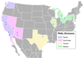
Benefit corporation[edit]
-
 States with B-corp legislation

Article(s): Benefit corporation
Request: The map showing which states have passed benefit corporation legislation needs to be updated. A more recently updated map can be found at [8]. Thanks! I'll try to come back to check on this to help answer questions, if there are any. Please post on my talk page so that I will receive an email notification if I am not prompt.
BTW, I tried updating the map myself, but I couldn't understand the Inkscape software. I think I'll have to leave the map work to the professionals for now.. :P Buttonwillowite (talk) 11:14, 12 December 2012 (UTC)
Graphist opinion(s): Do you know what the colors represent? - Presidentman talk · contribs (Talkback) 12:37, 28 December 2012 (UTC)
Feedback and tweaking of recent governance map[edit]
-
 Map of Polity IV 2011 data displaying the POLITY score, obtained by subtracting the authoritarian score of a country from the respective democracy score. Darkest red is the lowest score (-10), darkest blue the highest(10), purple is zero.
 -
 Previous map.


Article(s): Polity data series
Request: I'm inexperienced with inkscape and can't get Sudan and South Sudan to display correctly. This is also my first upload to wikipedia of an inkscape map so any feedback on color palette or other aesthetics would be appreciated. Relevant data is on the project website or my sandbox --Dishcmds (talk) 18:15, 16 February 2013 (UTC)
Graphist opinion(s):
Why can't you get Sudan and South Sudan to display correctly? I downloaded the map and was able to select both regions in Inkscape. What colours are they supposed to have? Wereldburger758 (talk) 09:53, 17 February 2013 (UTC)
![]() Done: Sorry, I had only tried to update the colors through the css block, I've now updated them myself. --Dishcmds (talk) 10:35, 18 February 2013 (UTC)
Done: Sorry, I had only tried to update the colors through the css block, I've now updated them myself. --Dishcmds (talk) 10:35, 18 February 2013 (UTC)
World Map - Goode Homolosine Projection - Tissot Indicatrices[edit]
-
 A possible base map.

![[1]](http://4.bp.blogspot.com/-KikuK1bWQ80/UKszxac6IlI/AAAAAAAAFYI/sLODE7z5Lpo/s1600/Laura+Secord%27s+Walk0002.jpg)
![[3]](http://professionallyspeaking.oct.ca/december_2011/visuals/PS_News/map.jpg)
![[4]](http://images.ourontario.ca/Partners/nhsm/NHSM072877.jpg)
![[5]](https://en.wikipedia.org/wiki/File:BARTMapNight.svg)
![[6]](https://en.wikipedia.org/wiki/File:BARTMapDay.svg)
Article(s): Goode Homolosine Projection
Request: It would be useful if one of the world maps demonstrating the Goode homolosine projection, such as the map above, was edited to show the Tissot indicatrices of that projection, for comparison to the Tissot indicatrices of other world maps. It would be used on the article discussing the Goode homolosine projection, and any other article that showed a comparison of Tissot indicatrices. --F-Lambda (talk) 03:44, 7 February 2013 (UTC)