Welbourn, New Zealand
Welbourn | |
|---|---|
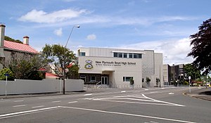
 New Plymouth Boys' High School | |
 | |
| Coordinates: 39°4′10″S 174°5′31″E / 39.06944°S 174.09194°E | |
| Country | New Zealand |
| City | New Plymouth |
| Local authority | New Plymouth District Council |
| Electoral ward |
|
| Area | |
| • Land | 687 ha (1,698 acres) |
| Population (June 2023)[2] | |
| • Total | 3,520 |
| New Plymouth Central | Strandon | Merrilands |
| Brooklands |
|
|
| Brooklands | Highlands Park |
Welbourn (often misspelled Welbourne) is a suburb of New Plymouth, in the western North Island of New Zealand. It is located to the southeast of the city centre. Te Henui Stream runs through the suburb and State Highway 3 forms its western boundary.[3]
The suburb began as a railway settlement.[4]
Demographics[edit]
Welbourn covers 6.87 km2 (2.65 sq mi)[1] and had an estimated population of 3,520 as of June 2023,[2] with a population density of 512 people per km2.
| Year | Pop. | ±% p.a. |
|---|---|---|
| 2006 | 2,796 | — |
| 2013 | 2,997 | +1.00% |
| 2018 | 3,261 | +1.70% |
| Source: [5] | ||
Before the 2023 census, the suburb had a smaller boundary, covering 6.49 km2 (2.51 sq mi).[1] Using that boundary, Welbourn had a population of 3,261 at the 2018 New Zealand census, an increase of 264 people (8.8%) since the 2013 census, and an increase of 465 people (16.6%) since the 2006 census. There were 1,215 households, comprising 1,701 males and 1,563 females, giving a sex ratio of 1.09 males per female. The median age was 40.4 years (compared with 37.4 years nationally), with 648 people (19.9%) aged under 15 years, 609 (18.7%) aged 15 to 29, 1,392 (42.7%) aged 30 to 64, and 612 (18.8%) aged 65 or older.
Ethnicities were 84.6% European/Pākehā, 14.5% Māori, 2.5% Pacific peoples, 7.9% Asian, and 1.6% other ethnicities. People may identify with more than one ethnicity.
The percentage of people born overseas was 18.9, compared with 27.1% nationally.
Although some people chose not to answer the census's question about religious affiliation, 49.7% had no religion, 37.7% were Christian, 0.5% had Māori religious beliefs, 1.5% were Hindu, 1.4% were Muslim, 0.6% were Buddhist and 1.5% had other religions.
Of those at least 15 years old, 573 (21.9%) people had a bachelor's or higher degree, and 450 (17.2%) people had no formal qualifications. The median income was $29,900, compared with $31,800 nationally. 483 people (18.5%) earned over $70,000 compared to 17.2% nationally. The employment status of those at least 15 was that 1,164 (44.5%) people were employed full-time, 456 (17.5%) were part-time, and 81 (3.1%) were unemployed.[5]
Education[edit]
The Western Institute of Technology at Taranaki has its main campus in Welbourn.[6]
New Plymouth Boys' High School is a single-sex state secondary school (years 9–13) with a roll of 1,161 students.[7] The school was built as New Plymouth High School in 1882 and was initially only for boys. It became co-educational in 1885, although the girls were taught separately for the first two years. The girls separated from New Plymouth High School in 1914, forming New Plymouth Girls' High School in Strandon, leaving New Plymouth Boys' High School on the old site.[8]
Central School Te Kura Waenga o Ngāmotu is a coeducational contributing primary (years 1–6) schools with a roll of 262.[9] Central School opened in 1884 and is one of the oldest schools in the region.[10]
Welbourn School is a coeducational contributing primary (years 1-6) school with a roll of 297 students.[11] It was built on railway reserve land in 1932[4] and celebrated its 75th jubilee in 2008.[12]
Rolls are as of February 2024.[13]
Notes[edit]
- ^ a b c "ArcGIS Web Application". statsnz.maps.arcgis.com. Retrieved 8 April 2024.
- ^ a b "Population estimate tables - NZ.Stat". Statistics New Zealand. Retrieved 25 October 2023.
- ^ North Island Provincial Town Maps (5th ed.). Wises Maps. pp. 91, 93.
- ^ a b Murdoch, Janet (2007). "The Railway Leads to Welbourn" (PDF).
- ^ a b "Statistical area 1 dataset for 2018 Census". Statistics New Zealand. March 2020. Welbourn (218300). 2018 Census place summary: Welbourn
- ^ "Our Campuses". Western Institute of Technology. Retrieved 20 February 2021.
- ^ Education Counts: New Plymouth Boys' High School
- ^ "History". New Plymouth Boys' High School. Retrieved 20 February 2021.
- ^ Education Counts: Central School Te Kura Waenga o Ngāmotu
- ^ "Our School". Central School Te Kura Waenga o Ngāmotu. Retrieved 20 February 2021.
- ^ Education Counts: Welbourn School
- ^ "Welbourn School 75th Jubilee". New Plymouth District Council. Archived from the original on 22 October 2008.
- ^ "New Zealand Schools Directory". New Zealand Ministry of Education. Retrieved 14 March 2024.
Further reading[edit]
General historical works[edit]
- Murdoch, Janet (2007). The railway leads to Welbourn: the story of the railway settlement in New Plymouth. New Plymouth, [N.Z.]: Zenith Print & Design. ISBN 978-0-473-13032-9.
Schools[edit]
- Welbourn Carrington Schools, 50th jubilee, 1932-1982. New Plymouth, [N.Z.]: Welbourn School Jubilee Committee. 1982.
