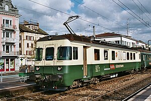
Wädenswil railway station
Wädenswil | ||||||||||||||||||||||||||||||||||||
|---|---|---|---|---|---|---|---|---|---|---|---|---|---|---|---|---|---|---|---|---|---|---|---|---|---|---|---|---|---|---|---|---|---|---|---|---|
 A Südostbahn train on line S13 at the station in 2003 | ||||||||||||||||||||||||||||||||||||
| General information | ||||||||||||||||||||||||||||||||||||
| Location | Wädenswil Switzerland | |||||||||||||||||||||||||||||||||||
| Coordinates | 47°13′45.4800″N 8°40′30.6462″E / 47.229300000°N 8.675179500°E | |||||||||||||||||||||||||||||||||||
| Elevation | 408 m (1,339 ft) | |||||||||||||||||||||||||||||||||||
| Owned by | Swiss Federal Railways | |||||||||||||||||||||||||||||||||||
| Line(s) | ||||||||||||||||||||||||||||||||||||
| Train operators | ||||||||||||||||||||||||||||||||||||
| Connections | Zimmerbergbus bus routes[1] | |||||||||||||||||||||||||||||||||||
| Services | ||||||||||||||||||||||||||||||||||||
| ||||||||||||||||||||||||||||||||||||
| Location | ||||||||||||||||||||||||||||||||||||
Wädenswil railway station is a railway station in Switzerland, situated near to the banks of Lake Zurich in the municipality of Wädenswil in the canton of Zurich. It is located on the Lake Zurich left bank railway line, and is the junction station for the Südostbahn's Wädenswil to Einsiedeln line.[2][3]
The station is served on the lakeside line by an hourly long-distance InterRegio service between Bern and Chur. It is also served by Zurich S-Bahn services S2, S8 and S25 on the lakeside line, and is the terminus of the S13 on the Wädenswil to Einsiedeln line.[4][5]
Services[edit]
As of the December 2021 timetable change,[update] the following services call at Wädenswil:
- InterRegio:
 Aare-Linth: hourly service between Bern and Chur.
- Zürich S-Bahn:
- S2: half-hourly service between Zürich Airport and Ziegelbrücke; on weekends some trains continue to Unterterzen.
- S8: half-hourly service between Pfäffikon SZ and Winterthur;
- S13: hourly service to Einsiedeln via Biberbrugg.
- S25: hourly service between Zürich Hauptbahnhof and Linthal.
- Nighttime S-Bahn (only during weekends):[6]
- SN8: hourly service between Pfäffikon ZH and Lachen (via Zürich HB).
Südostbahn operates the S13 service; Swiss Federal Railways operates the other Zürich S-Bahn services. During weekends, there is also a nighttime S-Bahn services (SN8) offered by ZVV.[7]
References[edit]
- ^ "Regionalnetz | Regional network" (PDF) (in German). ZVV. 15 December 2019. Retrieved 2 July 2020.
- ^ map.geo.admin.ch (Map). Swiss Confederation. Retrieved 2011-11-23.
- ^ Eisenbahnatlas Schweiz. Cologne: Schweers + Wall. 2012. pp. 12–13. ISBN 978-3-89494-130-7.
- ^ "S-Bahn trains, buses and boats" (PDF). ZVV. 9 December 2018. Retrieved 22 September 2019.
- ^ "Zürich - Thalwil - Ziegelbrücke" (PDF) (in German). Bundesamt für Verkehr. 17 October 2019. Retrieved 2 July 2020.
- ^ https://www.zvv.ch/zvv-assets/fahrplan/pdf/nachtnetz.pdf
- ^ https://www.zvv.ch/zvv/en/travelcards-and-tickets/fares/nighttime-network/nacht-fahrplan-und-liniennetz.html
External links[edit]
 Media related to Wädenswil railway station at Wikimedia Commons
- Wädenswil railway station – SBB


