
Vriescheloo
Vriescheloo | |
|---|---|
 Smock mill De Korenbloem in 2008 | |
 Vriescheloo Location of Vriescheloo in the province of Groningen  Vriescheloo Vriescheloo (Netherlands) | |
| Coordinates: 53°4′5″N 7°6′50″E / 53.06806°N 7.11389°E | |
| Country | Netherlands |
| Province | Groningen |
| Municipality | Westerwolde |
| Area (2012)[1] | |
| • Total | 213 ha (526 acres) |
| • Land | 212 ha (524 acres) |
| • Water | 1 ha (2 acres) |
| Population (2021)[2] | |
| • Total | 700 |
| • Density | 330/km2 (850/sq mi) |
| Postcode | 9599[3] |
| Area code | 0597 |
Vriescheloo (Dutch pronunciation: [ˌvrisxəˈloː];[4] Gronings: Vraiskeloo [ˌvrɑɪskəˈloː]) is a village in the municipality of Westerwolde in the Netherlands.
History[edit]
Vrieschloo is a linear settlement on the sand ridge which formed the old road between Groningen and Germany. The village dates from the 11th or 12th century.[5][6] It started as a peat community, and developed into an agriculture community.[5]
The 19th century smock mill De Korenbloem is located in the village.[7]
Gallery[edit]
-
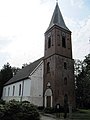 Church in c. 2011
 -
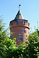 Modern castle
 -
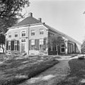 Farm (1969)


References[edit]
- ^ (in Dutch) Kerncijfers wijken en buurten 2017, Statistics Netherlands, 2017. Retrieved on 2 December 2017.
- ^ "Kerncijfers wijken en buurten 2021". Central Bureau Statistics. Retrieved 27 February 2022.
- ^ (in Dutch) Resultaten voor "Vriescheloo,", Postcode.nl. Retrieved on 27 April 2014.
- ^ RTVGO! gemeente Oldambt. "GO op stap met IVN (Kompenkolk nabij Vriescheloo)". YouTube. Retrieved 17 April 2023.
- ^ a b "Vriescheloo". Plaatsengids (in Dutch). Retrieved 27 February 2022.
- ^ Redmer Alma (1998). Vriescheloo. Zwolle: Waanders Uitgevers. p. 219. ISBN 90 400 9258 3.
- ^ "De Korenbloem". Molen Database (in Dutch). Retrieved 27 February 2022.
External links[edit]
 Media related to Vriescheloo at Wikimedia Commons
Neighbouring villages | ||||||||||||||||
|---|---|---|---|---|---|---|---|---|---|---|---|---|---|---|---|---|
| ||||||||||||||||
This Groningen location article is a stub. You can help Wikipedia by expanding it. |