
Volica
Volica | |
|---|---|
Municipality | |
 Church and belfry in Volica | |
 Volica Location of Volica in the Prešov Region  Volica Location of Volica in Slovakia | |
| Coordinates: 49°09′N 21°56′E / 49.150°N 21.933°E | |
| Country | |
| Region | Prešov |
| District | Medzilaborce |
| First mentioned | 1405 |
| Area | |
| • Total | 5.37[2] km2 (2.07[2] sq mi) |
| Elevation | 247[3] m (810[3] ft) |
| Population (2021) | |
| • Total | 266[1] |
| Time zone | UTC+1 (CET) |
| • Summer (DST) | UTC+2 (CEST) |
| Postal code | 067 01[3] |
| Area code | +421 57[3] |
| Car plate | ML |
| Website | www |
Volica (Hungarian: Ökröske) is a village and municipality in the Medzilaborce District in the Prešov Region of far north-eastern Slovakia, in the Laborec Highlands.
History[edit]
In historical records the village was first mentioned in 1405. The name of the village is derived from vôl, vol, "ox", and reflected in its coat of arms.
Geography[edit]
The municipality lies at an altitude of 254 metres and covers an area of 5.373 km². It has a population of 264 people (as of the 2021 census), primarily Rusyns.
Gallery[edit]
-
 Road bridge over the Laborec river, with Volica in the background
 -
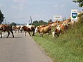 Entering Volica (cattle crossing the road, fittingly for the village's name)
 -
 Front facade of the church in Volica
 -
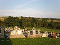 Cemetery in Volica
 -
 Pasture meadow (foreground) and football pitch in Volica (background)
 -
 Main railway line in the Laborec river valley near volica, highlands in the background


References[edit]
- ^ "Počet obyvateľov podľa pohlavia - obce (ročne)". www.statistics.sk (in Slovak). Statistical Office of the Slovak Republic. 2022-03-31. Retrieved 2022-03-31.
- ^ a b "Hustota obyvateľstva - obce [om7014rr_ukaz: Rozloha (Štvorcový meter)]". www.statistics.sk (in Slovak). Statistical Office of the Slovak Republic. 2022-03-31. Retrieved 2022-03-31.
- ^ a b c d "Základná charakteristika". www.statistics.sk (in Slovak). Statistical Office of the Slovak Republic. 2015-04-17. Retrieved 2022-03-31.
- ^ a b "Hustota obyvateľstva - obce". www.statistics.sk (in Slovak). Statistical Office of the Slovak Republic. 2022-03-31. Retrieved 2022-03-31.
External links[edit]
 Media related to Volica at Wikimedia Commons
- Official website

- https://web.archive.org/web/20080111223415/http://www.statistics.sk/mosmis/eng/run.html
Municipalities of Medzilaborce District | ||
|---|---|---|
This Prešov Region geography article is a stub. You can help Wikipedia by expanding it. |