
Vinderhoute
Vinderhoute | |
|---|---|
Village | |
 St Bavo Church | |
 Vinderhoute Location in Belgium | |
| Coordinates: 51°05′14″N 3°38′24″E / 51.0872°N 3.6400°E | |
| Country | |
| Region | Flemish Region |
| Province | East Flanders |
| Arrondissement | Ghent |
| Municipality | Lievegem |
| Area | |
| • Total | 3.67 km2 (1.42 sq mi) |
| Population (2021)[1] | |
| • Total | 1,191 |
| • Density | 320/km2 (840/sq mi) |
| Time zone | CET |
Vinderhoute is a village in the municipality of Lievegem in the province of East Flanders in Belgium. It is located in the Flemish Valley about 6 kilometres (3.7 mi) north-west of Ghent.[2]
History[edit]
Vinderhoute is located in the Flemish Valley on the left bank of the Ghent-Bruges Canal and is surrounded by waterways. A settlement has been discovered from the early La Tène culture near Vinderhoute. The village was first mentioned in 966 as containing a church and farm belonging to the Saint Bavo's Abbey. The heerlijkheid Vinderhoute was one of the oldest fiefs of the County of Flanders.[3]
Vinderhoute was an independent municipality until 1977 when it was merged into Lovendegem.[4] In 2019, it became a deelgemeente of Lievegem.[5]
Buildings and sights[edit]
Schouwbroek Castle was known to exist since 1755. In 1894, it was rebuilt in eclectic style, and a large park was laid out around the castle. Near the entrance are three chestnut trees. One of the trees is the thickest chestnut of Belgium. In 2014, the trees were measured by the Belgian Dendrological Society, and the tree has a trunk circumference of 919 centimetres (362 in), and is possibly the oldest chestnut as well.[6][7]
Vinderhoute Castle was originally a fortified medieval castle. It was demolished and replaced by a manor house in the mid 16th century. It remained inhabited by the Lords of Vinderhoute. During the French Revolution, the heerlijkheid Vinderhoute was disestablished. In the mid-19th century, the estate was extensively renovated. The estate used to have a private road to the parish church.[8]
The Saint Bavo Church was first mentioned in 966. The current church dates was constructed between 1855 and 1856, and is an aisleless neoclassic church with built-in tower. Unlike most churches it is oriented to the south.[9]
The grist mill Van Vlaenderensmolen is a windmill from 1905 located on a slight elevation. The earliest windmill at the site was a wooden mill which was first attested in 1591. The windmill remained in service until 1958, and was later used as a residential house. It was extensively renovated between 2008 and 2009, but most of the inner workings had been removed.[10]
Gallery[edit]
-
 Villa in Vinderhoute
 -
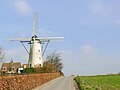 Windmill Van Vlaenderensmolen
 -
 Country side near Vinderhoute
 -
 Schouwbroek Castle
 -
 Chestnut Drove, Castle domain of Vinderhoute


.jpg)

References[edit]
- ^ a b "Bevolking per statistische sector - Sector 44036B". Statistics Belgium. Retrieved 6 May 2022.
- ^ "Distance Vinderhoute, Lievegem, BEL -> Ghent, BEL". Distance.to (in Dutch). Retrieved 6 May 2022.
- ^ "Vinderhoute". Agentschap Onroerend Erfgoed (in Dutch). Retrieved 6 May 2022.
- ^ "Lovendegem". Agentschap Onroerend Erfgoed (in Dutch). Retrieved 6 May 2022.
- ^ "Lievegem". Vlaanderen.be (in Dutch). Retrieved 6 May 2022.
- ^ "Kasteel Schouwbroek". Ontdek Drongen (in Dutch). Retrieved 6 May 2022.
- ^ "Kasteeldomein Schouwbroek". Vlaanderen.be (in Dutch). Retrieved 6 May 2022.
- ^ "Kasteel van Vinderhoute, Lovendegem". Meetjes Land (in Dutch). Retrieved 6 May 2022.
- ^ "Parochiekerk Heilige Bavo en kerkhof". Vlaanderen.be (in Dutch). Retrieved 6 May 2022.
- ^ "Vinderhoute (Lievegem), Oost-Vlaanderen". Molen Echos (in Dutch). Retrieved 6 May 2022.
Belgian municipality Lievegem | |
|---|---|
| Deelgemeentes | |