
Vaige
| Vaige | |
|---|---|
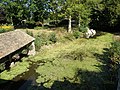
 Vaige river at the south of La Bazouge-de-Chemeré in winter | |
  | |
| Location | |
| Country | France |
| Physical characteristics | |
| Source | |
| • location | Saint-Léger |
| • coordinates | 48°04′52″N 00°28′15″W / 48.08111°N 0.47083°W |
| • elevation | 112 m (367 ft) |
| Mouth | |
• location | Sarthe |
• coordinates | 47°50′15″N 00°19′55″W / 47.83750°N 0.33194°W |
• elevation | 24 m (79 ft) |
| Length | 53.6 km (33.3 mi) |
| Basin size | 233 km2 (90 sq mi) |
| Discharge | |
| • average | 1.48 m3/s (52 cu ft/s) |
| Basin features | |
| Progression | Sarthe→ Maine→ Loire→ Atlantic Ocean |
The Vaige (French pronunciation: [vɛʒ]) is a 53.6 km (33.3 mi) long river in the Mayenne and Sarthe departments in western France.[1]
This list is ordered from source to mouth:
- In Mayenne, the Vaige has its source in Saint-Léger then waters the following villages: Vaiges, Saint-Georges-le-Fléchard, La Bazouge-de-Chemeré, La Cropte, Saint-Denis-du-Maine, Préaux, Ballée, Beaumont-Pied-de-Bœuf,
- Then the Vaige séparates Mayenne (Saint-Loup-du-Dorat) from Sarthe (Auvers-le-Hamon),
- Only in Mayenne the Vaige waters Bouessay,
- Entering the Sarthe department, the Vaige avoid the Sablé-sur-Sarthe town and flows in the Sarthe (right tributary)
Low water and flood[edit]
Very often the river uses to dry at the end of summer and the beginning of autumn, so fishes and river mussels die but kingfishers may fly away.[citation needed]
-
 the Vaige dried at the south of the Bazouge-de-Chemeré on September 17, 2005
 -
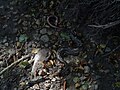 Died fishes in the dried river on 2005
 -
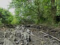 the Vaige dried at the south of the Bazouge-de-Chemeré on June 24, 2017
 -
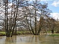 Flood at the south of the Bazouge-de-Chemeré on February 28, 2010
 -
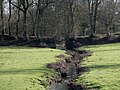 The Chemerette stream passes through an old path before flowing in Vaige river.
 -
 Wash-house in La Cropte


References[edit]
This Mayenne geographical article is a stub. You can help Wikipedia by expanding it. |
This Sarthe geographical article is a stub. You can help Wikipedia by expanding it. |