
User talk:P199/Archive 3
DO NOT EDIT TANAUAN[edit]
Please do not edit and edit TANAUAN RELIGION SECTION. SENAKULO & ANG LIHIM NG FATIMA is very IMPORTANT IN TANAUAN — Preceding unsigned comment added by Tanginanyo (talk • contribs) 08:33, 19 September 2012 (UTC)
- If you feel that I am removed too much, then only add info you feel should be there. Don't revert because I made many other changes that improve the article. Moreover, none of your additions have any reputable in-line citations, one of WP most important requirements. -- P 1 9 9 ✉ 14:04, 19 September 2012 (UTC)
Disambiguation link notification[edit]
Hi. When you recently edited Matane, you added a link pointing to the disambiguation page Mi'kmaq (check to confirm | fix with Dab solver). Such links are almost always unintended, since a disambiguation page is merely a list of "Did you mean..." article titles. Read the FAQ • Join us at the DPL WikiProject.
It's OK to remove this message. Also, to stop receiving these messages, follow these opt-out instructions. Thanks, DPL bot (talk) 10:48, 24 January 2012 (UTC)
Taiwan (disambiguation)[edit]
Since you were involved in Talk:Taiwan (disambiguation), you may also be interested in Wikipedia:Articles_for_deletion/Taiwan_island_group, since it is one of the items listed at the disambiguation page. Huayu-Huayu (talk) 16:01, 24 January 2012 (UTC)
Mattawa, Ontario (2011 Census)[edit]
Hi. The census numbers that I obtained for Mattawa can be found here: http://www12.statcan.gc.ca/census-recensement/2011/dp-pd/prof/details/page.cfm?Lang=E&Geo1=CSD&Code1=3548021&Geo2=CD&Code2=3548&Data=Count&SearchText=mattawa&SearchType=Begins&SearchPR=01&B1=All&Custom=&TABID=1. I believe that the numbers for the town itself ("Census Subdivision") seem more appropriate than the "Population Centre" numbers that you have posted. The Census Subdivision numbers also match up with the 2006 population that was already listed in the article -- the Population Centre numbers for 2006 again show 10 more people.
I won't automatically change the census numbers back, since I know that both your edits as well as mine were made in good faith, and I don't want to appear as though I am starting an edit war. I apologize that I did not include my source while making my original edits -- that was definitely an error on my part -- but I do believe that the Town/Census Subdivision numbers are more accurate than the Population Centre numbers, which refer to the urban core, regardless of town boundaries.
Cheers.
- You are right, I used the wrong link! I'll make the update. Thanks for pointing this out. -- P 1 9 9 • TALK 14:44, 10 February 2012 (UTC)
Whitewater[edit]
Hi, can you send me this in a better resolution? What grade is it? to project...OpenSeaMap.org Thanks, Markus — Preceding unsigned comment added by 91.8.134.74 (talk) 21:08, 23 February 2012 (UTC)
- Thanks for your interest in my picture. Unfortunately, it is not available in a better resolution because it is an enlargement of a larger photo on which the canoe already is fairly small. It is a scan, the original was film, not digital. It shows the Crooked Chute on the Petawawa River, officially rated a Class-IV. -- P 1 9 9 • TALK 21:51, 23 February 2012 (UTC)
Quebec infoboxes[edit]

You can remove this notice at any time by removing the {{Talkback}} or {{Tb}} template.
-- P.T. Aufrette (talk) 12:35, 2 April 2012 (UTC)
There hasn't been a lot of reaction so far at Wikipedia talk:WikiProject Quebec. It may be that we are the only two people working systematically on Quebec municipalities infoboxes. Maybe we discuss it informally. Here's what I've been doing, more or less:
- I have an automated tool that re-orders the lines in the Infobox settlement template, to the order given in the template's documentation. This enables easily finding the appropriate line in the expected place, and prevents problems with, for instance, the same field accidentally being entered twice (I've seen that already a number of times, especially for settlement_type; in this case the second occurrence overrides the first). I'm running it in a separate preliminary pass before doing other modifications.
- In addition to re-ordering the lines, it wipes out all _miles and _feet fields. The template itself automatically does the conversion, so having these filled in only creates the possibility of inconsistencies, if the land area has changed for whatever reason, and the km2 got updated but the sq_mi field didn't.
- I've been doing that as well, including other unused fields such as metro and urban info for small rural places.
- I am working on a tool that can populate the Infobox settlement fields a little more automatically, by screen-scraping data from the Census website and MAMROT site.
- This is something I would have like to see for all Canada, similar to {{Population Dutch municipality by code}}.
- What I meant by this was simply having a bot visit the Statistics Canada site, extract the number, and then paste it into the given field in the Wikipedia article. I don't think that Dutch template approach would work, because it only has a limited number of Dutch municipalities, while there are over 1000 Quebec municipalties.
- This is something I would have like to see for all Canada, similar to {{Population Dutch municipality by code}}.
- Since nearly every page needs MAMROT and Census links, and often Toponymie links, maybe the standard place to put them would be in the References section. I.e.,
==References==
{{Reflist|refs=
<ref name="cp2011">...</ref>
<ref name="mamrot">...</ref>
<ref name="toponymie">...</ref>
}}
That avoids putting long URL clutter in the infobox itself, those can just use short [1] format everywhere.
- True, but these links are or should be already there through the use of inline references, like Portage-du-Fort, Quebec.
- These links are used in many places, but the problem is that the definitions are often in different places. For instance, in some articles
<ref name="cp2011">is defined in area_footnotes, in other articles it's defined in population_footnotes, in others it's defined inline in the article text. It would be nice to standardize a single place for the definition, and the Reflist|refs seems like a good place. It reduces the inline clutter in the infobox and the article text.
- These links are used in many places, but the problem is that the definitions are often in different places. For instance, in some articles
- True, but these links are or should be already there through the use of inline references, like Portage-du-Fort, Quebec.
Regarding the other fields:
{{Infobox settlement
<!-- See Template:Infobox settlement for additional fields and descriptions -->
| name                    = Should be just "Mytown", not "Mytown, Quebec"
                            Should be common English name (eg, Mount Royal) for the few cases different from French name.
                            A good standard would be what the Montreal Gazette would use
| official_name           = rarely needed, only if actual usage or spelling ignores Commission de toponymie
                            (eg, Dollard-Des Ormeaux vs. Dollard-des-Ormeaux, or Belœil vs. Beloeil)
                            If used, should be Village de X, Ville de X, Paroisse de X, Canton de X
                            (or Municipalité de paroisse de X, Municipalité de canton de X, if the town website prefers it).
| native_name             = rarely needed, only for cases like Mont-Royal vs. Mount Royal, where the French name differs from the English name
| native_name_lang        = fr (but only if native_name was specified)
| other_name              = rarely needed, perhaps if there is a former name and it was recently changed,
                            then "<small>Formerly</small> Oldville"
| settlement_type         = [[Village municipality (Quebec)|]], [[Parish municipality (Quebec)|]],
                            [[Township municipality (Quebec)|]], [[United township municipality (Quebec)|]],
                            [[City (Quebec)|]],
                            all of which are currently just redirects to [[Types of municipalities in Quebec]]
<!-- transliteration(s) -------->
| translit_lang1          = None of these are needed
| translit_lang1_type     =
| translit_lang1_info     =
| translit_lang1_type1    =
| translit_lang1_info1    =
| translit_lang1_type2    =
| translit_lang1_info2    =
| translit_lang2          =
| translit_lang2_type     =
| translit_lang2_info     =
| translit_lang2_type1    =
| translit_lang2_info1    =
| translit_lang2_type2    =
| translit_lang2_info2    =
| translit_lang2_info2    =
<!-- images, nickname, motto --->
| image_skyline           =
| imagesize               =
| image_alt               =
| image_caption           =
| image                   =
| image_flag              =
| flag_size               =
| flag_alt                =
| flag_link               =
| image_seal              =
| seal_size               =
| seal_alt                =
| seal_link               =
| image_shield            =
| shield_size             =
| shield_alt              =
| shield_link             =
| image_blank_emblem      =
| blank_emblem_type       =
| blank_emblem_size       =
| blank_emblem_alt        =
| blank_emblem_link       =
| nickname                =
| motto                   = optional, if there is one
| anthem                  =
<!-- maps and coordinates ------>
| image_map               =
| mapsize                 =
| map_alt                 =
| map_caption             =
| image_map1              =
| mapsize1                =
| map_alt1                =
| map_caption1            =
| image_dot_map           =
| dot_mapsize             =
| dot_map_base_alt        =
| dot_map_alt             =
| dot_map_caption         =
| dot_x = |dot_y =
| pushpin_map             = Canada Quebec
| pushpin_label_position  = left, right, top, bottom
| pushpin_label           = <!-- only necessary if "name" or "official_name" are too long -->
| pushpin_map_alt         =
| pushpin_mapsize         = 197  (rather than 200, because there is a pre-made image of that width already)
                            --- NO DIFFERENCE, IT LINKS TO SAME SVG IMAGE (???)
                            ------ Well, at [[:File:Canada Quebec location map 2.svg]] it mentions that
                                   it is available in other resolutions, including 197x240. So setting 197 uses it directly,
                                   whereas with a different size the server has more work to do, I think.
| pushpin_map_caption     =    (only if map_caption was specified and we don't want that text to reappear
                                     under the pushpin map)
| pushpin_map1            =
| pushpin_label_position1 =
| pushpin_label1          =
| pushpin_map_alt1        =
| pushpin_mapsize1        =
| pushpin_map_caption1    =
| latd  =  |latm  =  |lats  =  |latNS  =  See longer discussion elsewhere
| longd =  |longm =  |longs =  |longEW =  See longer discussion elsewhere
| coor_pinpoint           = The street address in the "Coordonnées" area of the MAMROT page
                            --- TOWN HALL ADDRESS, SEE [[WP:NOTDIRECTORY]]
                            ------- But the point is not to provide a directory listing of town hall addresses;
                                    it is simply to provide a guaranteed-relevant starting point for a
                                    Google street view or aerial view exploration of the heart of
                                    the given municipality.
| coordinates_region      = CA-QC
| coordinates_type        =
| coordinates_display     = inline,title
| coordinates_format      = I'd rather have this blank, rather than "dms"
| coordinates_footnotes   =
<!-- location ------------------>
| subdivision_type        = Country   (no real need for a link like [[Countries of the world|Country]])
| subdivision_name        = {{CAN}}
| subdivision_type1       = [[Provinces and territories of Canada|Province]]
| subdivision_name1       = {{QC}}
| subdivision_type2       = [[Region (Quebec)|Region]]
| subdivision_name2       = eg, [[Bas-Saint-Laurent]]
| subdivision_type3       = [[Regional county municipality|RCM]]
| subdivision_name3       = eg, [[Pontiac Regional County Municipality|Pontiac]]
<!-- established --------------->
| established_title       = <!-- Settled --> if applicable
| established_date        =
| established_title1      = Constituted, per http://www2.publicationsduquebec.gouv.qc.ca/dynamicSearch/telecharge.php?type=2&file=/O_9/O9_A.html
| established_date1       = January 1, 1900
| established_title2      =
| established_date2       =
| established_title3      =
| established_date3       =
| extinct_title           = Amalgamated or Annexed, per http://www2.publicationsduquebec.gouv.qc.ca/dynamicSearch/telecharge.php?type=2&file=/O_9/O9_A.html
| extinct_date            = January 1, 2000
| founder                 = if applicable
| named_for               = if applicable, eg, [[Henry Hope (Quebec lieutenant-governor)|]] for [[Hope, Quebec]]
                            per Commission de toponymie.
<!-- seat, smaller parts ------->
| seat_type               = For an MRC, this would be the "county seat" municipality; for a local municipality, it would be blank.
| seat                    = Should not be used for federal or provincial electoral districts, which is contrary to the template documentation
| parts_type              = Boroughs (for the municipalities in [[List of boroughs in Quebec]]
| parts_style             = (these have already been filled in for those municipalities)
| parts                   =
| p1                      =
| p2                      =
<!-- government type, leaders -->
| government_footnotes    = <ref name="mamrot"/>
| government_type         = this could be [[Mayor–council government]], or just left blank.  NOT a repeat of settlement_type
| governing_body          = for Quebec itself, [[National Assembly of Quebec]], for anything else just blank
| leader_party            = for municipalities that have municipal parties, eg, Montreal
| leader_title            = Mayor (should only be linked if there is an appropriate page, eg [[List of mayors of Montreal|Mayor]])
| leader_name             = Mayor's name, from MAMROT, under "Organisation"
                            No need to list city councillors in the fields below
| leader_title1           = [[List of Canadian federal electoral districts|Federal riding]]
| leader_name1            = the name of the district (linked) only, not the name of the MP
                            (it's unwieldy to change frequently for 1100+ municipalities...
                             we still have a lot of Bloc Québécois MPs, nearly a year after the election!)
| leader_title2           = [[List of Quebec provincial electoral districts|Prov. riding]]
| leader_name2            = the name of the district (linked) only, not the name of the MNA
<!-- display settings  --------->
| total_type              =
| unit_pref               = -- DELETE THIS LINE (metric is the default, and primary sources supply metric data)
<!-- area ---------------------->
| area_footnotes          = <ref name="mamrot"/><ref name="cp2011"/>
| area_magnitude          =
| area_total_km2          = from MAMROT
| area_total_sq_mi        = -- DELETE THIS LINE, for all _mi and _ft fields; they just create inconsistencies with automatic conversion
| area_total_dunam        = <!-- used in Middle East articles only -->
| area_land_km2           = from Census
| area_land_sq_mi         =
| area_water_km2          =
| area_water_sq_mi        =
| area_water_percent      =
| area_urban_footnotes    =
| area_urban_km2          =
| area_urban_sq_mi        =
| area_rural_footnotes    =
| area_rural_km2          =
| area_rural_sq_mi        =
| area_metro_footnotes    = <ref name="cp_agg_2011"/>  (or something like that)
| area_metro_km2          = for the 28 cities like Alma, Amos, etc. that are also Census Agglomerations
| area_metro_sq_mi        =
| area_rank               =
| area_blank1_title       =
| area_blank1_km2         =
| area_blank1_sq_mi       =
| area_blank2_title       =
| area_blank2_km2         =
| area_blank2_sq_mi       =
| area_note               = In a number of cases (especially for small-in-area villages),
                            the total land+water area reported by MAMROT is actually less than the land area alone reported by Statcan!
                            In those cases, I put a standard message here:
                            "There is an apparent contradiction between two authoritative sources"
<!-- elevation ----------------->
| elevation_footnotes     = <!-- for references: use <ref> tags -->
| elevation_m             =
| elevation_ft            =
| elevation_max_footnotes = <!-- for references: use <ref> tags -->
| elevation_max_m         =
| elevation_max_ft        =
| elevation_min_footnotes = <!-- for references: use <ref> tags -->
| elevation_min_m         =
| elevation_min_ft        =
<!-- population ---------------->
| population_footnotes    = <ref name="cp2011"/>  (and also <ref name="cp_agg_2011"/> for the 28 cities that are also census agglomerations
| population_total        = the value for the census subdivision (statcan URL with "CSD")
| population_as_of        = 2011
| population_rank         =
| population_density_km2  = the value for the census subdivision (statcan URL with "CSD")
| population_density_sq_mi=
| population_est          =
| pop_est_as_of           =
| population_urban        =
| population_density_urban_km2   =
| population_density_urban_sq_mi =
| population_rural        =
| population_density_rural_km2   =
| population_density_rural_sq_mi =
| population_metro        = the value for the census agglomeration (statcan URL with "CMA"),
                            for the 28 cities that are census agglomerations
| population_density_metro_km2   = the value for the census agglomeration (statcan URL with "CMA"),
                                   for the 28 cities that are census agglomerations
| population_density_metro_sq_mi =
| population_density      =
| population_density_rank =
| population_blank1_title = Change <small>(2006–11)</small>    ----- DUPLICATION OF {{CANADA CENSUS}} TEMPLATE (IF USED)
| population_blank1       = {{increase}}1.2%  or {{decrease}}3.5%  or 0.0%   --- DUPLICATION OF {{CANADA CENSUS}} TEMPLATE (IF USED)
| population_density_blank1_km2  =
| population_density_blank1_sq_mi=    --- DELETE LINE
| population_blank2_title = Dwellings
| population_blank2       = the "total private dwellings" field from Statcan   --- DUPLICATION OF {{CANADA CENSUS}} TEMPLATE (IF USED)
| population_density_blank2_km2  =
| population_density_blank2_sq_mi=    --- DELETE LINE
| population_demonym      = rarely used; avoid simply copying French gentilés from MAMROT page, which aren't necessarily used in English
| population_note         =
<!-- demographics (section 1) -->
                          These are currently blank, but perhaps could be used as below?
                          Note: this data hasn't been released yet for the 2011 census
                          --- THIS WOULD MAKE INFOBOX SO LONG.
                              BETTER TO USE DEMOGRAPHICS SECTION IN MAIN BODY OF TEXT.
| demographics_type1      = Mother tongue
| demographics1_footnotes = <ref name="cp2011"/>
| demographics1_title1    = French
| demographics1_info1     = NN.N%
| demographics1_title2    = English
| demographics1_info2     = NN.N%
| demographics1_title3    = Other
| demographics1_info3     = NN.N%
<!-- demographics (section 2) -->
| demographics_type2      =
| demographics2_footnotes =
| demographics2_title1    =
| demographics2_info1     =
<!-- time zone(s) -------------->
| timezone1               = [[Eastern Standard Time|EST]]  (only Côte-Nord east of 63°W uses [[Atlantic Standard Time|AST]])
| utc_offset1             = -5
| timezone1_DST           = [[Eastern Daylight Time|EDT]]  (the few locations that use AST do not observe daylight saving time)
| utc_offset1_DST         = -4
| timezone2               =
| utc_offset2             =
| timezone2_DST           =
| utc_offset2_DST         =
<!-- postal codes, area code --->
| postal_code_type        = [[Canadian postal code|Postal code]]
| postal_code             = could be linked as [[List of J postal codes of Canada|J0J 0J0]], or just plain and unlinked;
                            a full postal code for small municipalities, or just the first three characters for an urban municipality,
                            or [[List of H postal codes of Canada|H postal codes]] for Montreal, etc.
| postal2_code_type       =
| postal2_code            =
| area_code_type          = blank or omitted, defaults to Area code(s)
| area_code               = [[Area code 418|418]]  (or [[Area codes 418 and 581|418 and 581]])
| geocode                 = blank or omitted, per the template documentation, this isn't the same as the geographic code used by Statcan
| iso_code                =
| registration_plate      =
<!-- twin cities --------------->
                            this seems like clutter
| twin1                   =
| twin1_country           =
| twin2                   =
| twin2_country           =
<!-- blank fields (section 1) -->
                            this is already in use for access roads and highways, I leave that undisturbed
                            --- I'VE LEFT IT AS IS TOO,
                                 BUT MY PREFERENCE IS TO REMOVE IT AND ADD A PROPER TRANSPORTATION/ROADS SECTION IN TEXT.
| blank_name_sec1         =
| blank_info_sec1         =
| blank1_name_sec1        =
| blank1_info_sec1        =
| blank2_name_sec1        =
| blank2_info_sec1        = <!-- etc., up to blank7_name_sec1 / blank7_info_sec1 -->
<!-- blank fields (section 2) -->
                            This is where I was putting the Census, MAMROT and Toponymie codes, but have stopped for now
                            They have only been added for maybe a dozen or so villages in [[:Category:Villages in Quebec]]
| blank_name_sec2         =
| blank_info_sec2         =
| blank1_name_sec2        =
| blank1_info_sec2        =
| blank2_name_sec2        =
| blank2_info_sec2        = <!-- etc., up to blank7_name_sec2 / blank7_info_sec2 -->
<!-- website, footnotes -------->
| website                 = should be {{URL|example.com}}, from the MAMROT page; sometimes there isn't one
| footnotes               =
}}
See my answers/comments above in bold or ALLCAPS. -- P 1 9 9 • TALK 00:59, 5 April 2012 (UTC)
- OK, where we're in agreement, I edited out commentary, with a view to this possibly becoming an eventual draft guideline. -- P.T. Aufrette (talk) 02:17, 5 April 2012 (UTC)
Update[edit]
I've made some progress with the tool that grabs data from the Census and MAMROT and Toponymie sites. It still needs to be run manually, and has needed a lot of debugging, but I think it's now at a point where I can start rapidly updating the infoboxes, perhaps a hundred or more per day. For the moment I am mostly grabbing the latitude and longitude information from the Commission de toponymie site to save time because the Google Maps step requires extra manual intervention, but I still think the extra precision is useful where applicable.
In any case, only the infoboxes are being updated; the article text obviously is free-form and can't be updated in any semi-automated fashion. If you're interested, all of the articles in Category:Villages in Quebec and Category:Township municipalities in Quebec have updated infoboxes, and I'm running through Category:Parish municipalities in Quebec at the moment. Perhaps in a few days we could post on WP:QC to see if any volunteers want to organize systematic editing and updating of the article texts (there are about 1100 municipalities in total). -- P.T. Aufrette (talk) 16:51, 11 April 2012 (UTC)
Commission de toponymie coordinates[edit]
For both Lac-Metei, Quebec and Matchi-Manitou, Quebec (which are unorganized territories, the latitude and longitude position given at the Commission de toponymie du Québec pages reflects positions within their pre-1996 territories, not their present-day greatly-reduced territories. I think that just reflects the fact that the Commission's mission is naming, not providing an up-to-date or exact database of latitude and longitude coordinates. So I think it makes sense to overrule the Commission's coordinates in some cases. -- P.T. Aufrette (talk) 02:25, 18 April 2012 (UTC)
possible origins of St. Thomas, Quebec name[edit]
After much searching, I have traced a relative who came to live in St. Thomas in 1810. He came from the island of Jersey which is part of the Channel Islands, between France and England. He was french. I wondered why he would come from the Channel Islands to St. Thomas. But upon reading that part of St. Thomas was named Jersey it made sense that PERHAPS a group of people from the isle of Jersey lived there and so he would follow people he knew or had acquaintance with. I'm sorry I don't have sources and this is all just conjecture but I'm hoping it might lead to possibly more clarification. 70.67.214.7 (talk) 22:42, 12 May 2012 (UTC) 15:42 12 May 2012 — Preceding unsigned comment added by 70.67.214.7 (talk) 22:40, 12 May 2012 (UTC)
- See http://www.saintthomas.qc.ca/index.php?option=com_content&task=view&id=24&Itemid=10 as a possible source of info for you. -- P 1 9 9 • TALK 13:17, 14 May 2012 (UTC)
Image removals in Mechanical fan article[edit]
Since you appear to be a regular editor and not a vandal I am writing this reply rather than merely reverting your deletions. I disagree with your image removals at the end of the article because the images are specific examples of what is mentioned in the text, belt-drive and double-axle-drive. These are not obvious details shown or highlighted in the other images.
Directing people to the Commons is more for "look here to find similar examples of what has been shown here". DMahalko (talk) 02:46, 4 July 2012 (UTC)
A barnstar for you![edit]

|
The Special Barnstar |
| Thank you for cleaning up Cabuyao, Laguna's article! Jonathan Manangkil Hinagpis (talk) 01:59, 25 August 2012 (UTC) |
Maraming salamat. Nice to be appreciated. -- P 1 9 9 ✉ 04:23, 25 August 2012 (UTC)
Hot Cat discussion at VPP[edit]
Thank you for your interest in the discussion at Wikipedia:Village_pump_(proposals)#Proposal:_enable_HotCat_for_all_editors_by_default. Please note that I have now proposed 5 different, more nuanced versions of the original suggestion, to better gauge to what level (if any) we are willing to make Hot Cat more accessible. --Piotr Konieczny aka Prokonsul Piotrus| reply here 16:39, 24 September 2012 (UTC)
Disambiguation link notification for October 16[edit]
Hi. Thank you for your recent edits. Wikipedia appreciates your help. We noticed though that when you edited Larena, Siquijor, you added a link pointing to the disambiguation page EDSA Revolution (check to confirm | fix with Dab solver). Such links are almost always unintended, since a disambiguation page is merely a list of "Did you mean..." article titles. Read the FAQ • Join us at the DPL WikiProject.
It's OK to remove this message. Also, to stop receiving these messages, follow these opt-out instructions. Thanks, DPL bot (talk) 11:10, 16 October 2012 (UTC)
A cheeseburger for you![edit]

|
Hello, thanks for the star you bestowed upon me. I wish I could meet you someday.
Let me clarify on my edits, with all due respect: a) I am only into photography, and I don't desire to expand articles; b) however, Wikipedia rules vis-a-vis good articles, must have proportional number of images to the number of paragraphs with links; c) as you notice, I never complained nor revert any edits of my images inserted, since I state that Wikipedia is a continuous edit thing; I have no monopoly of my edit or the article; in face best articles are edited by more that 1,000 edits by editors; d) here in Philippines, it is so stressful to expand articles just to put in my images in proportion, as you duly noted; d) but most of the times, the server and internet here are so slow; e) rest assured that if pc gets fast and I would have no stressful times, I will try to expand the articles that I inserted the images. As pattern I desire to emulate Valenzuela, Philippines or any other better Philippine town article. I greatly appreciate your creating categories for my images. As you notice, I only put 1 category, since, the computer is so slow and if the images fail to upload, I would need about 5 hours just for 7 images. Finally, I desire to finish Bulacan, Nueva Ecija and Aurora, inter alia. I deeply understand that many images are bad for a short paragraph or sentence of an article. But, but and but, for example, a town must have at least 4 images of a heritage town hall, 4 or 5 for a church, and at least 1 for the major points like heritage schools, banks, etc. Cheers.--Ramon FVelasquez (talk) 07:13, 7 November 2012 (UTC) |
On the Calamba article, et al[edit]
I share the same sentiment with you regarding fanaticism on almost all Philippine city and municipality articles. I had a long Wiki-break though but before that I was quite active in weeding peacock words out. Anyway, on your latest concern, I have quite the experience dealing with editors who are just not in favor of articles that they seem to own (see some of their "love letters" here) . You can try reporting problematic editors to the 3RR noticeboard if AIV seems premature at the mean time. I'd be glad to join you in your quest to purge these articles of nonsense. You can always check out the tambayan for help. In any case, I'll be editing the Calamba article immediately. Xeltran (talk) 11:19, 11 November 2012 (UTC)
- Thanks Xeltran. I have already started a discussion at Administrators' noticeboard and article talkpage. Maybe you can contribute some comments there as well? -- P 1 9 9 ✉ 14:37, 12 November 2012 (UTC)
Hi, my gallery[edit]
I was advised months ago to put my tons of images in the gallery of show and hide. I share the sentiment of yours, that I put to many images, when the article is barely on its better state of expansion, with just few links and very few sentences, stubs, so to speak. Hence, I opted to put these precious images of heritage districts and churches in Wikipedia hide and show gallery. I know that this style for imagery is very detrimental to those Filipinos who are not so keen or knowledgeable about internet, like the old horses, the professionals who use manual typewriters. But most of my edits or rather 70% of them use the show image gallery, too many images. I am not offended if any editor would edit my images, for I know that I am only 1 of the editors of the evolving articles. Cheers and thanks for your thoughts that I learned to improve Wikipedia imaging (See for example The Metropolitan Cathedral of San Fernando Image Gallery). Cheers again.--Ramon FVelasquez (talk) 08:40, 12 November 2012 (UTC)
- Thanks Ramon. Another solution I prefer is to place the images in 1 category on Commons and then add a link to the Commons category, like I did for Arayat, Pampanga. If you need help with this, let me know. Regards, -- P 1 9 9 ✉ 14:37, 12 November 2012 (UTC)
- Welcome and I appreciate your great help for us. It is sad that I failed to take more pictures of Arayat. My mistake is I thought it is a low class place only to discover that it is one of the biggest and most beautiful in Pampanga. I was deceived by the dirty town hall and dire poverty of the scene. When I shoot Magalang, Pampanga, I passed Arayat's most beautiful scenes. Now I learned my lesson, to shoot many Commons pictures, put them in the gallery, and let editors trim them down and/or put them in the gallery hide and show amid better links and paragraphs. It is sad that after creating the Pampanga town articles, they remain start stubs, and I have to expand them, even if I am only interested in photography. Even our Philippine Department of Tourism and more sad, each of the Town tourism offices miserably failed to guide me on the landmarks. Thus, I have to go to the internet and search to expand. You will notice, that before I put so many Categories in Commons, but now only 1 Category and the name description often short. The reason is, our internet and even Wikipedia's upload Wizzard vis-a-vis Word and Google Chrome often hang and are so slow. Imagine a time when I upload 10 images in 1 hour. And after waiting for 1 hour, they collapse only forcing me to repeat. Thus, I appreciate your help in creating or Categorizing my images. I would rather concentrate in shooting the images, and then, if time permits, I would expand the articles with links, and leave the matter of improvement of the articles to protected and featured articles via improving the Wikipedia reference format in time. Thanks again, and I request thee, to examine the most beautiful photos of our National Cultural Treasures, the 400 years old some of the 26 Heritage Churches, houses and sites. You can be there in the future, they are priceless. For me, Wikipedia and Commons, via my pictures, can state for certain, that we do have solely the images that even our Department of Tourism failed to shoot, these remote Town treasures. Cheers and thanks again.--Ramon FVelasquez (talk) 06:03, 13 November 2012 (UTC)
Dusseldorf template deletion[edit]
Hi there. Any further word on if Template:Düsseldorfer EG roster is going to be deleted or not? Per the nomination page. Thanks! saint0wen (talk) 06:27, 15 November 2012 (UTC)
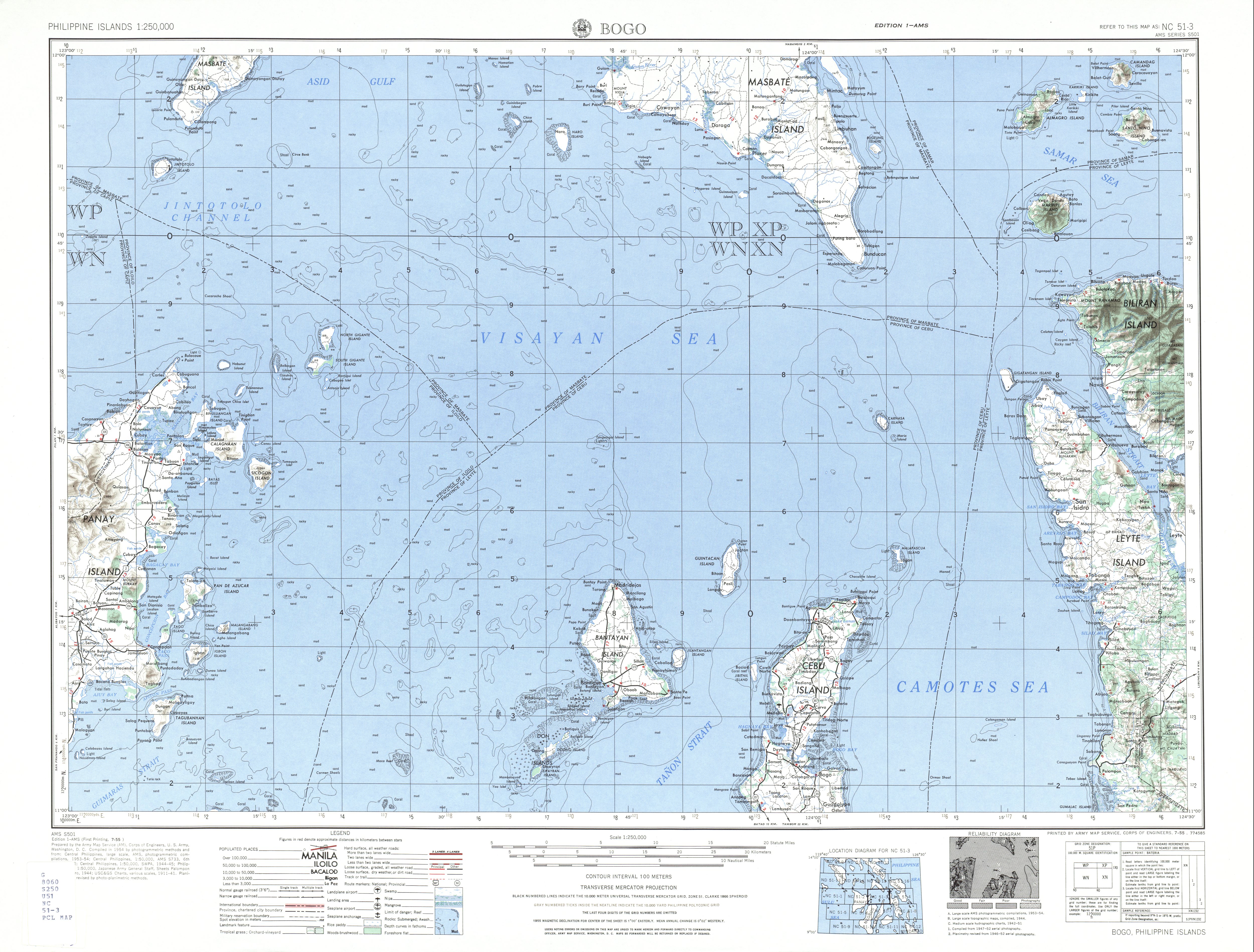
You inserted a picture here in 2009. On the caption you include 'Bitoon' as one of its barangays. I can't see any reference to that as such, although the barangays of Daanbatayan includes one Bitoon, and according to the map there, Bitoon is central north. So I think you're mistaken.
According to PSGC, the three barangays on Guintacan are Hagdan, Kinatarkan and Langub.
I'm kind of surprised that Guintacan island is within Bantayan Island (Santa Fe) administration rather than Daanbantayan's. — Preceding unsigned comment added by Johnmperry (talk • contribs) 05:19, 16 November 2012 (UTC)
Oops, forgot to sign! Johnmperry (talk) 05:21, 16 November 2012 (UTC)
- Thanks for your interest in my edits. Unfortunately, I really can't remember where I got the info. But looking at the list of barangays of Santa Fe, it looks like you are right, there is no Bitoon in Santa Fe. But on the map you uploaded, it shows Bitoon on Guintacan! BTW, how can you see from the PSGC website that Hagdan, Kinatarkan and Langub are on Guintacan? -- P 1 9 9 ✉ 14:24, 16 November 2012 (UTC)
You can get barangay info here: http://www.census.gov.ph/sites/default/files/attachments/hsd/pressrelease/Central%20Visayas.pdf
If you get the big map - http://www.lib.utexas.edu/maps/ams/philippines/txu-oclc-6539351-nc51-3-450.jpg you can see a Bitoon also on Calagnaan island (due west of Guintacan) and a place called Bito on Bantayan island itself, near Silion island. Also Bito-on south of Daanbantayan, although seeing this is a 1954 map, maybe that's now the same one as within the current municipality. There must be more, but for this purpose I'll remove Bitoon from the Guintacan barangays. Johnmperry (talk) 15:40, 16 November 2012 (UTC)
- I think these old maps are hopelessly outdated and maybe unreliable. And yet, some errors can persist for a long time, carried over even on new maps. Yes, I think it's a good idea to remove Bitoon from the Guintacan barangays. BTW, the census document lists all the barangays, but doesn't show where they are located. -- P 1 9 9 ✉ 16:56, 16 November 2012 (UTC)
Well I just used it for outline really, because I doubt anything would come or go in 50 years. That document is just Central Visayas. It is ordered by province at the top of the page, then barangay within municipality. Santa Fe is on page 60. Or do you mean actual geography? I'd quite like a map showing barangays, but I think that will need to wait until I'm there again (February I hope). Johnmperry (talk) 17:49, 16 November 2012 (UTC)
Also in 2009 you added the name Moalboal to this list, within the islands in Bantayan. I can't see that anywhere, although there is a municipality of that name in southern Cebu island. Please advise.
Actually there were several other island names included with Bantayan Island which I commented out because I couldn't see them on any map. Do you know of them? I imagine they're not much more than muddy pebbles.
- Cabulauan
- Cangcabong
- Cansocad
- Cayona
- Panagatong
Also, I think Maamboc is spelt like that, not Maambot.
Johnmperry (talk) 05:51, 16 November 2012 (UTC)
- I have a map at home which shows the names of the various Bantayan Islands, so I'll check for Moalboal later. But I have found a lot of inconsistencies across various sources for island names. Also there seems to be variations in spelling, maybe English versus Cebuano. That's why I added variant spellings and names as much as possible to the list of islands. No, I have not heard of the 5 names listed above. But you added them, so where did you find them in the first place? -- P 1 9 9 ✉ 14:24, 16 November 2012 (UTC)
No, I didn't add them; they were already there, I just commented them out. I'll need to add Guintacan though. The page for that on German wiki looks promising, if only I could speak German! I think you're right about the various spellings - is it Jilantangan or Hilantagaan, etc. Does it really matter? Any chance of scanning and uploading the map?Johnmperry (talk) 15:45, 16 November 2012 (UTC)
- Guintacan is part of Santa Fe municipality, but not part of the Bantayan Islands. You didn't add those 5 islands? You added these and many others to Bantayan Island in this edit: [1]. So I don't know what you mean... I think we should show the alternate spellings for completeness. My map is a commercial copyrighted map, so it can't be uploaded. -- P 1 9 9 ✉ 16:56, 16 November 2012 (UTC)
- I guess I must have done, because it's all there in black and white (blue and white). But I have no recollection of doing it, and it's only a week ago! My mind must be going. I can't really see where I got them from - they are on List of islands of the Philippines but way down south. Maybe it was a dodgy website. I really can't remember.
- I commented them out two days later.
- One problem is that I'm in China, UTC+8 and wiki isn't. So It's hard working out time of day on the edits.
- With regard to names, yes you're right. We can do that by using a set of local names within the page I think, like I did for Silion Island. Main question though is what is the principal page name? For instance is it Guintacan or is it Kinatarkan? It's easier for barangays because they have the official name. We'd need to settle on an authority and use that. Another problem with China is that it's not always easy to reach google. So I can't find a good gazetteer. Johnmperry (talk) 10:51, 17 November 2012 (UTC)
- Now I'm confused. I just went to www.maplandia.com/philippines/region-7/cebu/www.maplandia.com/philippines/region-7/cebu/ and at the appropriate zoom is shows Hilantagaan Island, with the alternative name of ... Cabalauan! And it gives the alternative of Kinatarkan as Batbatan.
- I don't think I'll pursue this one, even if it is from google.
- btw you added Moalboal to the List of islands belonging to Cebu Province 13:58, 29 June 2009
- Johnmperry (talk) 11:22, 17 November 2012 (UTC)
- I checked my map at home and I don't see Moalboal Island. I also can't remember where I got that. OK, so we can delete that too! Yes, it is hard to determine the principal name, because I don't think there is an official agency in the Philippines for geographic names (which would mean there is no official name). And maplandia is a wiki, so it is not an authoritative source. I do have a small map of the Philippine Department of Tourism, showing "Guintacan". Anyway, the best would be to keep showing alternate names. -- P 1 9 9 ✉ 18:40, 17 November 2012 (UTC)
Thanks for the Categories[edit]
Hi P199, I would like to thank you for your Categorizing some of my uploaded images. It was terrible in Pangasinan, the computer or memory was so slow. But now, I would find a better one and if I have time, to re-organize my uploads, to take time to write better paragraphs in Wikipedia regarding Towns, Churches on my images. I had some short time to look at your User Page and I found that you devoted so much time in creating articles and your barn-stars, including your expertise as editor. I am a new Wikipedia editor and I learned from you on how to write painfully, using my own words. But I do not have the much time you have to study tons of Wikipedia Manuals of writing. So, I look at good Town articles, good Church articles where my uploads belong. Before, about 2008, when I rarely touch this Wikipedia, I thought that it would just be easy to insert images upon good articles like the Cabanatuan Raid. Unfortunately, many articles where my loved images would land, happen to be stubs, created by Administrators. So, I found it hard to just put my images there without balancing the words and paragraphs. Please feel free to a)review, b)revise or edit my works, for I believe that you, as learned or senior editor would be able to have a better perspective of the articles vis-a-vis my images. Meaning therefore, hard work for us. I also thank thee, for respectful, polite and professional messages, despite my being so junior here. IN FINE, I would try to have time to a) put well my images in b) expanding articles with links, using my own words. However, it is my belief that all my images in one town or church can only be trimmed or selected not by myself but by independent editors like you. Therefore, I opted to put all my images inside a template hide and show, instead of a gallery, so that you and many editors can select, which, of my images should be there and how many. I just notice that it depends upon one's taste which image is encyclopedic and which image must remain in commons. In short, Wikipedia articles are evolving from stubs or short ones to arise to featured articles in time, by many editors and patrolers doing and doing the edits. Again, cheers.--Ramon FVelasquez (talk) 08:43, 6 December 2012 (UTC)
- Hi Ramon, Thanks for your kind words. Yes, writing a good article is difficult and time consuming. And it can take a while to learn all the many guidelines (I still don't know many of them either). Some suggestions: stick to the fundamental policies like notability and provide sources. Edits based on these policies are not likely to be removed. Many other issues, such as formatting and layout, can be taken care of by other editors who try to create consistency (like myself for PH LGU's). But these issues are subjective and change from editor to editor. As for images, I don't like to see them overwhelm the article, so a small article will only have a few, whereas a large article can have more. Another suggestion if your Tagalog is better than English is to expand the Tagalog language Wikipedia which is in a much poorer condition than the English one. In any case, if you need some help or want me to review anything you wrote, don't hesitate to send me another message. Ingat po! -- P 1 9 9 ✉ 20:24, 6 December 2012 (UTC)
- Sure, thanks, again. In 1965 to 1990, I had seen and used Encyclopedia Britannica until it fell, since very few physical papers survive. Your advise is the very core of Britannica: images = the paragraphs. For this reason, I learned from you that big articles need many images while stubs must have very very few ones. So, I am forced to write with links, and this is stressful. I did dream that I would just take pictures and insert them all in featured articles like Cabanatuan Raid. But sad to say, many editors just wanted to write Wikipedia stubs and I am forced to read and expand articles to fit my images. Rest assured that (I ask you to give me time) for. after I put all my images in the small article, then, please, if you have time, feel free to select the best and the fit number of them. But later, for example, I would have time to create Church, river and landmarks article, thus correctly putting in proportion my images. I am very very poor in Tagalog, and I cannot join Filipino Wikipedia, but I am not bad in English, yet my forte and passion is photography of towns and landmarks. Editors do forget that small town Philippines are the most beautiful ever as far as culture, heritage, history (sun, sunset, dusk and the heart of the natives). IN FINE, my photos would be finally edited in proper perspective by many senior editors like you, who since 2006 made this digital book better for researchers, students and professionals. Cheers.--Ramon FVelasquez (talk) 14:34, 7 December 2012 (UTC)
That (Cabanatuan raid) is a very warming story. Today being Pearl Harbor Day, so wikipedia told me, I have spent a lot of it reading about the war in the Pacific.
The story is well written, but you need to address the citations - very few actual books, but with many different references. You need one principle reference for each, then after use just the named reference, all followed by {{rp}} to show page numbers.
John of Cromer in China (talk) mytime= Sat 00:39, wikitime= 16:39, 7 December 2012 (UTC)
Gratitude: a X'mas Duman for thee![edit]

|
My dearest P199: Hello, thanks again for 2 points: a) because of your Commons Categories, I could easily find the images that I need to re-organize my uploaded photos. It is sad that I lost some, like the Battle of San Fernando, La Union marker, due to stress at Pangasinan, the slow computer. Note, that for 16 days, I started my day at 11 a.m., eat and travel 2 hours to capture the towns' landmarks, until sunset of 5:20 p.m. Stress ends my day since I start 9 p.m. upon arriving at the hotel for Commons uploading until 1:30 a.m. and I rest at 2 a.m. Second note: When I opened Commons main page, I found that an ugly picture for me, won the Picture of the day, an Angel sculpture close up. So, I decided to take same or similar shots or many angles of Town landmarks. My problem is - which photo must be inserted by 5 to 8 to Wikipedia. Then, an editor pointed to me the hide and show template. So I put them there all, for my philosophy is to stay away from subjectivity, and to let you, as 2006 seasoned, learned and objective editor to select my photos for Wikipedia. But I discovered one thing - the photos I hated like the dog that is pestering me at the beaches, driving off to stay away from my beach photo, is the one that you selected, due to its being alive giving life to the beach. For us, Eastern photographers, we like the sun on the subject, without any person, garbage, paper, electric wires, perfect shot so to speak. But many of you, learned editors opted or desire my downtown photos which are quite dirty but are truly alive in culture. In sum, I ask you some time, to allow me, due to time constraints, to re-organize the rest of my Pangasinan Commons, and thereafter, please do not hesitate to edit my works for compliance with Wikipedia standards of notability, objectivity and better reading by professionals and students alike, here in Philippines and around the globe. (b) I thank you for the awesome arrangement via image formats of my pictures. I would like to lecture on other editors, that, if any editor edits my picture, I take it as great honor, for I am happy that my pictures are liked, touched and noticed. If pictures rest in Commons, it is bad, they must breath in Wikipedia for readers and lovers of images. Allow me to be subjective, however, this time: In the 1950's I began to exist at my beloved Meycauayan, Bulacan, and [2] this dirtiest river in the world, is where a horse driven cartela and its driver almost met an accident when I held its wheel, I, at age 7, Grade I, elementary. I was almost smashed. Then in Parish Church of St. Francis of Assisi I prayed since 1950's to 1989, it is pure magic, the ageless bell, dome and the breath. But, in my more than 5,ooo perhaps [3] photos, I was bestowed from Jupiter my haven and home, the 8-8-8 (August 8, 2012, 12:08 a.m., not 12:09 a.m. due to Sony Camera error in fixing) the prophetic Sony Camera image of the most powerful in the universe more than digital art but Divine perfection of the deepest secrets of photography - [4] vis-a-vis my No. 1 photo, a miracle on Maundy Thursday -[5] (the imposed image of the white Last Supper). IN FINE, an editor may view my photo this way or that, but for sure, this one[6] cannot be repeated, for I never caught a boat, fisherman and the bloody sunsel with a camera, just this time. 2 final words. 1) Why Commons? Very few editors or common people realize the value of Commoms: my 700 photos in photobucket were deleted without any notice from the company, even if my very client my neighbor did complain about 3 photos only, the backup friendster closed, and flicker allows only 200 photos. So, I stayed away from facebook, and rarely use bloger, when I discover that my photo treasures can be safe in Commons for the benefit of Wikipedia readers; Why do I take photos of towns? Nobody here and around the globe, even professional photographers ever attempted to take photos of each town in the Philippine provinces. It is a useless task for them, no money earned, etc. I love the Churches, the Retablo of the main altar, and treasures of time on these landmarks. But I must take photos of Town halls, to donate my wisdom to Commons. I am not selfish to use Commons without sharing something, that editors have none: the Town Halls, their timeless history. 2) Why do I use Nikon All Weather, camera which is only about $500 compared to Nikon D40, D60 etc. and the high end ones? We must accept that it was only on August, 2011 or months I bought this camera, that photography had its first, underwater up to 33 feet, -12 decrees C, shockproof. Notice that my photography is centered on full rain or water photos at the darkest night to capture the deepest secrets of the universe. Nikon has a raincoat but there is no guarantee of being waterproof for high end cameras, than this one I use now. It is handy, but if you zoom the photos, the farthest end is quite grainy unlike the photos of Nikon high end cameras. My Sony exploded, its flash, so I used this Nikon now. I am not quite satisfied at the Resolution, but I must use it for it is the only camera in the world (with Canon counterpart all weather, too) that is waterproof. Cheers for reading this thesis on photography.--Ramon FVelasquez (talk) 06:15, 15 December 2012 (UTC)
|
![[2]](https://commons.wikimedia.org/wiki/File:Rivermeycjf-cr.JPG)
![[4]](https://commons.wikimedia.org/wiki/File:Bluejf.JPG)
![[5]](https://commons.wikimedia.org/wiki/File:Calasiaojf.JPG)
![[6]](https://commons.wikimedia.org/wiki/File:BauangLaUnionjf825c.JPG)
A Christmas Barnstar for you![edit]

|
The 2012 Giant Lantern Festival Christmas Barnstar |
| Thank you for the many things I learned from you! Please be patient with me, a slow learner, and give me more time to learn how to edit, for as you said, featured articles are not made but are I would ad, painfully written, not in stenographic notes, but in long hand manuscript. It took me 4 hours to travel home last night, from this Festival due to the crowds. But, the Lantern Festival, the 104th year is world-class. Please feel free to correct me, and clean my jobs, for I thank you in putting my beloved photos in a good format. Salamat po!--Ramon FVelasquez (talk) 16:17, 16 December 2012 (UTC) |
Maraming salamat po! Ingat po! -- P 1 9 9 ✉ 21:26, 16 December 2012 (UTC)
With all due respect, Maligayang Pasko po[edit]
Thanks, for the nth time in sharing your wisdom, especially in photography to me, a novato editor. Now, I use a quite medium fast computer, hence the luxury of time to follow your advise on copyright[8] vis-a-vis our deepest passion for photos. 16,000 edits of yours as Veteran Editor III dwarf my status here as beginner. Hence, with all due respect, I exbited in my userpage the novato, 1,000 edits here and my 5,000 in Commons. Many editors, out of the blue or due to stress would resist other editors' warnings or advises on how to edit. I do not. I look first at the editor's userpage and statistics, and ask myself, how this editor made Wikipedia better. a) With due respect, copyright law in the Philippines, when enacted by Congress, was lifted from US laws, the same as the Rules of Court, from California federal rules, and 1987 Constitution from the 5th amendment. Congressmen have their staffs and they copy US laws verbatim. So, practically, US and Wikipedia jurisprudence on how to deal with copyright law are the same. To be short, in 1984, when I was a novato lawyer, my boss, a maritime law institution who suffered Alzeimers, would forthwith require me to write reply letters to clients on legal matters. I learned the art of being careful: I call the legal department, say, of DTI, DOJ, and in our case, the National Library where copyright, trademark, tradename laws dept. is located, its legal department. Then, I would write the client citing the phone call, write the legal department (confirming the call query) which will never respond for they are no secondary authority, only the Phil SC and Court of Appeals are. This had been done by Wikipedia editors, but there was no reply, due to red tape and legal fears by the Copyright law department here. I found your advise very good: use your own words, I summarized tons of paragraphs to 3 sentences as you notice. But, but and but, you would notice, that it took me 15 days to re-organize the Pangasinan La Union photos, town articles in the light of your advise. You will find resistance in Tambayan for even in law, jurists quarrel, as CJ Sereno is never recognized by the senior bypassed looser, notice the sour grapes doing the Flag Ceremony for Sereno flew to USA with her 3 SC Justices kakampi. Most of these jurists dwell on technicalities and they are at a loss when I lecture upon them in their chambers. In 2 instances, I had been talking for 50 minutes to a DOJ Secretary and a retired PHL Supreme Court Most Seniour Justice who aspired to be CJ but failed due to CJ Puno's luck or rather being blessed by the 3 small Filipinos. He could not find in the streets what I told him. b) the wisdom of Jimbo Wales is: unlike in physical paper Britannica, Grolier, etc. images must be this or that many, but here in digital Wikipedia, there is your gallery and the hide and show. I chose the latter, but I never touched your edits, I just added, since I am awed by your editor 16,000 edits III, and I found it heart warming for you to have noticed my town and church articles, even taking so much time to put them in categories, then, edit and clean up my nice and easy edits. I also noticed lately you awesome Quebec and even Pangasinan edits, and you have noticed my photos. I have read your Tambayan infos to editors, and I find you right, even if it is remote that Wikipedia will someday face a copyright case. So, please, please and please, feel free to go over my works in Pangasinan, La Union, revert them to your edits, if needed, since I respect you, who loved my photos. I did Pangasinan and La Union from November 16 to December 3, and during the nights to 1 a.m. I suffered the slow computer stress, even loosing some marker photos. Now, from December 4 to 24, I am 80% finished in organizing these photos. c) I started here in Wikipedia with my 1st photo of Pulong Gubat, Santa Maria in 2007. I never touched Wikipedia then, and stayed with photobucket, flicker, blogger, friendster and then Facebook, for they are easy and no time needed. But then, one day my client complained and my 700 photos were deleted without notice, same in friendster, and I am afraid in Facebook the same may happen without notice. So, I stayed away from them and started Baler, Aurora with my borrowed Sony Camera 2008. I thought it would be easy but veteran editors would correct me. Until you came, I found it hard to edit, and would give up, but I found your advises very wise and practical. c) let me share my thoughts on towns: before 1521, PHL had barangays with datus, then after 1521, the settlements and sitios were founded by Frayles, setting an ermita, chapel for settlements later decreed and accepted by Augustinians and Dominican friars per Decree of being Pueblos where congregaciones were with Kura Parokos, the church is the center, the plaza and later the Presidencia or Town hall with Gobernadorcillo. After 1901, Filipino copycats copied US laws, and PHL had the Town Halls and Presidents of Towns, later elected Mayors. Hence, in towns, the photo center is the church, then the plaza, and third the facade of town halls, and landmarks. Many of my 50+ photos of each town would not even be representative of the entire town's culture and past. Hence, with all due respect, I opted to put all of them in a hide and show template instead of gallery that an administrator editor here edited in my Baler, Aurora first photos. But, with due respect, please feel free to re-edit my works and photos, for I have them now in the view history. Please do understand too, that tons of readers of Wikipedia in PHL (view page statistics), are not internet savvy, so, they look at pictures, photos and read what is in there. More importantly, links die in time, so, if 10 paragraphs of history from a link are put into 2 sentences due to copyright law, where will the reader get the meat after the links die? But Wikipedia has rules and "dura lex sed lex". You and I have pointed that Town articles, were created by Filipino editors who love town amid copyright law restrictions. But of course, there is no straight jurisprudence yet either in PHL or USA that this or that is the copyright way of dealing with editing, hence, the tons of discussions on copyright. IN FINE, I love the churches and the images, and I shared photos of other town landmarks, since I do not desire to be accused here of being selfish and just adding my religious photos. Maligayang Pasko po at Manigong Bagong Taon. Maraming Salamat po!--Ramon FVelasquez (talk) 06:40, 24 December 2012 (UTC)
Trivial Historical Information in Romblon wiki page[edit]
Hi! I am writing regarding the historical information you keep on posting in the Wiki pages for Romblon. They are too long and prevents the page from being scanned and read easily. While the information is based on actual research (I reckon, a historical research paper you wrote), the information is too trivial and merits little significance to readers. Hence, my repeated move to delete and condense such portions. I'd appreciate it if you would help me keep Romblon pages scannable and easy to read. User: Lawrence Ruiz — Preceding unsigned comment added by Lawrence ruiz (talk • contribs) 01:03, 1 April 2013 (UTC)
- At only 25,251 bytes, this article is not long at all! There are articles 10 times as long. What you may consider trivial is pertinent info to the subject. As a new editor, please read WP:EDIT and WP:LENGTH before deleting valid previous contributions. And no, I am not the author of the source. -- P 1 9 9 ✉ 12:12, 1 April 2013 (UTC)
- Exactly my point P199. You may not see it as long since you're counting it in bytes but Wikipedia standards itself tells us about usability considerations:
- Reader issues, such as an attention span, readability, organization, information saturation, etc.
- Editor issues, for example easing a tense talkpage experience, arguments over trivial contributions, debates on how to split up a large article, etc.
- Contribution issues, such as articles ceasing to grow significantly once they reach a certain size – this does not imply, however, that there is no more information on the topic to be contributed
- Other technical issues, for example, browser limitations, slow upload speeds, etc.
If you could condense the historical content so that it would only present information that is ACTUALLY useful to the readers (especially readers from Romblon), you would be doing a service then to the readers.Lawrence ruiz (talk) 12:42, 1 April 2013 (UTC)
- What is considered "actually useful" is highly subjective. How would you know what "ordinary" readers find useful? Maybe ordinary readers don't like history at all! Then should we remove the history section altogether? I for one consider the early history, historic population counts, and formation of municipalities as highly relevant and useful! As an encyclopedia, we aim for completeness, not conciseness. -- P 1 9 9 ✉ 14:04, 1 April 2013 (UTC)
If we are to follow your standards, then we should dismantle Wikipedia's entire standards on readability, organization, information saturation, and the likes. The information you placed in history sections such as historic population counts are useful only to a specific audience such as population/census experts and research students but not necessarily to a wide spectrum of Wikipedia users. For a non-technical, non-academic reader, the information you included will only be trivial. Conciseness is exactly what an encyclopedia is all about. We are not a research paper nor a online journal or thesis. If you're not open to this, quit Wikipedia. Lawrence ruiz (talk) 14:02, 26 April 2013 (UTC)
- It is bad to assume that WP only caters to non-technical, non-academic readers. By that assumption, we can do away with all technical and academic articles altogether. Nowhere in WP's standards will you find that census info is trivial. In fact, look at most good city articles, and you will find it. Conciseness is NOT what WP is about, see WP:NOTPAPER. And I'll ignore the bad faith comment to quit WP. -- P 1 9 9 ✉ 14:13, 26 April 2013 (UTC)
Now you're putting words into my mouth. I didn't say that Wikipedia caters ONLY to non-technical, non-academic readers. My point is, you should serve all readers, not just the readers you have in mind. What does an ordinary reader get from census information from Romblon's barangays from the 15th century? Try looking at other Wikipedia pages especially from featured articles, these do not contain such trivial information (example, compare the article on Manila, Philippines, and Romblon. Conciseness is what Wikipedia is all about as stated in WP:NOTPAPER: "Keeping articles to a reasonable size is important for Wikipedia's accessibility, especially for dial-up and mobile browser readers, since it directly affects page download time...". See also WP:NOTEVERYTHING: "In any encyclopedia, information cannot be included solely for being true or useful. An encyclopedia article should not be a complete exposition of all possible details. Rather, an article is a summary of accepted knowledge regarding its subject."
It is also worth noting that the only reference you used for your history section on Romblon is the "History of Carmen including Historical and Cultural Background of North-eastern Barangays of the Municipality of San Agustin, Romblon" from Romblon Municipal Library. I seriously doubt the integrity of this resource especially since Wikipedia readers don't get to examine this. This is original research which is not available online, nor in other libraries such as the National Archives or university libraries. I don't even see its ISBN or ISSN. This should be up for scrutiny. See WP:No original research -- Lawrence ruiz (talk) 15:46, 26 April 2013 (UTC)
- "Serving all readers" doesn't mean only providing what every reader wants. By adding a variety of info (including demographics), I am exactly serving all readers (not just superficial readers). Read WP:NOTPAPER again, and you'll see that "Keeping articles to a reasonable size" is in the context for when to split articles, not for deleting info. As for the reference itself, references don't have to be online only. But questioning the reliability of the reference is a whole different issue. I can fully support you on that, and for that templates such as {{Better source}}, {{Verify credibility}}, or {{Unreliable sources}} are used. Note though that primary sources may be used on WP to make straightforward, descriptive statements of facts that can be verified by any educated person. -- P 1 9 9 ✉ 17:56, 26 April 2013 (UTC)
We totally differ in our interpretation here of WP:NOTPAPER and WP:NOTEVERYTHING. Again, who is going to make use of this information?
- The earliest encomiendas established in what is now Romblon Province were Island of Banton and Marinduque to Don Pedro de Mena established on October 31, 1571; Donblon (Romblon) to Don Gonzalo Riquel established on April 24, 1571; Tablas Island being part of an Encomienda together with the island of Çibuyan (Sibuyan) and settlements along the creek of Maharlu or Mahalud in Panay Island to Don Alvaro de Angulo established on November 2, 1571. These encomiendas were under the jurisdiction of the province of Panay.
- The first census was done in 1582 by Spanish navigator Don Miguel Lopez de Loarca, who mentioned Tablas (Flanks) Island or Osigan its original name, after he visited the place. He placed the population of Tablas at 250 souls, mostly living in a small village (Cabolutan) and surviving by gathering wax. Çibuyan (Sibuyan) had 300 pintados, native painted “tattooed” Indians, and plenty of gold. Simara or Cabras (goats in Spanish) had 150 inhabitants who lived by raising goats. Banton had 200 pintado residents who were mostly engaged in trading because the island is not fertile, very rocky and mountainous, though it abounds in coconut, sweet potatoes, yam and wax as for its other products. Romblon had 240 residents engaged in wax gathering. Anbil (Hambil) or the present day Carabao Island had 50 Indios who were boat builders or cagallanes in Spanish.
- In 1618, the province of Panay was subdivided into three judicial districts: the Alcaldia-mayor of Arevalo or Ogtong (Oton), the Corregiemento of Negros, and the Corregiemento of Panay and Aclan. Romblon Islands belonged to the later. However, in 1658, Romblon and Banton’s jurisdiction were transferred to the newly created province of Catanduanes, only to be returned back to Panay ten years later.
Again, I reiterate my position, citing WP:NOTEVERYTHING, that while the information you included "might" be true (pending verification of your original research as sole reference), it prevents the article from living up to the expectations of being "...a summary of accepted knowledge..." It's textbook information being too detailed and trivial. I suggest condensing the entire section on "Spanish colonization" of the Romblon article.
As for the use of primary sources, I suggest you remove portions of the page which makes use of "History of Carmen including Historical and Cultural Background of North-eastern Barangays of the Municipality of San Agustin, Romblon" as reference until the credibility of this source is established independently. --- Lawrence ruiz (talk) 09:23, 28 April 2013 (UTC)
- "Who is going to use this information?" What an unreasonable question! "Usefulness" has never been a criteria to decide if something should be included. If we are going to ask this of every obscure topic or bit of info, how little of WP would be left! Anyway, if you look at my edits, you'll notice that I fully support removal of indiscriminate info, but by asking if info is of any use, you are setting the bar way to high. Of course, I totally don't mind a rewrite, but you had removed the entire section, thereby removing crucial info about the formation, demographics, and governmental structure of the early province. -- P 1 9 9 ✉ 14:52, 29 April 2013 (UTC)
Disambiguation link notification for February 5[edit]
Hi. Thank you for your recent edits. Wikipedia appreciates your help. We noticed though that when you edited Cajidiocan, Romblon, you added a link pointing to the disambiguation page Sugar palm (check to confirm | fix with Dab solver). Such links are almost always unintended, since a disambiguation page is merely a list of "Did you mean..." article titles. Read the FAQ • Join us at the DPL WikiProject.
It's OK to remove this message. Also, to stop receiving these messages, follow these opt-out instructions. Thanks, DPL bot (talk) 00:38, 5 February 2013 (UTC)
April - National Contribution Month[edit]
During the month of April, Wikimedia Canada is preparing the National Contribution Month, and we are looking for experienced contributors to organize a contribution day (or half-day) in their region.
Contribution days are activities where Wikipedia's contributors, students, or anybody interested in contributing to Wikipedia meets together to collectively improve a predetermined theme. This meetings generally take place in library where references are easy of access, but can be organized in any communal room. Beside improving articles, a goal of this participatory workshops is to initiate neophyte in the cooperative contribution of Wikipedia.
If you are interested in organizing or participating in a contribution day in your region, communicate witht he national team on the project's talk page. The exact agenda of each local event is left to the discretion of the organizer. Help is available for the organization from contributors who already organized these type of days, so don't be worried. If you have any questions or want more information, don't hesitate to contact us.Amqui (talk) 02:23, 11 February 2013 (UTC)
Infoboxes on towns[edit]
You're doing a great job, but there's a fatal error on these infoboxes. For example in, Altavas, Aklan,
- "District: Lone district" should've been
- "House of Representatives district: Lone district of Aklan" or even
- "Legislative district: Aklan" or any combination from the latter two. "Aklan" is the standard used in HOR election infoboxes when it is a lone district, as opposed when an LGU is split into 2 or more leg. districts, such as Davao City–2nd or Leyte–5th.
"Districts" have many different meanings (like school, coast guard, and even senatorial districts), and some cities are split into places that are also called districts, aside from legislative districts that are coterminous to city council districts. Also, the current infobox doesn't jibe with infoboxes found in cities, such as Zamboanga City, which isn't the same with Quezon City. The Aklan example isn't even identical with the one found at Pateros, Metro Manila (which should be how town infoboxes should look like).
Also, LGUs within a province are also a part of a Sangguniang Panlalawigan district... that further complicates this district stuff. A component city may be a member of as much as three districts: one for the HOR, for the SP and for the city council. Plus, Senate representation that is always forgot in all of this.
I suggest to halt adding infoboxes first before we'd have to change them all again, negating any efforts to add standard infoboxes in the first place. –HTD 17:22, 11 February 2013 (UTC)
- Hi HTD. The link to Legislative districts of the Philippines makes it abundantly clear to what kind of district it is referring. Adding any more description will clutter the infobox (and makes it longer and longer) and is ultimately unnecessary because of the link. Unless I'm missing something, but Altavas, Aklan has the same look as Pateros, Metro Manila (Pateros just has more info). Anyway, I'm not the only one adding infoboxes, but I'm the only one adding consistent and completed boxes. For instance, La Paz, Agusan del Sur has a new infobox, but it is mostly empty and with outdated population info. So it's better to add good infoboxes where only 1 or 2 entries need updating, than have other editors add empty templates that are a lot more work to correct. I appreciate your efforts too in ensuring consistency, but who knows how long it will take to get consensus on a new infobox... Regards, -- P 1 9 9 ✉ 17:45, 11 February 2013 (UTC)
- That's true, but what if someone comes up with info to provincial board district, and calls it "District" or even 'SP District" as well? It'll look like
- This is an infobox, and presentation of information is key. Our readers aren't looking for WP:EASTEREGGs. As much as possible, we don't want readers going through the links to find out what they are. This is of the utmost importance in infoboxes such as this one: to avoid confusion. It pretty much sucks there's no other word for "district" in Philippine English below the congressional level (which would've solved this problem).
- Pateros does not only have more info (which is inconsequential), but that's a bad example anyway as it's somewhat special as it has 12 councilors instead of 8, and is quite different from other towns.
- And shouldn't it be "Zip code" instead of Zip Code"?
- It doesn't matter how long a consensus is reached, as long as we'd have the same infobox for every town. The infobox can be worked on for 2 weeks, we'd even probably use your template, just fix up the easter eggs, add Senate representation, and add (perhaps optional at the start) provincial board districts. It might also help in reducing article length, too. –HTD 18:38, 11 February 2013 (UTC)
- Hi HTD. I saw the proposed template on your subpage. I'll be happy to hammer this out with you as long as we can do this quickly. But what will be different this time so it won't be deleted again like {{Infobox Philippine municipality}}? -- P 1 9 9 ✉ 19:01, 11 February 2013 (UTC)
- If you want you can tinker it with the code that you are using. Just that our base would be {{Infobox settlement}}. It won't be deleted as long as we'd use that as our base. This can actually be resolved really fast as the code you're using is good enough; it just needed corrections on WP:Easter eggs and some optional features. We use the exact names of parameters as {{Infobox settlement}} so the only edits that will be used would be the template name and probably removal of universal (to the Philippines) parameters such as the time zone and country name.
- Once this is operational we can quickly change things on one template instead of replacing it on every article. –HTD 19:35, 11 February 2013 (UTC)
- Well, sounds all simple enough. Don't think that the sample template I added to the WikiProject talk page was meant to be final. I will add my suggestions to User:Howard the Duck/Template directly. -- P 1 9 9 ✉ 20:23, 11 February 2013 (UTC)
- Hi HTD. I saw the proposed template on your subpage. I'll be happy to hammer this out with you as long as we can do this quickly. But what will be different this time so it won't be deleted again like {{Infobox Philippine municipality}}? -- P 1 9 9 ✉ 19:01, 11 February 2013 (UTC)
I thought there was an understanding that there's a moratorium of adding infoboxes... unless you're willing to edit all of them again... –HTD 19:40, 1 March 2013 (UTC)
- Well, I thought this was resolved, based on the discussion at User talk:Howard the Duck/Template. I incorporated the changes we discussed there. -- P 1 9 9 ✉ 20:58, 1 March 2013 (UTC)
- I thought we'd be waiting for consensus at the infobox settlement? (It seems they're busy with pop. density issues.) And what happens to the other articles (not just by yourself) that were added infobox prior to the consensus? What if there's a new issue to crop up, we'd be redoing all of them again?
- Actually, I thought of hiring a bot to redo all of those that have infoboxes already to conform to a new one. The "district" is still easter egg-y. I would've preferred "Cong. district" now, as "Leg. district" would've still been ambiguous...r–HTD 04:03, 2 March 2013 (UTC)
Merge[edit]
Hi P 1 9 9,
thanks for your support. Actually I am not interested at all in the old template, but some editors wanted to delete the new one. Where are this guys now?. No one says, "this mouth is mine" when they are asked. Thanks again, --Best regards, Keysanger (what?) 12:07, 20 February 2013 (UTC)
- You may want to inform those editors that there is another discussion going on at Template talk:Infobox settlement#Infobox settlement Chile. It is impossible to know of all the different discussions that are taking place, just like I wasn't aware that {{Infobox settlement Chile}} was being discussed for deletion. -- P 1 9 9 ✉ 13:56, 20 February 2013 (UTC)
- I really don't what I should think. It is THE infobox template in en:WP and the editors authorized to make changes in the template shoud be aware of what is going on in the talk page. There is a official aplication template in order to make changes,
{{edit protected}}see also WP:Edit requests. But I think there is another reason why they don't respond. Probably they don't want to open the door for new parameters because ... any thing. --Best regards, Keysanger (what?) 20:55, 28 February 2013 (UTC)- I added the {{edit protected}} to the section. That will get more attention. Maybe they object because these new parameters could really be misused to mess up formatting of other places. Ideally, this should be a localized infobox, i.e. {{Infobox settlement Chile}}. -- P 1 9 9 ✉ 22:41, 28 February 2013 (UTC)
- I sent a simple invitation to the last editors of the template (you excluded) and I hope there is some move in the box. --Best regards, Keysanger (what?) 18:59, 13 March 2013 (UTC)
- It may be better to ask for a deletion review at this time. -- P 1 9 9 ✉ 19:14, 13 March 2013 (UTC)
- I sent a simple invitation to the last editors of the template (you excluded) and I hope there is some move in the box. --Best regards, Keysanger (what?) 18:59, 13 March 2013 (UTC)
- I really don't what I should think. It is THE infobox template in en:WP and the editors authorized to make changes in the template shoud be aware of what is going on in the talk page. There is a official aplication template in order to make changes,
Hi,
my proposal was automatically archived. I wrote to User talk:Plastikspork [9] asking for action. --Best regards, Keysanger (what?) 10:32, 11 May 2013 (UTC)
Map Image Sizes[edit]
Hello, So 250px is the standard for infobox pics & maps? No problem, I'll make sure they all fit the standard. Thanks. Gord
I've switched many of the full size Quebec maps to a localized Southern Quebec version. Can these ones be 250px? Check out Sorel-Tracy as an example and let me know. I took a 3 year break from editing and may have missed some directives. Gordalmighty (talk) 16:53, 28 February 2013 (UTC)
I'm good with the formatting on Sorel-Tracy. Just wondering though if the notes for the Southern Quebec map can say "Location within (or perhaps just "in") Montérégie (or whatever) Region of Quebec", since the Southern Quebec map is divided into Regions. The RCM map notes kinda reflect that type of info. Gordalmighty (talk) 17:12, 28 February 2013 (UTC)
- IMO that is a matter of accuracy: the map shows most of southern Quebec, not just one region. So stating "Location in Montérégie Region of Quebec" could be confusing... -- P 1 9 9 ✉ 17:19, 28 February 2013 (UTC)
- Well, I'm all in for accuracy so I'll go with your suggestion. Gordalmighty (talk) 18:06, 28 February 2013 (UTC)
- Need your opinion, my friend: I'd like to move the City Hall addresses that presently reside next to the Coordinates header. I have found that the Infobox:Settlements template has a spot for this info under "Seat". I have done this already with 2 municipalities (Pierreville and Saint-François-du-Lac). My question is: is it a problem if I use small print for these entries? Some of the addresses can be quite long and would take up to 3 lines, considering the width of the info box. For St-Francois, I used a carriage return to separate the address and city (for esthetics mostly). Have a look when you've got a moment and let me know. Thanks very much! Gordalmighty (talk) 15:12, 1 March 2013 (UTC)
- Actually, providing addresses is considered non-encyclopedic and contrary to a primary policy: WP:NOTDIRECTORY. By using the coor_pinpoint, other editors kind of circumvented this rule. Moreover, I prefer to see less precision in the coordinates, based on the coordinate provided by Commission de toponymie. -- P 1 9 9 ✉ 15:22, 1 March 2013 (UTC)
- I thought the addresses were a bit much too! I think that it was me who had originally put them in many years ago as 3-figure coordinates (wasted many hours with Google Maps locating city halls as coordinates!), before I found the Commision de toponymie figures. I will then edit any figures to match the aforementioned website and remove the City Hall addresses. Sounds good? Gordalmighty (talk) 15:30, 1 March 2013 (UTC)
- Actually, providing addresses is considered non-encyclopedic and contrary to a primary policy: WP:NOTDIRECTORY. By using the coor_pinpoint, other editors kind of circumvented this rule. Moreover, I prefer to see less precision in the coordinates, based on the coordinate provided by Commission de toponymie. -- P 1 9 9 ✉ 15:22, 1 March 2013 (UTC)
- Firstly, good job on the Southern Quebec pushpin map. Noticed you were the creator. I saw how it's done, and maybe we could come up with some other areas of Quebec when it comes time! I'm mainly here to ask you about the formatting of the Canada Census Data 1991-2011 that I have entered in most pages already.....and then I came to Coaticook, Quebec, which has a chart created by yourself. Is this really the format you'd like to use for everything? Thanks. Gordalmighty (talk) 00:23, 5 March 2013 (UTC)
- Thanks! I actually didn't create the {{Canada census}} template, but I expanded it for the 2011 census. I like using it because it compares highlights of the last 3 censuses (e.g. Carleton-sur-Mer). There is no provision in this template for population info older than 2001. For that, I have seen other editors using {{Historical populations}}. Unfortunately, there seems to be no standard across Canadian places on how to present the census info. -- P 1 9 9 ✉ 03:20, 5 March 2013 (UTC)
You might be interested[edit]
Wikipedia talk:Overcategorization# I dunno how to describe this (lol). –HTD 05:40, 7 March 2013 (UTC)
Bantayan, Cebu[edit]
I am all in favour of standards, but I want to be sure they are standards, and not personal whims. Can you point me to the standards location?
I am not at all in favour of including names of municipal office holders, and feel they offer no encyclopedic benefit.
Some other of your changes I feel are completely retrogressive. For instance you have removed the link between 'barangay' in the infobox and the section 'Barangays. Additionally you have decoupled the map of the barangays from the barangay section.
You have removed what I consider important information regarding time zones.
You have changed the area from the figure supplied by the municipality itself to the one on the National Statistics website, which I think doesn't include the outer islands.
I will change the gobbledygook which now appears in the Beach section
John of Cromer in Philippines (talk) mytime= Fri 08:10, wikitime= 00:10, 5 April 2013 (UTC)
- My answers to the issues in same order as above:
- If every PH LGU uses the same type of locator maps and infobox links, than that is a de facto standard. This was not a personal choice by me, I am just unifying the look of all infoboxes.
- Actually I am somewhat agreeing with this, but it was already there, just hidden.
- Is the barangay map really "own work"?
- Again, I am following the formatting of all other LGU infoboxes. The time zone info is still there, still linking to Time in the Philippines and UTC+08:00 (just using the proper fields of the infobox). The link to List of military time zones is not fitting in this context.
- There is no reason to assume that the NSCB value isn't the total area including outer islands. In fact, I have noted in other instances that there is a great discrepancy between various sources for the areas. It is difficult to determine which source is the most authoritative, but in general, the value from NSCB is the one that is used.
-- P 1 9 9 ✉ 12:47, 5 April 2013 (UTC)
- That is not a standard, that is a personal whim. What is the reason for insisting all infoboxes look the same?
- I think to remove councillor names entirely - I put the list there in the first place, then I changed my mind. They have no notability whatsoever.
- The barangay map is a photo of a map on the wall of the town hall, hence public domain by Philippine definition. You can also get a T-shirt.
- Removing information, e.g. military time zone, just because you yourself don't care for it, is not a good editing policy. I'm not a military person, but I often think in terms of Juliet time, Zulu time etc. Other info is equally valid even though you may not think so.
- I don't use the demographics box because the mathematics is wrong.
- All other subdivisions, e.g. province, district, are singular, so why do you make barangay plural?
- I don't know why you move pictures away from their section - you did it with Bantayan, and now you've moved picture of Madridejos light station away from its description. Everything looked fine on my notepad. Now it doesn't.
John of Cromer in Philippines (talk) mytime= Tue 11:55, wikitime= 03:55, 9 April 2013 (UTC)
- Creating a consistent look is logical, helpful, and nicer (that's why we have templates!). This is not my personal whim, but this was established by community consensus long before my involvement. Imagine having the editing tools in a different place for each article...
- Like I stated before, I agree.
- Links should be "relevant connections to the subject of another article that will help readers understand the article more fully". What has military time to do with a LGU?
- As for the census box, the percentage increase is per annum, and the math appears good. For example Bantayan, Cebu: 2007 population was 71655 x 1.43% = 72680 (2008) x 1.43% = 73719 (2009) x 1.43% = 74773 for 2010 (off by 12 because of rounding off percentage to only 2 digits).
- The country and district field is for 1 specific entry but barangays is for the number of subdivisions.
- Having pictures squeezed between the content and infobox is ugly (I know, this is a personal whim).
- -- P 1 9 9 ✉ 20:40, 9 April 2013 (UTC)
- The mathematics of population change is quite straightforward: it is the nth root of the change over the period, where n is the number of years. So the figure for Bantayan here happens to be correct. However if you look at say Madridejos for the five year period 1995-2000, formula is
(((((29020-26505)/26505)+1)^(1/5))-1)*100 which is 1.82957236, different from what box gives (1.81)
For three-year period 2007-2010 annual change is
(((((34905-30763)/30763)+1)^(1/3))-1)*100 = 4.30048285 (4.31) - This is what I call mathematically incorrect. Because the results are wrong, and wrong in an unpredictable way, I avoid the box.
- The mathematics of population change is quite straightforward: it is the nth root of the change over the period, where n is the number of years. So the figure for Bantayan here happens to be correct. However if you look at say Madridejos for the five year period 1995-2000, formula is
- John of Cromer in Philippines (talk) mytime= Thu 08:08, wikitime= 00:08, 11 April 2013 (UTC)
- You are right. So it would be much better to fix it than ignoring it! I noticed that you already tried to look into this at Template talk:Philippine Census, but the template uses {{Historical populations}} for the calculations. I will bring the issue up at Template talk:Historical populations. -- P 1 9 9 ✉ 12:59, 11 April 2013 (UTC)
Thanks[edit]
Thanks for the barn star, I have always found the {{Geographic location}} a very useful tool when reading articles. :) CRwikiCA talk 20:30, 10 April 2013 (UTC)
Thanks #2[edit]
Appreciate the Barnstar. I was wondering if I could get a few pointers as to how coordinates are associated with image files, such as yours for Southern Quebec. There are a few others (Outaouais, Gaspe & Cote-Nord) that would be good to make, but as I've said, I'm clueless as to the mapping part. Is there a Wiki help document for this?
Thanks again. Gordalmighty (talk) 21:45, 10 April 2013 (UTC)
- You're welcome. There is a help doc for locator maps, yet I still had to figure it out myself by looking at other examples. But it isn't so difficult. The hardest part is actually making the map file itself. I started by cropping File:Canada Quebec location map.svg. Then, using Google Earth, you need to determine the exact latitudes and longitudes of the map edges. Then you can fill in the values as shown in the help file. Contact me again if you have more questions. -- P 1 9 9 ✉ 22:30, 10 April 2013 (UTC)
Need your humble opinion on the map template I created. You'll find an example here: Gaspé, Quebec. As you mentioned, it is quite a process! Thanks. Gordalmighty (talk) 23:29, 15 April 2013 (UTC)
- Seen your example. I substituted the map at Fermont and Blanc-Sablon, Quebec. Looks good, no errors. But I think the cyan background for water features in the geo box at Gaspé is ugly, draws too much attention to them, not consistent with geo boxes elsewhere. -- P 1 9 9 ✉ 04:26, 16 April 2013 (UTC)
- Thought you might not like the cyan, but it was worth a shot! Do you think it would be preferable if I reduce the vertical size of the maps as much as possible in order to not have excessively long infoboxes? Gordalmighty (talk) 04:47, 16 April 2013 (UTC)
- I don't think that is necessary for the Eastern Quebec map, it wouldn't help all that much anyway. Moreover, I got slack from other editors for trying to do that at other infoboxes. -- P 1 9 9 ✉ 12:38, 16 April 2013 (UTC)
- Okay, everything is good then. I'll let you know when I create my next map template. One more thing: any idea where Mean Household Income stats by census subdivision are to be found online? I've gone through the Canada Census site and had no luck at all. Gordalmighty (talk) 18:00, 16 April 2013 (UTC)
- I don't think that is necessary for the Eastern Quebec map, it wouldn't help all that much anyway. Moreover, I got slack from other editors for trying to do that at other infoboxes. -- P 1 9 9 ✉ 12:38, 16 April 2013 (UTC)
- Thought you might not like the cyan, but it was worth a shot! Do you think it would be preferable if I reduce the vertical size of the maps as much as possible in order to not have excessively long infoboxes? Gordalmighty (talk) 04:47, 16 April 2013 (UTC)
Global Economic Map[edit]
Hi P199,
Would you be interested to help me on this project? https://meta.wikimedia.org/wiki/Global_Economic_Map
I am trying to duplicate this economic report for all 196 countries. Would you be willing to contribute by duplicating this model for another country on your sandbox and post it to the project proposal page? Here are some examples,
United States: http://en.wikipedia.org/wiki/User:Mcnabber091/Economy_of_the_United_States
China: http://en.wikipedia.org/wiki/User:Mcnabber091/sandbox
Mcnabber091 (talk) 22:29, 18 April 2013 (UTC)
- Hi P199, thanks for your advice and help earlier this month. There are some new developments in my project and right now I am seeking outside opinion about where this project should be located within Wikimedia. Recently, I tried submiting a Wikipedia article named 'Economic summary of the United States' and was rejected. If you are interested in learning more you can check out, http://en.wikipedia.org/wiki/Wikipedia_talk:WikiProject_Economics#Global_Economic_Map --Mcnabber091 (talk) 16:46, 26 April 2013 (UTC)
Geographic location templates[edit]
A recent edit was made to Template:Geographic location by User:Ruslik0.
Places adjacent to P199/Archive 3 | ||||||||||||||||
|---|---|---|---|---|---|---|---|---|---|---|---|---|---|---|---|---|
| ||||||||||||||||
As a result, the text within the template infoboxes has become squeezed into one column (for long place names) and the east and west arrows don't line up. When I left a message on his talk page, he replied by saying everything looked fine on his end. Could this be a screen resolution problem on my end, or does it look weird to you as well? Thanks, Gord. Gordalmighty (talk) 06:27, 19 April 2013 (UTC)
- I looked at it, and although I don't understand all the technical changes, I see no problems. Can you give an example? -- P 1 9 9 ✉ 12:39, 19 April 2013 (UTC)
- Call up any municipality on Wikipedia that uses that template. Here are some of the ugliest: Notre-Dame-de-l'Île-Perrot, Quebec, Notre-Dame-du-Bon-Conseil, Quebec (parish). Everything in the center space stacks up and the east and west arrows don't line up. At least on my screen. Gordalmighty (talk) 13:23, 19 April 2013 (UTC)
- I don't have that problem. I even compared the same pages on IE and Chrome. Actually, the recent change made the template better because it used to offset the east and west arrows if there were 2 or more lines in the center. I made a small format change at Notre-Dame-du-Bon-Conseil, Quebec (parish) to test this, and now the arrows line up. Maybe you need to purge your cached pages? -- P 1 9 9 ✉ 13:42, 19 April 2013 (UTC)
- From what I comprehend, I should be trying to purge the Template page, correct? Since it is a locked page, I was unable to do a null edit and instead tried adding ?action=purge to the URL, but no luck. This purge thing is completely foreign as I have never used it before. Any other suggestions? Gordalmighty (talk) 15:50, 19 April 2013 (UTC)
- Never mind...figured it out. Thanks for the help. Now just pretend that I wasn't even here! Gordalmighty (talk) 16:24, 19 April 2013 (UTC)
- From what I comprehend, I should be trying to purge the Template page, correct? Since it is a locked page, I was unable to do a null edit and instead tried adding ?action=purge to the URL, but no luck. This purge thing is completely foreign as I have never used it before. Any other suggestions? Gordalmighty (talk) 15:50, 19 April 2013 (UTC)
- I don't have that problem. I even compared the same pages on IE and Chrome. Actually, the recent change made the template better because it used to offset the east and west arrows if there were 2 or more lines in the center. I made a small format change at Notre-Dame-du-Bon-Conseil, Quebec (parish) to test this, and now the arrows line up. Maybe you need to purge your cached pages? -- P 1 9 9 ✉ 13:42, 19 April 2013 (UTC)
- Call up any municipality on Wikipedia that uses that template. Here are some of the ugliest: Notre-Dame-de-l'Île-Perrot, Quebec, Notre-Dame-du-Bon-Conseil, Quebec (parish). Everything in the center space stacks up and the east and west arrows don't line up. At least on my screen. Gordalmighty (talk) 13:23, 19 April 2013 (UTC)
AWB[edit]
You asked for AWB approval, and I went to add you to the list, but your name is already there, and has been since at least the beginning of 2012. Have you tried using it, and is there a problem? Regards, JohnCD (talk) 20:13, 20 April 2013 (UTC)
Canada Southern Quebec location map[edit]
Good day Mr. P199, I just wanted to ask your permission to update this map (which you created) with a newer one. I have completed new maps for Quebec West, East, Central, Lac-Saint-Jean, and Cote-Nord. This would be the last one to upload. Some of the maps will still need fixes, as I have put the Laurentians Region in with Central Quebec for now due to convenience only. And I intend to revisit some mapsize issues soon. But whatever....one thing at a time. Thanks. Gordalmighty (talk) 15:26, 23 April 2013 (UTC)
- Please go ahead. Your map work is an asset to WP. -- P 1 9 9 ✉ 16:23, 23 April 2013 (UTC)
- Thanks! When you have a moment, take a look at the Language box in Dundee, Quebec and let me know if you think it's too much. I got the idea from a user who has started doing the same thing with Pointe-Claire. Gordalmighty (talk) 16:24, 6 May 2013 (UTC)
- I like it. But there were never any guidelines established for this info. It may be better to bring this discussion to Wikipedia talk:WikiProject Canada or Wikipedia talk:WikiProject Quebec. -- P 1 9 9 ✉ 20:09, 6 May 2013 (UTC)
- Thanks! When you have a moment, take a look at the Language box in Dundee, Quebec and let me know if you think it's too much. I got the idea from a user who has started doing the same thing with Pointe-Claire. Gordalmighty (talk) 16:24, 6 May 2013 (UTC)
May 2013[edit]
![]() Hello, I'm BracketBot. I have automatically detected that your edit to Oldebroek may have broken the syntax by modifying 1 "()"s. If I misunderstood what happened, or if you have any questions, you can leave my operator a message on his talk page. Thanks, BracketBot (talk) 17:20, 8 May 2013 (UTC)
Hello, I'm BracketBot. I have automatically detected that your edit to Oldebroek may have broken the syntax by modifying 1 "()"s. If I misunderstood what happened, or if you have any questions, you can leave my operator a message on his talk page. Thanks, BracketBot (talk) 17:20, 8 May 2013 (UTC)
Bacoor[edit]
Magandang gabi po! I received a notification that my Bacoor edit, where I added a commons template category, among others, was undid by this: 03:10, 21 May 2013 Lawrence ruiz[10](talk | contribs) . . (28,508 bytes) (-467) . . (Undid revision 554609420 by Ramon FVelasquez (talk)) (undo) [11]. Since I am a novato editor on Wikipedia, and you stated that you can help me regarding these kind of edits or questions, please, with your kindness, review my and the other revision. I have no time yet to put my Commons images on Bacoor, Cavite and other Wikipedia articles as I had time before. In short, my commons template category was erased. Is this not disruptive editing, just asking, with due respect? Thanks.--Ramon FVelasquez (talk) 13:25, 21 May 2013 (UTC)
- Magandang gabi rin po! I think the problem is the external links you added. Yes, the news stories were about Bacoor but the external links section is not for adding every link about the city, only general ones, see WP:EL. The editor shouldn't have done a complete revert. In any case, I restored the commons tag. Sigi na! -- P 1 9 9 ✉ 13:52, 21 May 2013 (UTC)
- Maraming salamat for your enlightenment. Oh, I see, not news links but encyclopedic ones. Thanks for the commons template edit of yours or partial revert. Best regards.--Ramon FVelasquez (talk) 14:12, 21 May 2013 (UTC)
Barnstar[edit]

|
The Netherlands Barnstar of National Merit | |
| For you significant contribution to the inclusion of a fully completed {{geographic location}} box for all 400+ articles about Dutch municipalities. CRwikiCA talk 17:45, 13 June 2013 (UTC) |
Discussion[edit]
I opened a discussion at Wikipedia_talk:WikiProject_Dutch_municipalities#Data_templates_in_infoboxes, feel free to comment in that discussion.
DYK RfC[edit]
- As a listed DYK participant, you are invited to contribute to a formal Request for Comment on the question of whether Good Articles should appear in the Did You Know? slot in future. Please see the proposal on its subpage here, or on the main DYK talk page. To add the discussion to your watchlist, click this link. Thank you in advance. Gilderien Chat|Contributions00:22, 1 August 2013 (UTC)
September 2013[edit]
![]() Hello, I'm BracketBot. I have automatically detected that your edit to Bani, Pangasinan may have broken the syntax by modifying 1 "()"s. If you have, don't worry, just edit the page again to fix it. If I misunderstood what happened, or if you have any questions, you can leave a message on my operator's talk page.
Hello, I'm BracketBot. I have automatically detected that your edit to Bani, Pangasinan may have broken the syntax by modifying 1 "()"s. If you have, don't worry, just edit the page again to fix it. If I misunderstood what happened, or if you have any questions, you can leave a message on my operator's talk page.
- List of unpaired brackets remaining on the page:
- Fr. Roberto Casaclang, Vicariate of the Divine Savior, Vicar Forane, Father Eduardo E. Inacay)<ref>http://www.claretianpublications.com/dioceses/9-diocese-of-alaminos</ref><ref>http://www.
Thanks, BracketBot (talk) 20:01, 3 September 2013 (UTC)
October 2013[edit]
![]() Hello, I'm BracketBot. I have automatically detected that your edit to 2013 Philippine earthquake may have broken the syntax by modifying 2 "[]"s and 2 "{}"s likely mistaking one for another. If you have, don't worry: just edit the page again to fix it. If I misunderstood what happened, or if you have any questions, you can leave a message on my operator's talk page.
Hello, I'm BracketBot. I have automatically detected that your edit to 2013 Philippine earthquake may have broken the syntax by modifying 2 "[]"s and 2 "{}"s likely mistaking one for another. If you have, don't worry: just edit the page again to fix it. If I misunderstood what happened, or if you have any questions, you can leave a message on my operator's talk page.
- List of unpaired brackets remaining on the page:
- [[Earthquakes in the Philippines}}
Thanks, BracketBot (talk) 14:56, 15 October 2013 (UTC)
Your help is highly needed[edit]
New discussion about expansion of the 2013 Bohol earthquake. For the discussion, please click this link: Expansion discussion.--AR E N Z O Y 1 6A•t a l k• 13:40, 22 October 2013 (UTC)
Category, Google chrome and mozilla[edit]
Good morning User:P199; may I please ask you a clarification on: a) why the images in Category:Balayan, Batangas[12] and other same categories, do not appear in google chrome, when and when the Category:Batangas is not put in there as added category, for this reason, I would add the Category of Batangas to towns; for I tested that if I add Category of Province to Category of Towns, then the images appear b) but in Mozilla, even without adding Category:Batangas the images I uploaded in Balayan, Batangas do appear; what is the problem on this Google and Mozilla, and would it be better to just add Category:Batangas to Category:Balayan, Batangas? Thanks for your time. Cheers.: (Note, I messaged you here and not in commons since our PC is very slow).--Ramon FVelasquez (talk) 02:15, 6 November 2013 (UTC)
- I checked again, including Calaca, Batangas, and now, both google and mozilla show the images, I might have been in panic, or mesmerized by the magic caused by our Philippine internet problems; I also made a mistake in creating another Category:Balayan]] thinking that the Category:Balayan, Batangas has never been created despite its seeming creation, hence, you may ask for its deletion for redundancy and duplication. Hope you understand my very amateur but willing to learn more under your kind teachings. Thanks.--Ramon FVelasquez (talk) 03:52, 6 November 2013 (UTC)
- Next time, try clearing the cache, see Wikipedia:Bypass your cache. Ingat po, -- P 1 9 9 ✉ 04:12, 6 November 2013 (UTC)
- I checked again, including Calaca, Batangas, and now, both google and mozilla show the images, I might have been in panic, or mesmerized by the magic caused by our Philippine internet problems; I also made a mistake in creating another Category:Balayan]] thinking that the Category:Balayan, Batangas has never been created despite its seeming creation, hence, you may ask for its deletion for redundancy and duplication. Hope you understand my very amateur but willing to learn more under your kind teachings. Thanks.--Ramon FVelasquez (talk) 03:52, 6 November 2013 (UTC)
Amadeo, Cavite[edit]
Hi, User:P199, good morning. I am editing this article but I failed to put the image I successfully uploaded in Commons,[13] there appears server error of wikipedia, please look at this if you have time, thanks.--Ramon FVelasquez (talk) 15:27, 21 November 2013 (UTC)
![[13]](https://commons.wikimedia.org/wiki/File:Amadeo,Cavitehalljf0025_02.JPG)
- @Ramon FVelasquez: Your edit was saved, the server error is with WP, I get the same message. Likely to be temporary issue only. About the images, you may have noticed that I have been replacing some of your images with more interesting ones. The lead image in the infobox should ideally be an overview of the town (like skyline). IMO, a close-up of the town hall is not very attractive. Remember to use accurate descriptions and put files only in one category at Commons. I have a full-time job cleaning up after you at Commons! Please make it a little easier for me! Salamat. -- P 1 9 9 ✉ 15:52, 21 November 2013 (UTC)
- Maraming salamat din po, User:P199. Apology again for my mistakes, as I learn slowly but so much from you. Apology for the times you had to clean my works. I just thought that the infobox must contain the main photo of the town as I had seen in other articles, but they do not have photos unlike in my uploads. Please feel free to edit my add ons of photos in Wikipedia. Some of the photos that represent the town are dirty of blocked by people not picture perfect and often poor lighting so, I selected the best. I will try my best to describe and to categorize as you are teaching me to learn more. Cheers, and best regards.--Ramon FVelasquez (talk) 00:11, 22 November 2013 (UTC)