
User:RandomInfinity17
Hello! I track tropical and subtropical cyclones around the world.
| This user participates in WikiProject Tropical cyclones. |
| This user participates in the Non-tropical storms task force. |
| This user likes tracking tropical cyclones. |
| This user is really fascinated by the weather. |
| This user is interested in severe weather. |
| This user is a participant in WikiProject Weather |
| This user's most intense tropical cyclone ever experienced was Hurricane Marie in 2014. |
Interesting weather and space images[edit]
-
 A possible subtropical cyclone in the Black Sea on September 27, 2005.
 -
 Radar scan of the 2021 Western Kentucky tornado lifting debris from the town of Mayfield 30,000 feet into the atmosphere.
 -
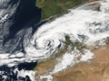
 Storm Dennis, the most intense European windstorm of the 21st century, on February 15, 2020.
 -

-
 Track of Tropical Storm Five of the 1952 Atlantic hurricane season, the northernmost forming Atlantic tropical cyclone.
 -
 A house that was wiped off its foundation after the extremely violent 2011 Hackleburg–Phil Campbell tornado.
 -

-
 Subtropical Cyclone Katie near Easter Island on May 2, 2015.
 -
 One of the first photos of the Andromeda Galaxy, taken in 1899 by Issac Roberts.
 -
 Image of the 1997 Jarrell tornado at peak intensity over the Double Creek Estates in Jarrell, Texas.
 -
 Satellite image of the 2022 Hunga Tonga–Hunga Haʻapai eruption and the extratropical remnants of Cyclone Cody.
 -
 Radar loop of the most prolific December tornado outbreak on record on December 15, 2021.
 -
 Cryovolcanoes spewing out ice at the south pole of Enceladus.
 -
 Hurricane Dorian approaching Canada as powerful extratropical cyclone on September 7, 2019.
 -
 An unrated landspout tornado near Marble, Colorado on May 29, 2021.
 -
 A record-breaking bomb cyclone off the coast of the Pacific Northwest on October 24, 2021.
 -
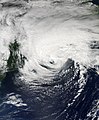
 Subtropical Storm One at peak intensity on January 16, 2023.
 -
 C/2022 E3 (ZTF), a long-period comet, on January 27, 2023.
 -
 A waterspout inside of Tropical Storm Colin on June 6, 2016.
 -
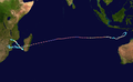 Track of Cyclone Freddy, the longest-lived tropical cyclone on record.
 -
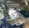
 A potential subtropical storm of the coast of Morroco on February 17, 2002.
 -
 The 1904, Moscow tornado, one of the deadliest Russian tornadoes on record.
 -
 2023 CX1 entering Earth's atmosphere over France on February 13, 2023.
 -
 Subtropical Storm Raoni off the coast of Argentina on June 28, 2021


.jpg)


-_Alessandro_Bianconi.jpg)


Tropical cyclones in 2023 (personal analysis)[edit]

Subpages[edit]
My Subpages:
Good ones/Actively working on[edit]
- My sandbox
- Effects of the 1982–83 El Niño in Peru†
- Tropical Storm Namtheun (2021)†
- Unusual areas of tropical cyclogensis†
- Potential Tropical Cyclone Four†
- F6
- 2023 Naypyidaw tornado†
- List of costliest tropical cyclones
Inactive[edit]
- Significant tornadoes of 2023
- Table of Central Pacific tropical cyclones†
- Deadliest tropical cyclones by basin
Mainspace[edit]
- List of costliest tropical cyclones
- Template:Table of F5 and EF5 tornadoes
- Weather of 1985
- October 2022 Southern Ocean cyclone
† open to editing from others
My best works[edit]
- Weather of 2023 (
 / Top ) – Started article and contributed significantly to it by adding weather events as they go
 - Template:10 deadliest tornadoes worldwide and Template:F5 and EF5 tornadoes (
 ) – Started them and my contributions are most of the template content
 - List of costliest tropical cyclones (
 / Low ) – Started article and most of the article is my contribution, had to delete "some" but I still have the original still exists here
 - Hurricane Hilary (2023) (
 / Mid ) – Started article
 - Weather of 1985 (
 / Low ) – Started article and added all events
 - October 2022 Southern Ocean cyclone (/ Mid ) – Created article
Random Tropical Cyclone ()[edit]

Hurricane Teddy was a large and powerful Cape Verde hurricane that was the fifth-largest Atlantic hurricane by diameter of gale-force winds recorded. Teddy produced large swells along the coast of the Eastern United States and Atlantic Canada in September 2020. The twentieth tropical depression, nineteenth named storm, eighth hurricane, and second major hurricane of the record-breaking 2020 Atlantic hurricane season, Teddy initially formed from a tropical depression that developed from a tropical wave on September 12. Initially, the depression's large size and moderate wind shear kept it from organizing, but it eventually intensified into Tropical Storm Teddy on September 14. After steadily intensifying for about a day, the storm rapidly became a Category 2 hurricane on September 16 before westerly wind shear caused a temporary pause in the intensification trend. It then rapidly intensified again on September 17 and became a Category 4 hurricane. Internal fluctuations and eyewall replacement cycles then caused the storm to fluctuate in intensity before it weakened some as it approached Bermuda. After passing east of the island as a Category 1 hurricane on September 21, Teddy restrengthened back to Category 2 strength due to baroclinic forcing. It weakened again to Category 1 strength the next day before becoming post-tropical as it approached Atlantic Canada early on September 23. It then weakened to a gale-force low and made landfall in Nova Scotia with sustained winds of 65 mph (105 km/h). The system weakened further as it moved northward across eastern Nova Scotia and then the Gulf of St. Lawrence, before being absorbed by a larger non-tropical low early on September 24, near eastern Labrador.
Tropical storm watches and warnings were issued for both Bermuda and Atlantic Canada in preparation for Teddy. Its large size and strength caused high waves and rip currents to impact areas hundreds of miles from its path, ranging from the Lesser and Greater Antilles to the East Coast of the United States and Atlantic Canada. Two people in Puerto Rico drowned from the strong waves while another drowned in New Jersey. Total damage is estimated to be at least $35 million. (Full article...)