
User:Pingku/SandBox
| This is not a Wikipedia article: This is a workpage, a collection of material and work in progress that may or may not be incorporated into an article. It should not necessarily be considered factual or authoritative. |

North Terrace is one of the four terraces that bound the central business district of the city of Adelaide, the capital city of South Australia. It runs east-west, along the northern edge of the CBD.[1][2]
Hmmm, well it seem that I still need to write something to push down the text a bit so that it takes up enough room that the table I constructed will start below the first photograph, which I thought it would be nice to keep in its original position. All things considered, I would rather not have gone to all this trouble, but what the heck.
Establishments on North Terrace[edit]
| East | ||
| Botanic Gardens | Botanic Road |
Rundle Park |
| Botanic Gardens (main entrance) | East Terrace | |
| Royal Adelaide Hospital | North Terrace |
The historic Botanic Hotel (partiallly converted to apartments) The historic Ayers House |
| Frome Road | Frome Street | |
| University of South Australia City East campus University of Adelaide Main campus |
First Church of Christ, Scientist Assorted businesses | |
| Bonython Hall (University of Adelaide)[3] | Pulteney Street | |
| University of Adelaide Main campus The Art Gallery of South Australia |
The historic Scots Church (Originally Presbyterian, now Uniting Church) Assorted businesses and medical practices | |
| Kintore Avenue | Gawler Place | |
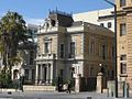
| National War Memorial Government House, the official residence of the Governor of South Australia |
The Myer Centre, part of the Rundle Mall shopping precinct The exclusive and historic Adelaide Club | |
| King William Road | King William Street | |
| Bridge support, backed by railway yards | Morphett Street Bridge (overpass) |
Morphett Street |
| North Terrace |
||
| Parkland backed by railway yards | West Terrace | |
| Parkland backed by railway yards | Port Road |
Parkland |
| West |
Tag to move photographs[edit]


North Side of North Terrace[edit]
Theoretically, the northern side of North Terrace is part of the Adelaide Parklands. However, much of the space between North Terrace and the River Torrens is occupied by cultural institutions and other public buildings. Starting from West Terrace and travelling east, these buildings include:
(West Terrace)
- Parkland
- Railway yards
- City Sk8 Park, a skateboarding facility next to the railway yards
(Morphett Street bridge)
- Adelaide Convention Centre, Exhibition Halls and Riverside Centre (partly above the railway station platforms)
- The Hyatt Regency Hotel (above the railway station platforms)
- Adelaide Railway Station building
- Adelaide Casino (inside the historic station building)
- Old Parliament House - the original South Australian Parliament building
- Parliament House
- The Adelaide Festival Centre and Elder Park are behind Parliament House, between North Terrace and the River Torrens
- Government House, the official residence of the Governor of South Australia
- The historic Torrens Parade Ground is behind Government House, between North Terrace and the River Torrens
- The South African War Memorial stands in front of Govenment House on a traffic island at the corner of North Terrace and King William Road.
- National War Memorial
(Kintore Avenue)
- State Library of South Australia
- South Australian Museum
- Art Gallery of South Australia
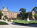
- University of Adelaide (original campus, now called the Main campus):
- Mitchell Building
- Elder Conservatorium of Music
- Bonython Hall[3]
- Napier Building
- Law Building
- University of South Australia (original campus, now called the City East campus)
(Frome Road)
(East Terrace)
South Side of North Terrace[edit]
Starting at West Terrace and travelling east, the southern side of the street includes:
(West Terrace)
- The Newmarket Hotel
- Assorted accomodation, businesses and medical practices
- The large new City West campus of the University of South Australia
- The Lion Arts Centre (in the old Fowler's Lion Flour Factory building)
(Morphett Street bridge)
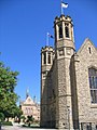
- The historic Holy Trinity Church (Anglican)
- Assorted accomodation, businesses and government offices
- The Dame Roma Mitchell building
- Assorted accomodation and various Adelaide head offices (e.g. Qantas, Origin Energy)
- Westpac Bank Adelaide head office
- The exclusive and historic Adelaide Club
- The Myer Centre, part of the Rundle Mall shopping precinct
(Gawler Place)
- Assorted businesses and medical practices
- David Jones, part of the Rundle Mall shopping precinct
- Assorted businesses and medical practices
- The historic Scots Church (Originally Presbyterian, now Uniting Church)
- Various buildings occupied by the University of Adelaide
- The historic and architecturally elaborate Freemasons building
- Assorted businesses
- The First Church of Christ, Scientist ("Christian Scientist" Church)
(Frome Street)
- Assorted businesses
- The historic Ayers House
- Assorted businesses
- The historic Botanic Hotel
(East Terrace)
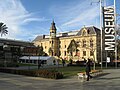
In October 2007, the extension of the Glenelg Tramline from Victoria Square to the University of South Australia City West campus was completed. The tram now operates along the entire length of King William Street, and along North Terrace between King William Street and the Morphett Street bridge. One stop is located adjacent to the Adelaide Railway Station, with the terminus at the University of South Australia City West campus.
Picture Gallery[edit]
-

-
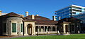
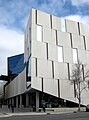 The Hawke Building, part of the UniSA, City West Campus
 -
 The Yungondi Building, part of the UniSA, City West Campus
 -
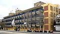
 City West terminus of Glenelg Tram - left-to-right: Hyatt Regency Hotel, Riverside Building, Morphett Street bridge, multi-storey accommodation, the old Lion Flour factory
 -

-
Adelaide Railway Station platforms 1986, during construction of the Riverside Building and prior to construction of the Adelaide Convention Centre above the platforms
-
 Part of the Adelaide Railway Station building - main entrance
 -
 Parliament House with Hyatt Regency Hotel
 -
 Opening of Parliament House, Adelaide, by the Governor-General, June 5th 1939.
 -
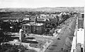
 View of the South African War Memorial, looking West along North Terrace, circa 1925.
 -
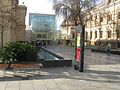
 View of the South African War Memorial, looking West along North Terrace, circa 2008.
 -

-

-
 View of North Terrace, looking east from near King William Street, circa 1940
 -
 Old State Library Building which now houses the Sir Donald Bradman collection
 -
 State Library Complex
 -
 Mortlock Library
 -
 South Australian Museum Complex
 -
 Art Gallery of South Australia and part of the South Australian Museum
 -
 Mitchell Building, University of Adelaide
 -
 Eastern side of Mitchell Building, University of Adelaide
 -
-

-

-
 Bonython Hall, University of Adelaide (looking west)
 -
 Freemasons' Hall
 -
 Waterhouse House
 -
 Waterhouse House history
 -
 Looking west from Frome Road
 -
Brookman Building, part of the UniSA City East Campus
-
-
 Terrace Houses, East End
 -
 Botanic Hotel, cnr East and North Terraces
 -


References[edit]
- ^ 2003 Adelaide Street Directory, 41st Edition. UBD (A Division of Universal Press Pty Ltd). 2003. ISBN 0-7319-1441-4.
- ^ Map of the Adelaide CBD, North Adelaide and the Adelaide Parklands.
- ^ a b c Bonython Hall is opposite Pulteney Street, and was built in 1936 as a result of a donation of over £50,000 from Sir John Langdon Bonython. Pulteney Street is the only one of the city's north-south thoroughfares (aside from East and West Terrace) which does not continue north through the parklands. Folklore has it that the Bonython donation was made on the condition that a hall be built opposite Pulteney Street, thus blocking any future path through the parklands and preventing the division of the campus by a major thoroughfare. Cite error: The named reference "Bonython" was defined multiple times with different content (see the help page).
This article needs additional citations for verification. (January 2008) |
This Australian road or road transport-related article is a stub. You can help Wikipedia by expanding it. |
This article about a place in Adelaide is a stub. You can help Wikipedia by expanding it. |