
User:Liveste/Sandbox/3
| This is a user sandbox page, not a Wikipedia article. This page is used for the development of future articles on Wikipedia, or for the expansion of existing articles. The information on this page may not yet meet Wikipedia's quality standards and is subject to change. |
| Ngāti Awa | |
|---|---|
| Iwi (tribe) in Māoridom | |
 Pūtauaki, ancestral mountain of Ngāti Awa | |
 | |
| Rohe (region) | Bay of Plenty Region |
| Waka (canoe) | Mātaatua |
| Population | 15,258 |
Ngāti Awa is a Māori iwi (tribe) traditionally centred in the eastern Bay of Plenty Region of New Zealand. Ngāti Awa traces its origins to the arrival of Polynesian settlers to New Zealand aboard the Mātaatua canoe, estimated to have arrived in the Bay of Plenty around 1350 AD. Oral traditions indicate that the Mātaatua voyagers landed at Whakatane and settled with earlier Polynesian arrivals living in the area. The iwi takes its name from two ancestors named Awanuiārangi who lived in Whakatane. In its traditional eastern Bay of Plenty base, Ngāti Awa lived alongside fellow Mātaatua tribes Ngāi Tūhoe and Te Whakatōhea, as well as Ngāti Tūwharetoa and the tribes of Te Arawa. Ngāti Awa also has historic ties to iwi across the North Island of New Zealand.
Europeans began settling in New Zealand from the late 18th century, and Māori across New Zealand began to adopt European customs and ways of living. European expansion into Ngāti Awa territory was initially limited, starting with traders in the 1830s. In 1840, Ngāti Awa chiefs signed the Treaty of Waitangi, and for 20 years lived in peace and prosperity. However, Ngāti Awa and other eastern Bay of Plenty tribes came into conflict with the New Zealand government and Crown-allied Māori during the New Zealand wars. Over 1000 km2 of Ngāti Awa land was confiscated by the colonial government, sending the tribe into a severe social, cultural and economic decline. European settlement grew rapidly in the eastern Bay of Plenty following the wars and confiscations. Māori across New Zealand gradually adopted Western lifestyles: many Ngāti Awa people gained seasonal employment and migrated to larger towns and cities. In the 1980s, Ngāti Awa began efforts to settle its historical grievances through the Waitangi Tribunal. Twenty years of research and negotiations culminated in a settlement being reached between Ngāti Awa and the New Zealand government in 2003.
In the 2006 Census, 15,258 people registered their affiliation with Ngāti Awa, making it the tenth-largest iwi in New Zealand. As of August 2011, at least 19,000 people have been listed as members of the tribe. Most Ngāti Awa people live in the eastern Bay of Plenty; other substantial populations exist in Auckland, Wellington and the Waikato. Ngāti Awa is subdivided into 22 hapū (subtribes): 20 hapū are located in the Bay of Plenty, with one each located in Auckland and Wellington. Many of the tribe's marae are concentrated near Whakatane and the town of Te Teko. The iwi is administered by Te Rūnanga o Ngāti Awa, which negotiates with government authorities on behalf of the tribe, as well as managing tribal assets and providing social services. Ngāti Awa also runs a wananga (tribal university), a hauora social health centre and a radio station.
The tribe's traditional rohe (tribal territory) roughly extends from Ohiwa Harbour and Whakatane westwards across the Rangitaiki Plains. Prominent geographical landmarks in the Ngāti Awa rohe feature in tribal oral traditions, and continue to hold symbolic importance: these include the mountain Pūtauaki; the Tarawera, Rangitaiki and Whakatane Rivers; and the islands of Moutohorā, Whakaari and Te Paepae o Aotea. Ngāti Awa culture was devastated following the wars and confiscations of the 1860s. The 1960s saw a resurgence in Māori culture nationally, and since settling its historical grievances Ngāti Awa has continued efforts to preserve its local cultural traditions. The Mātaatua wharenui – built to symbolically unify an aggrieved people, and for more than a century exhibited around the world – will take centre place from September 2011 in a new marae and cultural centre for Ngāti Awa.
History[edit]


Explanation of two types of "history":
- Oral traditions, via anthropological research
- Recorded history
Importance and implications for tribal identity (and membership), culture and society.
Oral traditions[edit]
Tribal beginnings[edit]
In oral traditions, Ngāti Awa trace their origins to the arrival of Māori settlers to New Zealand on the Mātaatua waka (canoe). Most traditions agree that the Mātaatua landed at Kakahoroa (present-day Whakatane) in the Bay of Plenty.[1] Exactly when the settlers arrived in New Zealand is less clear: ethnographer Stephenson Percy Smith posited that the Mātaatua arrived in New Zealand around 1350 AD, based on genealogical research, as part of a great fleet sailing from Hawaiki. This "great fleet" hypothesis was subsequently discredited, although an alternative time of arrival has yet to be firmly established.[2] Among the Mātaatua settlers were its captain Toroa, his brother Puhi and sister Muriwai, his son Ruaihona, and his daughter Wairaka.[1]
The Whakatane area had been settled many generations previously by a group of Māori settlers led by Toi-kai-rakau, himself a descendant of an earlier settler, Tiwakawaka. Toi established a pā called Kapu-te-rangi at Kohi Point overlooking Whakatane. By the time of the Mātaatua arrival, his descendants had become known as Te Tini-o-Toi.[3] The Mātaatua arrivals joined the descendants of Toi in settling the Whakatane area.
The present name of "Whakatane" derives from an incident during the arrival of the Mātaatua. While the men of the canoe were ashore, the Mātaatua broke away and began to drift out to sea. Wairaka, the daughter of Toroa (the canoe's captain), proclaimed "kia whakatāne au i ahau" ("I must act like a man") and, doing what only men were allowed to do, swam out to the canoe and paddled it back to shore.
Most eastern Bay of Plenty tribes can trace their ancestry to the Mātaatua settlers. Toroa's son, Ruaihona, fathered Tahinga-a-te-Rā, who in turn fathered Awanuiārangi. The name Awanuiārangi was also given to one of the son's of Toi. It is from these two ancestors – Awanuiarangi I (son of Toi) and Awanuiārangi II (descended from Toroa) – that all Ngāti Awa ostensibly claim descent and from whom the iwi derive its name.

Migrations[edit]
After the initial Mātaatua settlement in Whakatane, at some point a dispute arose between Toroa and Puhi. Traditions from several areas in New Zealand tell that Puhi took the Mātaatua and along with a number of the other settlers travelled west and north along the coast of the North Island. These settlers formed a group that controlled a significant portion of the present-day Northland region. Over many generations this branch of Ngāti Awa formed close relationships with other Northland iwi.[4] But as warfare became more commonplace in densely populated areas, conflicts with other Northland iwi including Ngāti Whātua and Ngāpuhi compelled the Northland Ngāti Awa to migrate south. Their migrations southwards proceeded in several stages, estimated to have occurred in the 16th and 17th centuries.
Two groups of Ngāti Awa migrated from the north. One group was led by the chief Titahi, who initially settled in the Tāmaki region (present-day Auckland), building pā in the area surrounding Kaipara Harbour, including one of the most famous pā in New Zealand history at Maungakiekie (One Tree Hill). Titahi's group continued to migrate southwards along the west coast of the North Island, finally settling in the Taranaki region.[5] Their descendants gave rise to the modern iwi of Te Āti Awa, who were often referred to as "Ngāti Awa" even well into the 20th century.
Another group to leave the north was led by Kauri, who left Kaitaia and travelled down the east coast of the North Island. His group settled in Tauranga, and became the ancestors of several of the Tauranga Moana iwi.[6] A group of the Tauranga settlers continued east towards the Bay of Plenty branch of Ngāti Awa, the descendants of Toroa.
Early history[edit]
No written record exists for Māori history prior to the arrival of Europeans in New Zealand. Most historical accounts of the pre-contact period rely on oral traditions. Archaeological information on Māori settlement in the Bay of Plenty region is also scarce, and little evidence,[7] if any, of human settlement prior to the Kaharoa eruption of Mount Tarawera ~1300 AD has been found.[citation needed] Nevertheless, the Bay of Plenty is believed to have been one of the earliest settled areas in New Zealand. Settlements were located in sheltered landing places, such as harbours or estuaries, including the Whakatane River. They were often built in proximity to fresh water and food sources from the ocean and the land. As the local Māori population expanded over time, horticultural land use became more prominent, and the competition for resources among local tribes saw the emergence of fortified pā.[8]
Before the 20th century, the present area of the Rangitaiki Plains was an extensive swampland. Some insights into pre-contact Māori life in the Ngāti Awa rohe have been gained through archaeological research into local sites. One of the most famous of these is Kohika Pā, a fortified village that was in use during the 17th century. The site is located along the Tarawera River south of Matata, and was built on an island in the former swampland.[9]
- Ngāti Awa was frequently at war with neighbouring iwi, including those with similar ancestry.
European contact and changes[edit]

- Musket Wars and invasion by Ngāpuhi
- Few interactions with Europeans prior to 1840: mostly missionaries (Samuel Marsden)
- Relations were generally amicable, and hapū established businesses for domestic (Auckland) and overseas (Sydney) markets
- Treaty of Waitangi signed in Whakatane on 16 June 1840 by several Ngāti Awa chiefs[10]
- Twenty years of peace and expansion of commerce
- Volkner Incident and the murder of James Fulloon
- The New Zealand Wars of the 1860s resulted in the colonial government confiscating more than 1,000 km² of Ngāti Awa land; tribe labelled "hara" (rebels)
- Hauhau wars: other tribes attacked Ngāti Awa, incl. Tūhoe and Te Whakatōhea[11]
- Confiscation and forced resettlement of hapū west of Whakatane River and Rangitaiki swamplands; confiscated land also given to rival tribes, including Te Arawa
- Struggles to survive; social disarray; land division and the Native Land Court
- Unification projects: Hotunui and Mātaatua[12]
- Religious groups, Ringatū
- Expansion of European settlement and industry (e.g., sulfur mining on Whakaari)

Twentieth century[edit]
- Prolonged cultural decline and gradual assimilation
- NB: include comparisons with Tūhoe
- NB: add quotes from other tribal leaders
- Early 20th century drainage of the Rangitaiki swamps for farmland
- Continuing efforts for compensation and tribal governance
- Local industry: dairy and timber
- Pūtauaki sold to Tasman Mill
- The Waitangi Tribunal: research efforts commence in 1980s that last almost 20 years (spearheaded by Sidney Moko Mead), producing a report outlining Ngāti Awa's historical grievances with the Crown
- Interim developments: establishment of a wananga and a radio station
Settlement and future[edit]
- In 1999, the Waitangi Tribunal determined that the confiscation of Ngāti Awa land in the New Zealand Wars by the colonial government was illegal
- Negotiations commence; final settlement reached in 2003:
- The New Zealand Government ('the Crown') acknowledged and apologised for the illegal confiscation of Ngāti Awa land during the New Zealand Wars
- The Crown paid NZ$42.39 million in reparations to Ngāti Awa
- The Crown agreed to return control of seven sites of historical and cultural significance to the iwi
- Three locations were renamed in accordance with original Ngāti Awa place names.
- New rūnanga established, which outlines future directions for the tribe
- Outline of assets
- Mātaatua wharenui: return of the wandering house[13][14]
Hapū and marae[edit]
- Concentration near Whakatane and Te Teko
- Many hapū in 1840, fewer presently
- Hapū regularly formed and disbanded, but after 1840 were generally "frozen" in place, and decreased in number after the New Zealand wars
- Presently 22 hapū; two urban hapū also exist in Auckland (Ngāti Awa-ki-Tamaki) and Wellington (Ngāti Awa-ki-Poneke)
- Mātaatua wharenui on new marae (Te Mānuka Tūtahi)
- Other uses for marae: Wairaka Marae and sittings of the youth court[15]
| Hapū | Marae | Location |
|---|---|---|
| Ngā Maihi | Tūteao | Te Teko |
| Ngāi Taiwhakaea II | Taiwhakaea | Paroa |
| Ngāi Tamaoki | Ruaihona | Te Teko |
| Ngāi Tamawera | Uiraroa | Te Teko |
| Ngāi Te Rangihouhiri II | Te Rangihouhiri II | Whakatane |
| Ngāti Awa ki Pōneke | Te Tumu Herenga Waka | Wellington |
| Ngāti Awa ki Tāmaki Makaurau | Mātaatua | Auckland |
| Ngāti Hāmua | Te Māpou | Te Teko |
| Ngāti Hikakino | Puawairua | Paroa |
| Ngāti Hokopu – Te Hokowhitu a Tū Ki Te Rāhui | Te Hokowhitu a Tū ki te Rāhui | Whakatane |
| Ngāti Hokopu – Te Whare o Toroa | Te Whare o Toroa (Wairaka) | Whakatane |
| Ngāti Maumoana / Ngāti Makerewai / Ngāti Takahanga | Te Hinga o te Ra (Te Karioi) Te Rua Kopiha |
Motiti Island Motiti Island |
| Ngāti Pūkeko | Pūkeko | Poroporo |
| Ngāti Rangataua | Rangataua | Pahou |
| Ngāti Tamapare | Rewatu | Paroa |
| Ngāti Wharepaia | Te Hokowhitu a Tū ki te Rāhui |
Whakatane Whakatane |
| Te Kahupake | (under construction) | Te Teko |
| Te Pahipoto | Kokohinau | Te Teko |
| Te Patuwai | Toroa | Whakatane |
| Te Tāwera | Iramoko | Matata |
| Te Warahoe | Tokitarete | Whakatane |
| Te Whānau o Tariao Tapuke / Ngāti Rarawhati (formerly of Ngāti Pūkeko) |
Rangimarie | Poroporo |
| Tuariki | Tuariki | Te Teko |
| Source: Te Kāhui Māngai | ||
Geography and rohe[edit]

Ngāti Awa is one of several coastal iwi tradtionally based along the eastern coastline of the Bay of Plenty in New Zealand's North Island. Over its history, the tribe's traditional rohe (tribal territory) has spanned an area from Ohiwa Harbour in the east, westwards to Whakatane and along the coastline to the town of Matata, and extending inland across the whole of the Rangitaiki Plains. This incorporates the present-day towns of Whakatane, Kawerau, Matata, Edgecumbe and Te Teko.
The abundant marine resources and temperate, maritime climate in the area helped to sustain continuous Māori settlement and activity over several centuries. Historical settlements were located along the coastline and major rivers of the region, with access to seafood and fresh water; rivers were also an important means of transport across the rohe. A significant part of the present Rangitaiki Plains was formerly a vast swampland, in which eels and flax were abundant. The swamps were drained in the early 20th century as a government initiative to produce fertile farmland. Large forests of Radiata pine, native to California, were also planted in the mid-20th century to start commercial forestry operations, including at Kawerau and Whakatane.
Geographical landmarks throughout the Ngāti Awa rohe have played a central role in the tribe's history, culture and society. Historical settlements and present-day towns have been located along major rivers in the area, including the Tarawera,[16] Rangitaiki and Whakatane Rivers. Offshore islands, including Moutohora, Motiti and Whakaari/White Island, were periodically settled and often visited for seafood or mutton birds. The central and eastern Bay of Plenty also lies within the Taupo Volcanic Zone, which spans an area from the central North Island northwards out into the bay. Major volcanic peaks include the mountain Putauaki and Whakaari/White Island, both of which have cultural significance to Ngāti Awa. More recently, geothermal activity in the area has been utilised in power generation and for recreational use in geothermal hot springs.
As part of the iwi's settlement with the New Zealand government, Ngāti Awa and the Department of Conservation have undertaken joint management of several conservation projects in the area. Three of these include the Moutohorā Wildlife Management Reserve, and the Ōhope and Tauwhare Pā Scenic Reserves – collectively known as "Te Tapatoru ā Toi".[17] Both Ngāti Awa and the DOC are involved in wildlife conservation and the restoration of native flora on Moutohora Island, maintaining scenic walkways and bird habitats near Ohope, and the preservation of historic pā sites in the vicinity of Ohiwa Harbour. Ngāti Awa is also routinely consulted in major local land management and development projects.
-
 Pūtauaki and the Tarawera River
 -
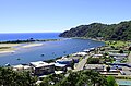 Whakatane township and the Whakatane River
 -
 Ohope Beach near Whakatane
 -
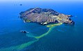
 Statue of Wairaka (left), with Moutohorā Island
 -


Population[edit]
- 15,258 people registered affiliation in the 2006 census[18]
- Ngāti Awa register lists around 19,000 members, as of June 2010[19]
- Language proficiency: 32% of Ngāti Awa able to speak the Māori language, according to 2006 Census.[20] Compares with 25% of Māori nationally.
- Education and employment[21]
- Religion (e.g., Ringatū)
- Diaspora: Auckland, Wellington, Hamilton, Australia
Culture[edit]

- 1st paragraph – Early culture
- Homogeneity among Māori in New Zealand
- Oral traditions: Mātaatua, geographical landmarks, other areas of New Zealand (e.g., Wairaka)
- Manawhenua in the Whakatane/Rangitaiki area
- Eastern Bay of Plenty reo
- Ngāti Awa influences on whakairo nationwide[22]
- 2nd paragraph – Changes since European contact
- Adoption of Western culture; loss of many traditional customs
- Historical efforts to document traditional culture (e.g., Elsdon Best, John White, Hamiora Pio)[23]
- Severe cultural decline following the New Zealand wars
- Grief, shame, hapū disbandments
- Local trends: Ringatū; Hotunui and Mātaatua wharenui
- Broader national trends: Māori culture largely replaced by Pākehā culture; loss of language; 1960s revitalisation; influence of gangster culture and reggae music among youth

- 3rd paragraph – local revitalisation
- Continuous use of rural marae, with links maintained to churches (e.g., Ringatū)
- Radio station: Te Reo Irirangi o Te Mānuka Tūtahi
- Kohanga reo and kura kaupapa
- Wananga, teaching Ngāti Awa culture
- Notable people: musicians, artists, sportspeople, tōhunga, kaumātua
- Local events: Ngāti Awa festival; Mātaatua Iwi Challenge[24]; regional kapa haka competitions
- 4th paragraph – present initiatives and challenges
- Building more marae
- Retention of marae culture and knowledge under threat[25]
- Quote from Hirini Mead on loss of haka and kapa haka groups
- Disconnected youth and encroachment of gang culture
- Rūnanga publications on oral traditions and Te Reo o Ngāti Awa
- End section with upcoming reopening of Mātaatua wharenui on new marae, to serve as a cultural centre for Ngāti Awa (PICTURES WOULD BE NICE)
Iwi organisations[edit]
- From 2005, Te Rūnanga o Ngāti Awa became the new governing body of the iwi. Representatives from the rūnanga were responsible for negotiating the settlement with the government on behalf of Ngāti Awa. Based in Whakatane, the rūnanga manages the financial assets of the iwi, and promotes cultural, educational and economic development in the region.
- Conferences: Mataatua Declaration; CEESP (IUCN) Sharing Power
- Te Whare Wānanga o Awanuiārangi
- Te Reo Irirangi o Te Mānuka Tūtahi (Sun FM)
- Ngāti Awa Research and Archives Trust and Ngāti Awa Whakapapa Committee
- Establishment of Research Centre in 1989[26]
- Environment Ngāti Awa
Commerce and social services[edit]

- Historical commerce: subsistence, trading, hapū and local resources
- European contact: establishment of businesses for export markets; acquisition of muskets; trading vessels
- New Zealand wars leads to subsistence and seasonal labour in European industries and infrastructure projects (e.g., Rangitaiki drainage)
- Later industries: dairy farming in the Rangitaiki and forestry around Kawerau and Whakatane
- Participation in rural town economies: Whakatane thrives, Kawerau becomes stagnant
- Treaty assets and commercial development: Ngāti Awa Group Holdings Ltd
- Te Tohu o te Ora o Ngāti Awa (Ngāti Awa Social and Health Services): social health, hauora
- Institute for Post Treaty Settlement Futures, providing strategies to help iwi with settlement negotiations with the Crown as well as managing settlement assets.[27]
- Asset base funding social development programs (e.g., scholarships)
- Movement into acquiring state housing in Whakatane.[28]
- Foreshore interests
See also[edit]
References[edit]
- ^ a b Harvey, Layne (26 September 2006). "Ngāti Awa". Te Ara: The Encyclopedia of New Zealand. Retrieved 28 March 2007.
- ^ Taonui, Rāwiri (16 March 2009). "Canoe traditions". Te Ara: The Encyclopedia of New Zealand. Retrieved 8 January 2011.
- ^ "Introduction to the Tribes". The Ngāti Awa Raupatu Report. 1999. Retrieved 8 January 2011.
- ^ Yarborough 1906, pp. 224–6
- ^ Stone 2001, pp. 15–8
- ^ Mead 1997, p. 253
- ^ "Precious tiki returned to iwi". 3 News. 20 August 2010. Retrieved 19 September 2011.
- ^ Law 2008, p. 10
- ^ Law 2008, pp. 71–2
- ^ "The Bay of Plenty Treaty Copy - Signatories to the Treaty of Waitangi". New Zealand History Online. updated 24 November 2006. Retrieved 29 August 2011.
{{cite web}}: Check date values in:|date=(help) - ^ Cowan 1958, pp. 314–25
- ^ Gosden 1999, pp. 187–8
- ^ Tahana, Yvonne (17 September 2011). "Ngati Awa whare comes home". The New Zealand Herald. Retrieved 19 September 2011.
- ^ Bourn, Alex (17 September 2011). "Wharenui returns home after a century abroad". 3 News. Retrieved 19 September 2011.
- ^ Motion, Samantha (8 June 2011). "Wairaka Marae to host seventh youth court". Whakatane Beacon. Retrieved 19 September 2011.
- ^ Dodd 2010, pp. 53–63
- ^ Department of Conservation. "Te Tapatoru ā Toi - Joint Management Committee". Retrieved 6 November 2011.
- ^ "2006 Census – QuickStats About Māori (revised)". Statistics New Zealand. 4 April 2007. Archived from the original on 28 September 2007. Retrieved 25 May 2007.
- ^ Te Rūnanga o Ngāti Awa 2010, p. 35
- ^ Te Rūnanga o Ngāti Awa 2011, p. 9
- ^ Leighton et al. 2006, pp. 8–12
- ^ Ngata 1958, pp. 31–5
- ^ Mead, Hirini (updated 1 September 2010). "Pio, Hamiora Tumutara Te Tihi-o-te-whenua". Dictionary of New Zealand Biography. Retrieved 14 August 2011.
{{cite web}}: Check date values in:|date=(help) - ^ Ogle, Adyn (13 September 2011). "Challenge to get iwi event right". Whakatane Beacon. Retrieved 16 September 2011.
- ^ "Ngati Awa hapu could lose touch with culture". Whakatane Beacon. 16 December 2009. Retrieved 6 January 2011.
- ^ Smith 2006, p. 128
- ^ "Mead to head institute". Whakatane Beacon. 1 December 2010. Retrieved 22 January 2011.
- ^ Collins, Simon (29 March 2011). "Bay iwi eyes state houses but wants bargain buy". The New Zealand Herald. Retrieved 14 August 2011.
Bibliography[edit]
- Cowan, James (1956). "Te Kooti's raid on Whakatane". The New Zealand Wars: A History of the Maori Campaigns and the Pioneering Period: Volume II: The Hauhau Wars, 1864–72. Wellington: R. E. Owen. pp. 314–26.
- Dodd, Materoa (2010). "Effects of Industry on Maori Cultural Values: The Case of the Tarawera River". Indigenous Voices, Indigenous Research (WINHEC): 53–63.
- Gosden, Chris (1999). Anthropology and Archaeology: A Changing Relationship. London: Routledge. ISBN 0-415-16250-5.
- Law, Garry (2008). Archaeology in the Bay of Plenty (PDF). Department of Conservation.
- Leighton, Enid; van Seventer, Dirk; Haig, Robert; Hall, Simon (2006). "Understanding regional labour markets - Ngati Awa case study (executive summary, draft report)" (PDF). Ngāti Awa, Department of Labour.
- Mead, Sidney M. (1997). "The significance of being Ngāti Awa". Landmarks, bridges and visions: aspects of Maori culture: essays. Victoria University Press. pp. 250–63. ISBN 0-86473-317-8.
- Ngata, Apirana (1958). "The origin of Maori carving (Part 1)". Te Ao Hou (22): 30–7.
{{cite journal}}: Unknown parameter|month=ignored (help) (Continued in Part 2. Te Ao Hou (23): 30–4.) - Smith, Linda Tuhiwai (2006). Decolonizing methodologies: research and indigenous peoples. Zed Books.
- Stone, R. C. J. (2001). From Tāmaki-makau-rau to Auckland. Auckland University Press. ISBN 1-86940-259-6.
- Te Rūnanga o Ngāti Awa (2010). "Annual Report 2009-2010" (PDF).
- Te Rūnanga o Ngāti Awa (2011). "Te Rautaki Reo ō Ngāti Awa: The Ngāti Awa language strategy 2010 - 2015" (PDF).
- Yarborough, A. G. (1906). "Ngati-Awa in the north". Journal of the Polynesian Society. 15 (4): 224–6.
External links[edit]
[[Category:Iwi and hapu|Ngati Awa]] [[mi:Ngāti Awa]]