User:IrfanFaiz/Sandbox/Typhoon Chaba (2004)
| super typhoon | |
|---|---|
| Formed | August 17, 2004 |
| Dissipated | August 31, 2004 |
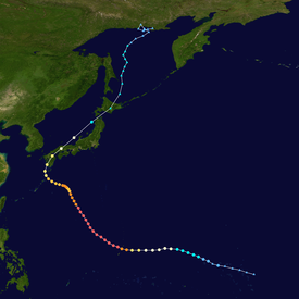
Typhoon Chaba (international designation: 0416, JTWC designation: 19W, and sometimes called Super Typhoon Chaba) was a powerful Category 5 typhoon that struck Southern Japan as a minimal typhoon. Chaba caused 7 deaths almost all due to floods and landslides. Chaba was one of the most intense typhoons in the 2004 Pacific typhoon season, tying with Typhoon Dianmu of the same season.
Storm history[edit]

Tropical storm (39–73 mph, 63–118 km/h)
Category 1 (74–95 mph, 119–153 km/h)
Category 2 (96–110 mph, 154–177 km/h)
Category 3 (111–129 mph, 178–208 km/h)
Category 4 (130–156 mph, 209–251 km/h)
Category 5 (≥157 mph, ≥252 km/h)
Unknown
A tropical depression formed east of Kwajalein on August 17 and was tracked westward. Tropical Depression 19W began to intensify rapidly. It continued to track westward along the southern periphery of a ridge, it reached Tropical Storm status on August 19 and was named "Chaba" a type of a tropical flower. On August 21, Chaba formed a dual-outflow channel and it allowed the cyclone to intensify rapidly and reach a maximum intensity of 110 kt (130 mph, 210 km/h) and a minimum pressure of 910 mbar (hPa) while being approximately 75 nautical miles northwest of Guam.
A trough caused Chaba to track to the northwest and warm waters in the regions along with a well-defined outflow structure allowed Chaba to maintain it's peak intensity for a continuous period on August 26. The trough then moved eastward and caused the ridge to strengthen and shift the track of Typhoon Chaba slowly westward for a couple of days. Another trough subsequently moved off the east coast of China causing the track to shift northward towards Kyushu on August 29. Typhoon Chaba made landfall near city of Kushikino as a weakened typhoon on the southwest coast of Kyushu at approximately midnight UTC August 30 when a weather station on the coast measured winds at 108 knots. Chaba began to accelerate northeastward across Kyushu and onto Honshu near Hikari.
Chaba crossed southwestern Honshu and entered the Sea of Japan where it began to transition into an extra-tropical system. Chaba weakened to a tropical storm, skimmed the northern edge of Honshu before crossing into Hokkaido near Shizunai and the system became extra-tropical on August 31.[1]
Impact[edit]
When Chaba came ashore, most of the damage was caused by severe floods. An 82-year old woman was found dead in a flooded home at Kurashiki. A man whose body was unable to identify was found in a car near Takamatsu. And another person was in a coma after falling off a balcony of a home at Imajo.[2]
A body of a Vietnamese sailor was found around 700 kilometres (434 miles) southwest of Tokyo. Three more crew members are missing when a freighter ran aground by the storm. A 75-year-old Japanese man was still missing from Tokushima on the southern main island of Shikoku. Many people lost their homes due to landslides and flooding caused by the typhoon. Agricultural damage was estimated up to 8 billion Yen ($73 Million (2004 USD).
Other than the destruction caused by the typhoon, some positive effects are the rainfall dropped by the typhoon to be helpful to farmers due to hot weather in Japan.[3]
See also[edit]
List of notable tropical cyclones
