User:IrfanFaiz/Sandbox/Hurricane Daniel
| hurricane | |
|---|---|
| Formed | July 17, 2006 |
| Dissipated | July 26, 2006 |
Hurricane Daniel was a powerful Category 4 Pacific hurricane that developed an annular hurricane structure during it's peak. Hurricane Daniel breifly threatened the Hawaiian Islands but it weaken rapidly, miles southeast of the islands.
Storm History[edit]

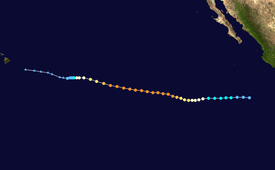
Tropical storm (39–73 mph, 63–118 km/h)
Category 1 (74–95 mph, 119–153 km/h)
Category 2 (96–110 mph, 154–177 km/h)
Category 3 (111–129 mph, 178–208 km/h)
Category 4 (130–156 mph, 209–251 km/h)
Category 5 (≥157 mph, ≥252 km/h)
Unknown
On July 16, a tropical disturbance formed off the western Central Amrican coast and quickly increased in convective activity and organization. The NHC designated it as a tropical depression that night (July 17 UTC). The depression continued to organize and was designated as a tropical storm the next day. On the same day, Daniel continued to strengthen, it began to show signs of a hurricane with a spiral structure that wraps all the way from the center of the circulation. Satellite images began to show signs of a developing eye. The storm moved over an area of really low wind shear and warm sea-surface temperatures. NHC began to forcecast this hurricane to reach major hurricane status. Hours later, the storm rapidly intensify to a hurricane, during it's intensification, a banding-eye feature began to form at the center.
External links[edit]
- See the NHC's archive on Hurricane Daniel.
- The CPHC will begin issuing advisories on Hurricane Daniel effective 1500 UTC July 24.
