User:HistoryofIran/Greater Khorasan
| This is a Wikipedia user page. This is not an encyclopedia article or the talk page for an encyclopedia article. If you find this page on any site other than Wikipedia, you are viewing a mirror site. Be aware that the page may be outdated and that the user in whose space this page is located may have no personal affiliation with any site other than Wikipedia. The original page is located at https://en.wikipedia.org/wiki/User:HistoryofIran/Greater_Khorasan. |


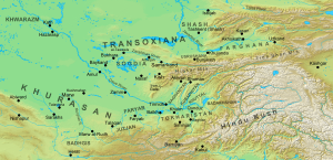
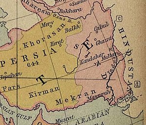
Khorasan (also spelled Khurasan: Middle Persian: Xwarāsān; New Persian: خراسان, pronounced [xoɾɒːˈsɒːn] ⓘ), was a historical region that formed the eastern part of Greater Iran. The region, now split between the present-day countries of Iran, Afghanistan and Turkmenistan, stretched from the Caspian region to the Oxus River.[1] The region was often subdivided into four quarters: Nishapur (present-day Iran), Marv (present-day Turkmenistan), Herat and Balkh (present-day Afghanistan) were the centers, respectively, of the westernmost, northernmost, southernmost, and easternmost quarters.[2][3] The term Greater Khorasan is today sometimes used to distinguish the larger historical region from the modern Khorasan Province of Iran (1906–2004), which roughly encompassed the western half of the historical Greater Khorasan.[4]
Khorasan was first established as an administrative division in the 6th-century (approximately after 520) by the Sasanians, during the reign of Kavad I (r. 488–496, 498/9–531) or Khosrow I (r. 531–579).[5] It comprised the eastern and north-eastern part of the empire, and was administered by a spahbed (marshal). Khorasan continued as an administrative division in the early Islamic era, where it became a common way of referring to not only the eastern and north-eastern Sasanian realm, but also beyond the Oxus, namely Sogdia and Osrushana. Sistan and Kabul were also counted as a part of the region, though less frequently.[6]
Indeed, Islamic geographers often regarded everywhere east of so-called Jibal or what was subsequently termed Persian Iraq, as being included in a vast and loosely-defined region of Khorasan, which might even extend to the Indus Valley and Sindh.[1] The boundary between these two was the region surrounding the cities of Gurgan and Qumis. In particular, the Ghaznavids, Seljuqs and Timurids divided their empires into 'Iraqi' and 'Khorasani' regions. Khorasan is believed to have been bounded in the southwest by desert and the town of Tabas, known as "the Gate of Khorasan",[7]: 562 from which it extended eastward to the mountains of central Afghanistan.[8] Sources from the 10th-century onwards refer to areas in the south of the Hindu Kush as the Khorasan Marches, forming a frontier region between Khorasan and Hindustan.[9][10]
Etymology[edit]
The name signifies "the Land of the Sun" or "the Eastern Province".[11][12]
History[edit]
Khorasan was first established as an administrative division in the 6th-century (approximately after 520) by the Sasanians, during the reign of Kavad I (r. 488–496, 498/9–531) or Khosrow I (r. 531–579).[5] It comprised the eastern and north-eastern part of the empire, and was administered by a spahbed (marshal).[6] The
Under Kavad I (r. 488–496, 498–531) and his son and successor Khosrow I (r. 531–579) the Sasanian Empire was divided four frontier regions (kust in Middle Persian), with a military commander (spahbed) in charge of each district.[13][14] The frontier regions were known as xwarāsān (East), xwarārān (West), nēmrōz (South) and abāxtar (North, later to be changed to Adurbadagan).[15] The province of Adurbadagan, along with provinces such as Gilan and Caucasian Albania were part of the northern quarter.[14]
First established in the 6th-century as one of four administrative (military) divisions by the Sassanids,[16] the scope of the region has varied considerably during its nearly 1,500-year history. Initially, the Khorasan division of the Sassanid empire covered the north-eastern military gains of the empire, at its height including cities such as Nishapur, Herat, Merv, Faryab, Talaqan (around modern Turkmenabat), Balkh, Bukhara, Badghis, Abiward, Gharjistan, Tus, Sarakhs and Gurgan.[17]
References[edit]
- ^ a b Bosworth 1986, p. 56.
- ^ Le Strange 1905, p. 382.
- ^ Minorsky 1938, p. 645.
- ^ Dabeersiaghi, Commentary on Safarnâma-e Nâsir Khusraw, 6th Ed. Tehran, Zavvâr: 1375 (Solar Hijri Calendar) 235–236
- ^ a b Schindel 2013a, pp. 136–141.
- ^ a b Rezakhani 2017, p. 169.
- ^ Sykes, P. (1906). A Fifth Journey in Persia (Continued). The Geographical Journal, 28(6), 560-587.
- ^ Cite error: The named reference
Britannicawas invoked but never defined (see the help page). - ^ Minorsky, V. (1937). Hudud al-'Alam, The Regions of the World: A Persian Geography, 372 A.H. - 982 A.D. London: Oxford UP.
- ^ Cite error: The named reference
Baburnamawas invoked but never defined (see the help page). - ^ Sykes, M. (1914). "Khorasan: The Eastern Province of Persia". Journal of the Royal Society of Arts, 62(3196), 279-286.
- ^ A compound of khwar (meaning "sun") and āsān (from āyān, literally meaning "to come" or "coming" or "about to come"). Thus the name Khorasan (or Khorāyān خورآيان) means "sunrise", viz. "Orient, East". Humbach, Helmut, and Djelani Davari, "Nāmé Xorāsān" Archived 2011-01-02 at the Wayback Machine, Johannes Gutenberg-Universität Mainz; Persian translation by Djelani Davari, published in Iranian Languages Studies Website. MacKenzie, D. (1971). A concise Pahlavi dictionary (p. 95). London: Oxford University Press. The Persian word Khāvar-zamīn (Persian: خاور زمین), meaning "the eastern land", has also been used as an equivalent term. DehKhoda, "Lughat Nameh DehKhoda" Archived 2011-07-18 at the Wayback Machine
- ^ Axworthy 2008, p. 60.
- ^ a b Ghodrat-Dizaji 2010, p. 70.
- ^ Ghodrat-Dizaji 2010, p. 71.
- ^ Rezakhani, K. (2017). Reorienting the Sassanians: East Iran in Late Antiquity. Edinburgh: Edinburgh University Press. ISBN 978-1-4744-0029-9.
- ^ Cite error: The named reference
bosworth-eoiwas invoked but never defined (see the help page).
Sources[edit]
- Le Strange, Guy (1905). The Lands of the Eastern Caliphate: Mesopotamia, Persia, and Central Asia, from the Moslem Conquest to the Time of Timur. New York: Barnes & Noble, Inc. OCLC 1044046.
- Minorsky, V. (1938). "Geographical Factors in Persian Art". Bulletin of the School of Oriental Studies. 9 (3): 621–652. doi:10.1017/S0041977X00078411. JSTOR 608226. S2CID 191466923. (registration required)
