
Tremblois-lès-Rocroi–Petite-Chapelle railway
| Tremblois-lès-Rocroi–Petite-Chapelle | ||||||||||||||||||||||||||||||||||||||||||||||||||||||||||||||||||||||||||||||||||||||||||||||||
|---|---|---|---|---|---|---|---|---|---|---|---|---|---|---|---|---|---|---|---|---|---|---|---|---|---|---|---|---|---|---|---|---|---|---|---|---|---|---|---|---|---|---|---|---|---|---|---|---|---|---|---|---|---|---|---|---|---|---|---|---|---|---|---|---|---|---|---|---|---|---|---|---|---|---|---|---|---|---|---|---|---|---|---|---|---|---|---|---|---|---|---|---|---|---|---|---|
| Technical | ||||||||||||||||||||||||||||||||||||||||||||||||||||||||||||||||||||||||||||||||||||||||||||||||
| Line length | 17 km (11 mi) | |||||||||||||||||||||||||||||||||||||||||||||||||||||||||||||||||||||||||||||||||||||||||||||||
| Track gauge | Until 1903: 800 mm (2 ft 7+1⁄2 in) after 1903: 1,000 mm (3 ft 3+3⁄8 in) | |||||||||||||||||||||||||||||||||||||||||||||||||||||||||||||||||||||||||||||||||||||||||||||||
| ||||||||||||||||||||||||||||||||||||||||||||||||||||||||||||||||||||||||||||||||||||||||||||||||
.png)
.jpg)
The Tremblois-lès-Rocroi–Petite-Chapelle railway was a 17 kilometres (11 miles) long narrow gauge and later metre gauge railway in the north of France, the first section of which was put into service in 1895. It operated until 1950.[2]
History[edit]
The first, 12 km long section from Tremblois-lès-Rocroi to Rocroi line was built by the Chemins de fer départementaux des Ardennes in 1897 as a narrow-gauge railway with the unusual gauge of 800 mm. In 1903, following a change in the law, the line was converted to metre gauge. It was extended across the border to Petite-Chapelle in Belgium in 1905 and operated until 1950.[2]
Stations[edit]
-
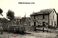 Tremblois-lès-Rocroi train station
 -
 Petit Chapelle train station
_-_La_Gare_02.jpg)
